Quantcast
Channel: Geotripper
Viewing all 1182 articles
Browse latest View live

Physics Makes for a Beautiful Moment in a Day

$
0
0


This post is off the beaten geo-track today, but there is a little bit of science involved. Our new Science Community Center at Modesto Junior College, which I have mentioned extensively in previous posts, has many remarkable features that represent educational opportunities. There are the big ones like the observatory and planetarium, and there are others built into the functionality of the building, like the stairwell. It is a rather grand circular stairwell that climbs four floors (three stories of labs and classrooms, and a fourth story of astronomical equipment storage and access to the rooftop observatory). Each step has one of the letters representing the DNA sequencing of a protein related to insulin, but the most dramatic aspect is the DNA double helix spiral sculpture that winds from the base of the stairwell to the very top. It is a dramatic way to get to class.

I have an early class and to beat traffic snarls I usually arrive well before 8 AM, and at that hour almost no one is in the building. It is a pleasant couple of moments to wander up the stairs in silence before the start of a busy day. Except for the bird...

For months, there has been a bird singing somewhere in the stairwell (it is an exterior stairway, so the bird isn't trapped or anything). The shape of the spiral channels the bird song and amplifies it, so that it is difficult to tell where it is coming from. I always assume that it is near the top, since that is the least-used part of the stairs, so I will sometimes take the camera and try to find out what species is making such a pretty song. I didn't find it up there, but I looked down from my spot on the fourth floor and realized the bird was way down on the first floor, perched on a support bracket for the DNA spiral.

There weren't any exotic species hiding out on our stairwell, it was a common House Finch (Carpodacus mexicanus). If I were any kind of real birder, I would have known the song because these birds are at the feeder in my backyard every day. But take the simple song of a finch and put it into an acoustical sound chamber, and the song becomes a symphony. It's a nice way to begin a chaotic day.


Out of the Valley of Death: Geology at Fifty-five

$
0
0

One of the first things I tell my students (and occasionally even with some success) is "don't sleep while traveling in the vans". Death Valley National Park is the largest national park in the lower 48 states, and no matter how much time one has, it's hard to take it all in. When you only have four days, it's pretty well impossible, but there is still much to see in transit between stops. On our third day out we were set to explore the northern end of Death Valley, which in a park that is mostly desert wilderness, feels even more isolated and lonely (despite the presence of Scotty's Castle up one of the side canyons).
The day started with a stunning sunrise as seen from one of the most isolated RV parks in the American west, Stovepipe Wells. The campground is literally a parking lot, but it's a parking lot with one of the most incredible views possible. The resort is situated on the distal end of the huge alluvial fan that emerges from Mosaic Canyon on Tucki Mountain, which we'll check out in a future post. The elevation is sea level, but it somehow feels higher, given the spectacular and far-ranging view.
Two great desert mountain ranges form the boundaries of the northern reaches of Death Valley, the Cottonwoods on the left and the Grapevine Mountains on the right in the picture above. The mountains tower over the valley floor, reaching nearly 9,000 feet above a valley floor that is barely above sea level. The view extends thirty miles or more.
A drive north towards the end of the valley reveals a series of classic desert features, starting with the Mesquite Flat sand dunes, sometimes known as Death Valley dunes. Sand dunes are picturesque enough by themselves, but in Death Valley they have a dramatic backdrop of high barren mountains.
We raced by at 55 miles per hour ("Honest, officer!"), but cameras these days are versatile, capturing the image as if we were standing still. And this is the sort of incredible sight one could miss if one is snoring away.
The dunes have formed here because prevailing winds sweep down the northern reaches of Death Valley (and a number of destroyed tents over the years can attest to the power of these winds). The vast bulk of Tucki Mountain at the north end of the Panamint Mountains stands in the path of these winds, causing them to break up and form eddies. The sand accumulated in the region as the powerful winds lose energy and drop their load of sand and dust. They are sometimes referred to as star dunes, or modified sub-barchan dunes. Even if you've never been to Death Valley, you've probably seen these dunes anyway; they formed the backdrop for the droids lost on the planet Tatooine in the original Star Wars movie.

In the picture above, one can see the valley floor beyond the dunes is interrupted by a terrace of some sort. This is the scarp for the Furnace Creek fault zone which is one of the important structural features of the Death Valley graben.
A closer look provides a view of light-colored sedimentary rocks exposed in the face of the scarp. The fine-grained mud and silt layers are part of the Furnace Creek formation, which was deposited into a fault trough similar to present-day Death Valley, but oriented in a more northwest-southeast direction. Crustal stretching has effected the crust in the region more than once. The erosion of the Furnace Creek formation in this dry environment produces badlands topography, which we will explore in greater detail in another post.
The fault system interrupts the surface of the alluvial fan, shifting it in an right lateral direction (the rocks across the fault are displaced to the observer's right). These faults roughly parallel the San Andreas fault, which lies far to the west. The fault is presumably still active, but has not produced a major earthquake in modern times.
Another incredible sight visible from the road is the series of alluvial fans that extend from the edge of the mountains down to the valley floor. They build up as the rare but violent flash floods and mudflows carry boulders and debris across the valley floor. They have a somewhat convex slope, becoming steeper near mountain front. Death Valley is famous for the variety and number of fans it has.
The fans reveal variations in color. The darker surfaces on the fans result from desert varnish, a mixture of manganese oxides and clay that coat the exposed surfaces of the rock. It accumulates over time, and the origin is debated. Bacteria are likely involved in the process.

As we drove further north, the valley floor narrowed, and we soon reached an area where the alluvial fans from the two mountain ranges merged in the center of the valley. We were approaching the end of the Death Valley graben. In the distance we could see dark-colored rocks coating the surface of the alluvial fans. We had reached the volcanoes of Death Valley.

In the next post: the Ubehebes!

Out of the Valley of Death: What the Heck Happened at Ubehebe?

$
0
0
The geology at Death Valley National Park is naked and raw. Nothing is hidden beneath a soft matte of vegetation. It's in your face, all the processes of tectonism, volcanism, erosion, and deposition. Every era and most of the epochs of the geologic time scale are represented somewhere in the boundaries of the park. Not even Grand Canyon National Park can make that claim. On the previous day we had explored the oldest rocks in the American West, the contorted metamorphic rocks of the Black Mountains and the ancient sediments of the Pahrump Group.

Our first destination on our third day of exploration in the park was the Ubehebe Craters at the north end of the valley, a place representing the opposite extreme in time. The events that took place here can be measured in just hundreds or thousands of years. On the drive there we were treated to amazing views of fault scarps, sand dunes, and alluvial fans, which formed mostly in the last few tens of thousands of years.

To arrive at Ubehebe Crater is kind of an otherworldly experience. For miles, the road has been following the broad rocky surfaces of the many alluvial fans that flank the Grapevine Mountains. The valley floor between the Cottonwoods and the Grapevines narrows and soon the alluvial fans merge in the center of the valley and in a few places the road climbs in earnest. But soon the Cottonwood Mountains come to an end, with the final ridge tapering down to the valley floor. We've reached some kind of a structural nexus. The formerly deep trough of the northern part of Death Valley seems to pinch out, and another valley merges with it from the south. The Ubehebe Craters have formed along the intersection of the faults that formed the valleys. The crustal weakness of the fault zones allowed the magma to rise from deep in the Earth almost to the surface.

It's clear when standing on the rim of Ubehebe Crater that something big happened here. This hole is a half mile across (~1 km) and around 700 feet (215 meters) deep. Whatever happened here did so more than once. There are perhaps a dozen overlapping craters, and each of them is rimmed with dozens of layers that represent numerous explosions. What in the heck happened?

The red, orange and yellow layers below the rim provide some clues. They are partly composed of alluvial fan gravels, but mostly they are fine-grained lake sediments. And they used to be saturated with groundwater. The darker rocks along the rim are composed of bits and pieces of basalt and volcanic ash. The volcanic rocks mantle several square miles around the craters (below).

The best way to see the details of Ubehebe Crater is to walk the rim (and to walk down to the bottom, but that will be a story for a different time).  The gullies that have been carved into the sediments are shallow, indicating the recency of the events here.

Still the trail is steep in a few spots. It's about one and a half miles of up and down pathways leading around the rim. From high points, one can see the overlapping cones and the layers of basaltic material.

From the highest part of the rim, one can see the strong contrast between the orange and yellow sediments in the wall of Ubehebe. They mark the location of a fault line related to the Cottonwood Mountains just to the south.

It's quite a view from the top!

The only actual lava at the complex can be seen inside the crater of Little Hebe, in the picture below. Little Hebe is the remains of spatter cone that was later blown apart by the kind of explosions that formed the rest of the craters in the vicinity.

So here at Ubehebe are the ingredients for an explosive event. Saturated lake sediments, a fault line providing a conduit for magma to approach the surface, and the tendency of water under pressure to explode when it gets too hot. The Ubehebe Craters are world-class examples of maars, the craters that result from groundwater (phreatic water) flashing to steam in an explosive manner.

It must have been awe-inspiring to witness the explosions, and considering that human artifacts have been discovered underneath some of the ash deposits, there is a very good chance that people saw the event take place. Precise dating of the explosions has proven challenging, but few researchers think that the eruptions were more than 6,000 years ago, and some recent findings provide hints that the eruptions could have been only a few centuries ago...and the conditions responsible for the eruption are still present. What a spectacle it would be if it happens again!

There was one thing extraordinary about our visit last February...the air was calm! The narrow constriction at the head of the northern stretch of Death Valley causes winds to be funneled across the rim of the craters, and it's usually...um..."breezy" up there. As in barely able to stand up straight. But this day was one of the most pleasant I have ever experienced.

The display at the parking lot at Ubehebe provides a nice overview of the overlapping craters. It is easy to combine a tour of Scotty's Castle (interesting but not very geological) and Ubehebe Craters. They are only a few miles apart. Ubehebe is also the starting point for the rough road leading to Racetrack Playa and the sliding stones. Another rough road heads north across Eureka Valley to Big Pine in Owens Valley. It is another road that I intend to explore one of these days!

We got in the vans and headed south with the intention of walking into an upside-down mountain. But that will in the next post!

You Don't Know What You've Got 'Til It's Gone: They Burned Paradise...

$
0
0
My God...

Nothing beautiful today; nothing inspiring...

Twenty years ago I paid my first visit to the destruction wrought by the eruption of Mount St. Helens. I stood on a high viewpoint on Windy Ridge after a long drive through downed trees and destruction and looked at a vast area and found it hard to believe that one explosion had so completely devastated a region. The ash blast from St. Helens destroyed an area of 230 square miles (600 square kilometers).

402 square miles (1,040 square kilometers). Nearly twice the area of St. Helen's destruction. That's what the Rim Fire did to my home forest, Stanislaus, and Yosemite National Park. I saw it for the first time today, and it devastated me.

I've been to Yosemite perhaps 80 times in the quarter century that I have been teaching at Modesto Junior College. I grew to love the entire region surrounding the park, and some valleys and streams became as familiar to me as my own backyard.

And now it's changed forever, if forever is the time remaining in my life. All because some clueless moron lit an illegal fire to cook his lunch in the forest, despite a crippling drought, extremely dry conditions, and a restriction on all fires. Are people really this stupid?

I know the whole argument that arose after three-quarters of Yellowstone National Park burned up decades ago. Fire is natural, fire is good, fire leads to rejuvenation of the ecosystem, all those things that are no doubt true. But that doesn't relieve the awful feeling that so much that was good was destroyed all at once, and there really wasn't a damn thing we could do about it.

Global warming and climate change will no doubt lead to many changes in the forest above my home. The new forest will be quite different from the one that passed away into nothingness last fall. Probably more drought-tolerant shrubs and fewer trees. 

The areas we traversed on our drive home still contained standing trees, as if there were some hope that life survived in the trunk somehow. But no, the needles were brown because even though the trees were not burned entirely, their cambium layer within the trunk was boiled away and the trees are dead as surely as if they had burned to the ground.

I can only offer this little bit of hope.

There were pockets of green here and there. Bits of forest had been passed over by the fast-moving flames. The horrific drought continues, but late rains in March provided enough moisture for grasses and flowers to blossom and start recolonizing the burned landscape. It's not much, but it will have to do...

The Yosemite No One Sees in Summer...the Merced River Canyon

$
0
0
The drought in California is horrific. It is quite probably the worst drought in centuries, but we received a slight respite in the form of showers and snow during the last part of March and early April. It was a drop in the bucket towards relieving the huge water deficit that has built up in the last few years, but it gave a shot of energy to the seedlings of grasses and wildflowers. They perhaps should have sprouted and grown months ago, and they will be dried out in a few short weeks, but this week, the Sierra Nevada foothills were alive with color.
We were on our way to Yosemite Valley for our geology field studies course last Saturday, and I joked (only in half-jest) that the students had to "earn" the right to learn the geology of Yosemite Valley by first exploring the canyon of the Merced River. We had to prepare ourselves by undertaking a journey through the rocks that predate the granitic rocks that form the walls of the iconic valley. Our route took us through the foothill towns of Snelling and Hornitos, and then we drove up Highway 140 through Mariposa, over Midpines Summit and down into the deep gorge of the Merced River (originally the "Rio de Nuestra Señora de la Merced (River of Our Lady of Mercy)".
Highway 140 winds back and forth through a series of metamorphic terranes, bands of deformed and twisted rocks that traveled across the Pacific Ocean to be mashed into the western edge of the North American Continent. The rocks include slate, schist, marble, phyllite, quartzite and greenstone. These were the ancient rocks (between 600 and 200 million years old) that were intruded by the granitic rocks that eventually were exposed and eroded to form the dramatic cliffs of Yosemite Valley.

The Sierra Nevada is a huge westward tilted block. The slope has allowed the rivers draining the mountain range to carve deep gorges, some deeper than the Grand Canyon (Kings Canyon to the south is about 8,000 feet deep!). The depth of the Merced is more like 2,000 to 3,000 feet deep downstream of Yosemite, and in any other setting in most any other state, this would be enough for the establishment of national parks and the like. Instead, it is "just" the preliminary canyon one must pass through before arriving at Yosemite.

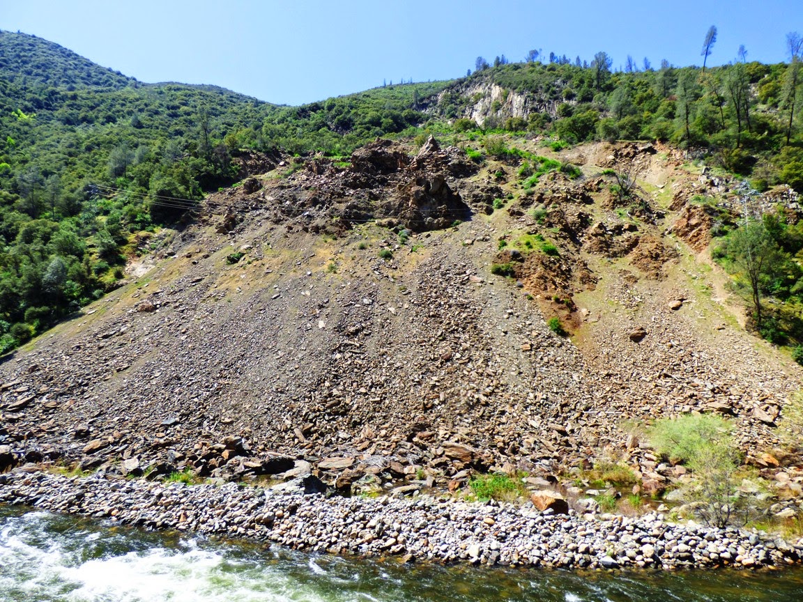
The carving of such deep canyons can have serious geologic consequences for society. The slopes of such canyons are inherently unstable, and mass wasting (landsliding) is a constant hazard. The building of roads and railways adds to the instability by undercutting the already steep slopes. Such is the case with Highway 140. CalTrans has struggled for years to prevent the collapse of a slope near the village of El Portal. In 2006, the slope flicked away the mitigation efforts and collapsed onto 600 feet of highway. The Ferguson Slide, as it is called, closed the highway for months and caused economic hardship for the surrounding communities. Two temporary bridges were constructed to cross the river and circumvent the huge slump. Decisions have yet to be reached regarding the permanent disposition of the highway.
The Ferguson Slide. 600 feet of Highway 140 is buried under the rocks.

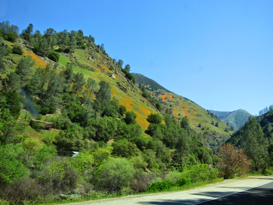
As we drove deeper into the Merced River Canyon, the slopes seemed to come alive in orange and gold. The California Poppies have reached the zenith of their blooming cycle. In contrast to my previous gloom and doom post regarding fires, rejuvenation does indeed occur, as many of these slopes have been cleared of brush and chaparral by repeated wildfires, allowing for dense concentrations of wildflowers.

We passed El Portal, and then the Yosemite View Lodge. The name is not totally dishonest; the boundary of the national park does indeed lie a few yards east of the hotel complex, so the view of the granite slope beyond is indeed a view of Yosemite. But it is not yet the iconic valley with Half Dome and El Capitan and Yosemite Falls. It is pretty, though, and the Merced River makes a dramatic dash through the maze of gigantic fallen boulders.
 We arrived at the park entrance station, drove a few more miles, and made our last stop before Yosemite Valley. It was another site of mass wasting, but this time it was a rockfall, and it included granitic rock instead of metamorphic material. The so-called Cookie Slide took place in 1982, and involved around 100,000 cubic yards of material that bounced and fell down the slope onto Highway 140. Once again, the road was blocked for weeks.
 The size of some of the fallen blocks is astonishing. It's hard to see how a block like the one in the picture below held together during the downhill descent.
The rocks are part of an intrusive series called the El Capitan granite, which was intruded about 103 million years ago. A contemporaneous intrusion of dioritic rock lead to some co-mingling of magmas, including the enclave of darker rock in the granite (below).
I've always thought of granite as a particularly beautiful rock. The sparkling mass of quartz (glassy gray color), orthoclase feldspar (white grains), and biotite mica is pleasing to the eye, and tells an odd story: Yellowstone National Park, off in Wyoming, sits on top of a huge magma chamber that may one day explode again (but not tomorrow). In Yosemite, we are sitting within a former magma chamber, under the volcano. As such we are exploring the inner depths of an extensive magma system, brought to light by long periods of uplift and erosion.

In a coming post, we'll see how Yosemite looked on Saturday.

Meanwhile, in the Skies Tonight...

$
0
0
Lunar eclipses are always interesting, and they can be shared by most of a planet, unlike solar eclipses that follow a narrow strip of land across the globe. I was a little frustrated tonight because high cloudiness affected the view of the unfolding eclipse, but I did what I could.
I was reminded of one of the greatest teaching moments I've ever had, among them having an earthquake take place while teaching about earthquakes. During one of those moments, I was watching the students intently taking a test on quakes when the room shook. Barely anyone even looked up and I told them to look at the swaying monitors on the ceiling and then told them they all failed for not getting under their desks. The ultimate surprise quiz.

But the truly best night was an earth science class a decade or so ago. I was introducing the course and commenting on the shape of the Earth and the students answered in various versions of round, circular, or spherical. I argued that we were on the back of the turtle. They laughed, but I then asked any of them to prove it wasn't.

Dead silence....

Someone said we have pictures from space. I responded that we had pictures of the Death Star and the Enterprise too.

More silence...

So I was able to take the whole class outdoors and point at the ongoing lunar eclipse and ask them what shape the Earth was casting across the surface of the Moon. None of them said turtle. They were impressed (for once!).
In any case, here are my somewhat clouded shots of tonight's eclipse. Other skywatchers
in areas with clear skies will no doubt have finer shots, but what can I say? It was certainly more fun than the taxes I was working on...


It's way too late to catch the other side, so here is totality, and I'm calling it a night...

One of the World's Most Precious Places, Under the Volcano

$
0
0
Yosemite Valley, hands down, is one of the most extraordinary places on our amazing planet. I have been going to Yosemite National Park three or four times a year for the last quarter century, and I never get tired of spending time there. The thousand square miles of national park that surround Yosemite Valley are incredible, but the valley itself is hypnotic. I would hope that everyone could visit the park at least once, but it becomes something special when you can see it throughout the seasons, in all the different moods of the place.
The mood in the park on Saturday was expectant. The snowmelt has been filling the rivers a little (the drought continues unabated), and the first hints of green are showing up in the meadows and oak woodlands on the valley floor. Snow still lingers in the high country. The Dogwoods are just hinting at the possibility of a bloom. Changes will be coming fast in the next few weeks (and the long dry spell of summer will begin soon; much sooner than we have hoped).
The valley is a showcase for learning about glacial features and glacial erosion, although several aspects of valley scenery are not anything like typical. But if the subject is hanging valleys, Yosemite has no peer.

Big glaciers carve deeper valleys than little glaciers. When the massive Merced River glacier joined the Tenaya Creek glacier (with its spillover of additional ice from the Tuolumne Meadows icecap), the combined force of the two ice rivers produced the deep trough of the main valley, 3,000 feet deep (even deeper if the sediments filling the valley floor are removed). The tributary glaciers in Yosemite and Bridalveil Creeks were much smaller and couldn't cut nearly as deep. Their valley floors were left hanging high above the main valley, and today high waterfalls spill over the edges. Bridalveil Fall (in the pictures above and below) is 620 feet high, nearly four times the height of Niagara Falls, but it's one of the smaller waterfalls in Yosemite Valley.
Yosemite Falls is usually described as the highest waterfall in Yosemite Valley, but that depends on which geographer one is arguing with. It has three sections, an upper fall with a drop of 1,425 feet, a cascading central section, and a final sheer drop of 300 feet. It may the fifth or the seventh highest water in the world, but if one is talking about essentially unbroken drops, it's not even the tallest waterfall in Yosemite Valley. That honor goes to Ribbon Fall, shown in the photo below. It drops 1,612 feet, nearly 200 feet more than the upper section of Yosemite Falls. I imagine some first-time visitors mistake it for Yosemite Falls as it is seen first during the drive into the valley. Most people never see it at all though, because it dries up by late spring in most years.
I started up the valley trail from Bridalveil Falls, and ended up with a new view I have not seen before. The trail winds along the base of the Cathedral Rocks, with a sheer precipice of thousands of feet. Being at the base of such high cliffs is awe-inspiring.
Half Dome gets all the attention, but North Dome is beautiful in its symmetry as well. It stands across from Half Dome on the other side of Tenaya Canyon. And it's a whole dome!
And then there is Yosemite Falls. It never fails to amaze me with its stunning drop of nearly half a mile, and it becomes even more amazing when one realizes that it is misplaced in a manner of speaking. Can you see the cleft in the shadows to the left of the waterfall? The cleft provides a route for the trail that climbs up to the top of the waterfall and nearby Yosemite Point.

The dark cleft used to be the path of Yosemite Creek! The falls used to be an inconsequential side canyon but the glacier coming south from the high country pushed up a moraine, a pile of glacial debris, and blocked the normal channel of the canyon. The stream's new pathway took it over the brink of the cliff.
I mentioned the term "under the volcano" in the title because when you stand in the bottom of Yosemite Valley, you are within the frozen magma chambers of a series of volcanoes that once existed here, just five miles or so above. There are eight or nine individual intrusions that make up the valley walls and different susceptibility to erosion has caused the formation of a series of reentrants and coves along with the bold battlements of cliffs like the Cathedral Rocks or El Capitan. Many glacial valleys have long monotonous walls that aren't nearly as appealing a place as Yosemite.

Yosemite is indeed one of the world's most precious places, and I am forever appreciative of living nearby, and being able to share it with you. Enjoy!

Out of the Valley of Death and into an Upside Down Mountain

$
0
0

The Grapevine Mountains form the eastern margin of the Death Valley north of Stovepipe Wells, reaching elevations of nearly 9,000 feet in places. It's an imposing range, stark, barren, and rugged. All of the mountains of Death Valley are rugged pretty much by default, but erosion has not pierced deeply into many of them. They're too young geologically to have been affected much by mudflows and flashfloods in this arid environment.

There are exceptions to everything though, and there is a canyon that practically cleaves the Grapevine Mountains in two. It's called Titus Canyon, and it is spectacular. It certainly is not a secret, and one of the great adventures of visiting Death Valley is to drive the 26 mile long gravel road through the Grapevine Mountains. Literally through the mountain, not over it. The pass at the upper end is on the east side of the mountains, not at the crest.

In places, the canyon reaches depths of 3,000 feet or more, and the steep canyon walls offer unparalleled exposures of the faults and folds that from the structure of the mountain range. As can be seen in the diagrams below, the structure is complex.

The "upside-down mountain"? The rocks of the Bonanza King Formation that are exposed in the lower canyon have been so completely folded that they are inverted. Even though the layers look only gently tilted, they are in fact upside down.
Source: California Geological Survey and National Park Service

The road through Titus Canyon is sometimes okay for normal sedans, but conditions can change, and there are rough spots. We didn't have the time to do the entire one-way journey (from east to west), but it is permissible to drive from Death Valley to the entrance of the canyon and walk into the narrows where the canyon is deepest and darkest.

We did just that on our February visit to the Valley of Death and started hiking up canyon. In places the canyon is only 20 feet wide with vertical walls. Evidence of severe floods was evident everywhere in the form of smooth polished surfaces and pockets of debris tens of feet up on the canyon walls.

The Bonanza King Formation is mostly composed of limestone or dolomite, a carbonate rock that was deposited in warm shallow water in Cambrian time just over 500 million years ago. This was not long after complex life forms first appeared on the planet, and the fossils found within the formation reflect the strangeness of the time. Most of the hard-shelled creatures were a type of arthropod called a trilobite. They resembled a cross between the Horseshoe Crabs found in today's seas, and the roly-polies that can be found in your backyard.
There are few fossils found in the Bonanza King exposures at Titus Canyon. This is a trilobite carapace from the Carrara formation at Emigrant Pass, east of Death Valley National Park.
The trilobites were extremely diverse, filling many environmental niches in the early Paleozoic seas, and they lasted for several hundred million years as a group, but by the end of the Paleozoic era they were extinct, losing out in competition with other arthropods like crabs or lobsters. Some good samples can be found in mountain ranges east of Death Valley National Park.

A mile or so up the canyon one encounters a creepy old guy standing next to the rock a fascinating exposure of broken up limestone called a megabreccia. It looks like evidence of severe geological mayhem, but was probably the result of slowly evolving deformation and cracking of the rock over millions of years of incremental folding. As cracks in the rock slowly widened, they were filled in with calcium carbonate carried in the groundwater.

In the photo above one can see the efficient manner in which flash flooding has kept the outcrop clean and visible. There is a tight turn in the canyon just downstream along with an alcove produced by mudflows impacting the canyon wall and making a sharp right turn.
We started back down the canyon taking in the incredible sight of the Cottonwood Mountains through the narrow slot canyon. It's a fascinating place to explore. As we emerged from the canyon onto the top of the alluvial fan for Titus Canyon, we had a wide-ranging view of northern Death Valley, with the Panamint and Cottonwood Mountains in the distance with the Death Valley dunes on the valley floor.

We got back in the vans and headed towards the Black Mountains. We were about to encounter Dante's View...

Vernal Fall in Yosemite and a Sense of Scale (or, How to Feel Very Small)

$
0
0
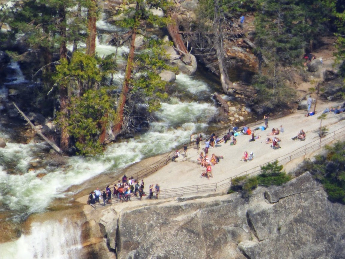
It's a sense of scale that helps us keep perspective. I was at Washburn Point in Yosemite National Park today, and I took a few shots with the zoom of the same spot across the way.

We have a bunch of people apparently enjoying themselves on a flat slab of rock next to a fair sized river. But why the fence? Why aren't they letting people cool their feet in the river on this reasonably warm day?
Maybe it is the fact that they are standing at the top of a 318 foot (97 meter) waterfall. And a hell of a dangerous one. It is far too easy to miscalculate just how powerful a flowing river can be. Water only a foot deep can easily knock you off your feet, and the rock can be exceedingly smooth from glacial erosion and slick with algae. Too many people on the wrong side of the fence have lost their lives.
As we pull back even more, we can see the full extent of the waterfall, and the insignificance of the people gathered around the brink. They are now barely visible. This is Vernal Fall on the Merced River just upstream of Yosemite Valley. It formed because the glaciers that once flowed through the valley plucked away at highly jointed rocks forming what is called a glacial stairstep. It is just one of many spectacular waterfalls in Yosemite that leave one feeling awestruck.
And yet, Yosemite is such an incredible landscape of gigantic granite domes and deep glacially carved gorges that even a 318 foot waterfall can almost be lost in the richness of scenery. As I noted before, I was on Washburn Point, about two miles away as the crow flies (or more probably the raven, given their abundance here) from Vernal Fall. In the picture below, Vernal is the smaller of the two gigantic waterfalls. The upper one is Nevada Falls, which drops 594 feet (181 meters). 

To the left of Nevada Falls is Liberty Cap, a glacially smoothed granitic dome. To the left of Liberty, the dark rounded form of Half Dome is seen from an unfamiliar angle. From this angle it is clear that if anything, it should be called Three-Quarters Dome, or even Four-Fifths Dome. 

Half Dome was never covered by glacial ice, and was formed instead by exfoliation, the tendency of rocky monoliths to break off slabs of rock as the pressure is released as the rock is exposed at the surface. The slabs mostly remove corners and edges, giving the rock a rounded profile. The steep face of Half Dome was a prominent joint, a vertical crack that also forms from pressure release. The "missing" half was undercut by the glacier below in Tenaya Canyon and quarried away down the valley.

Feeling small yet?

The Dogwoods are Blooming in Yosemite Valley! And North Dome, the Stuff of Legend

$
0
0
The Pacific Dogwood (Cornus nuttalli) is a diminutive tree that forms some of the understory of Yosemite Valley's conifer forests. It seems practically invisible to park visitors (like me, anyway) most of the year except for two times: fall, when the tree becomes one of the most vivid contributors to the autumn colors of the valley, and spring, when the Dogwood flowers bloom. The flowers aren't all that showy actually. They are the small yellow sphere in the middle of the structure. But they are surrounded by large white bracts that look like flower petals. Bracts are actually highly modified leaves. Just the same, they add a bright splash of white to the forest understory in the spring. I was in Yosemite Valley just a week ago and I would swear there were no Dogwood blooms at the time, but there were many of them yesterday.
Of course this is mostly a geology blog, so I couldn't help but notice that I was using North Dome as a backdrop to the blooming trees. North Dome is one of the less heralded sights in Yosemite Valley, a place with so many gigantic cliffs and waterfalls, that otherwise spectacular features get lost in the shuffle. It sits to the east of Yosemite Falls and across Tenaya Canyon from the much more famous Half Dome. It is a marvelous example of an exfoliation dome, which developed as the rock was exposed by erosion. The granitic rock, which formed miles deep in the crust, expanded as it reached the surface and the rock slabbed off, removing the corners and edges and forming the spherical outline (although from above it is a more linear ridge).

According the writings of Galen Clark, North Dome is tied in with Half Dome in the mythology of the Native Americans who inhabited the valley. It is called To-tau-kon-nu'-la, referring to the cranes that could be seen around the base. Half Dome, across the canyon is Tis-sa'-ack. According to one version of the story, the great chief Choo'-too-se-ka', whose name was later changed to To-tau-kon-nu'-la after he built is home on the dome, fell in love with the woman Tis-sa'-ack who hadcome out of the south to help teach the people to weave beautiful baskets. She did not return his love, saying she needed to return to her people, and she left in the night. The chief set out to search for her and never returned, leaving the people behind to suffer droughts, floods, rockslides, earthquakes and other calamities. One of the earthquakes caused Half Dome to split and half of it fell into the valley. Eventually the Great Spirit had mercy on the remaining people and returned the land to a bountiful state. An image of Choo'-too-se-ka/To-tau-kon-nu'-la appeared on North Dome, and Tis-sa'-ack is visible on Half Dome.

There is a second story about quarreling spouses that I don't like as much...

Of course those old myths don't reflect reality...like rockfalls, floods, and earthquakes. They never actually happen in Yosemite, right? Oh...
Half Dome and the Ahwiyah Point rock fall of 2009 (center)

Where are the Ten Most Incredible Places You've Ever Stood? A New Blog Series...

$
0
0

What is the most incredible place you have ever stood? That thought occurred to me this last weekend when I got up to Glacier and Washburn Points in Yosemite National Park. For those who are less familiar with the park, Glacier and Washburn Points are on the rim of Yosemite Valley, not on the valley floor. As such, they give a bird's-eye view of one of the most incredible pieces of land in the world, and though a million or more people may stop there during their visit to Yosemite, I'll bet the majority of park visitors don't venture up that way. It's something like 20 winding miles outside of tourist central on the valley floor, and perhaps hard to squeeze in when trying to rush through the park in the limited moments afforded by a vacation.

Is the high point on the rim of Yosemite Valley the greatest spot I've ever stood? I'm not sure yet! This is the opening salvo of a new series called the Ten Most Incredible Places, and I'm going to decide number one somewhere along the way before I finish. I'd also like you to consider what your own most incredible places are. I'd love to have you share them, perhaps in your own blog if you have one, or share them in the comments here. I'd be glad to post a few of your wonderful pictures as I consider my list. Be sure to include some reasons why a particular place stands out, whether geological, biological, spiritual, or personal.

I'm looking forward to seeing some incredible places!

Where are the Ten Most Incredible Places You've Ever Stood? My Number 10: The Alaka'i Swamp on the Island of Kaua'i

$
0
0
It is Earth Day 2014, which seems as good a day as any to start a new series about ten of the most extraordinary places on Planet Earth, as based on my own personal experiences. Everyone has such places in their memories, and I encourage you to add your most profound experiences in the comments or on your own blog if you have one. Mine aren't necessarily the most extraordinary places in the world, seeing as how I haven't and will never see every such place, but that's why I want to hear from you. We only have so much time on our beautiful planet, and I'd like ideas of where to head next!

My list is not in a precise order. Listing a favorite among these is tantamount to selecting which of my children I love the most. I am saving my most precious for number one, but aside from that, these are all equally incredible. I've not made any rules about these sites; some required long hikes, others I drove to. Some are all about the geology, some are about other things.

So what is this place today? It's cold, it's wet, it's made up mostly of waist-deep mud, and basically the last kind of environment that one would ever thinks exists in the state of Hawaii. Where are the palms and sandy beaches?

They are about 4,000 feet and a world away.
On the island of Kaua'i, some of the preconceptions of Hawai'i fall by the wayside. There are numerous examples of iconic coral sand beaches and offshore reefs. But there is also a deep gorge that has been called the Grand Canyon of the Pacific (Waimea Canyon), which almost made my top-ten list. But there is a region on the island that is practically unique to the world: a high altitude swamp and rainforest complex that is one of the wettest places on the planet. It's called the Alaka'i Swamp, and it is part of the Waialeale Plateau, a place where the average yearly rainfall is close to 40 feet. In 1982, 683 inches of rain fell. That's 57 feet!
A friendly 'Elepaio in the Alaka'i Swamp
So much rain falls on the high plateau that plants can't grow into mature forests. Some areas only seem to grow moss.  The mud is so deep that one has to wonder how one can explore this strange environment without getting hopelessly stuck. Luckily the state of Hawai'i has seen fit to construct a boardwalk that on the one hand provides safe passage for hikers, and on the other keeps people out of sensitive areas of the plateau. Because it's not just a strange environment. It's also one of the last stands for the native species of the Hawaiian Islands.

The native birds of the Hawaiian Islands provide a laboratory for the study of evolution no less significant than Darwin's Galapagos Islands. But the birds are under siege. Numerous invasive bird species came with the humans, along with wild pigs, mongooses, and malaria-bearing mosquitoes. Few birds seen by tourists are actually natives. The natives survive mostly at elevations above 3,000 feet where the mosquitoes can't thrive. Of the original 71 known species of birds on the Hawaiian Islands, 24 are extinct, and 32 are severely endangered. They've lost out to competition, habitat loss, disease, and predation (by the mongooses, which are as common as squirrels in the urban parks on the islands). Mongooses were never introduced on Kaua'i, so the higher parts of the island are the best places to see the rare natives like the 'Elepaio in the picture above (other birds are much rarer, but this was the only one I saw on my hike).
In 2009 I had the privilege of hiking the 5 mile trail (one-way) to Kilohana Overlook. It was one of the great adventures of my life. The trail began at the Na Pali Overlook and parking lot. The first mile was on a usually closed paved road to a second overlook. After that it was up and down on some potentially muddy trails, but we lucked out and didn't get rain that day. Eventually we were walking through the deep 'Ohi'a forest.

'Ohi'a trees are endemic to the Hawaiian Islands, and are one of the most adaptable trees on the planet, capable of growing on barren lava flows in near-desert conditions at sea level to cold, almost alpine conditions at 8,200 feet. The trees have beautiful red flowers that look like small red fireworks exploding from the branches.
The flowers are called "Lehua", and they figure prominently in Hawaiian mythology. The tree was a handsome young man, 'Ohi'a, who spurned the attentions of Pele, the volcano goddess. He was in love with Lehua instead. In a fit of anger, Pele turned the young man into a tree, but later repented and adorned the trees with his beautiful lover, the Lehua.
When we climbed onto the high plateau, it got...weird. Just low brush and ferns, with mud everywhere. We were fortunate the rain wasn't pouring on us by this point.
In the distance on this extraordinarily clear and sunny day, we could see the slopes leading to the high point of the island at Mt. Waialeale. Part of me wanted to leave the trail and explore the strange wilderness off to the south, but I knew I would be up to my knees or worse after the first few steps. We kept to the trail!
Mud was now everywhere, enough to creep us out a little. This is an environment almost entirely alien to humans. We were now getting close to the end of the trail at the Kilohana Overlook. It's not a good idea to have the view from the Kilohana as an ultimate goal for hiking the trail. Most of the time, the overlook is bathed in clouds. I hiked to the edge and looked into the abyss below.
It was clear! We could see deep into the canyon of Waihina River gorge. I don't think I've ever seen more inaccessible slopes. Impenetrable slopes choked with rainforest vegetation, and not even a hint of a trail. Leaning over the edge, it was hard to tell where the soil ended and the vegetation began.
Down in the distance was the gorgeous bay of Hanalei, 4,000 feet below us. We were at the top of the Wainiha Pali (cliff) in one of the prettiest places I had ever seen.

The skies were fickle, though. Hardly ten minutes passed by and the clouds closed in for good. Some of our party arrived a few moments later and never saw a thing. It was okay though. The overlook was icing on the cake for the strange beauty of a hike through one of the strangest worlds I had ever seen.


Where are the Ten Most Incredible Places You've Ever Stood? My Number 9: Frame Arch and the Delicate Arch Trail

$
0
0
It's the journey through the Ten Most Incredible Places I've Ever Stood! As I explained in the last post, the list is subjective, and everyone's list will be different. I'm pleased at the response of many of you already listing your most incredible spots in the comments, and on my accounts at Facebook and Google+. I'm looking forward to seeing more! My own list is not in any particular order, other than my choice for number one. Folks will perhaps not be surprised to see that I selected the picture above for my number 9; it's the cover photo from my Geotripper Images website where I've posted a lot of my geological pictures for use in educational/academic projects. It is a view of the La Sal Mountains through Frame Arch at the end of the Delicate Arch trail in Arches National Park.

In the years before PowerPoint, I started all of my geology classes with a set of slides (this was an ancient technology that involved "carousel trays", "slide projectors", and "film") to introduce the students to the world as it is revealed by geological processes. The first picture was always this stretch of trail just short of  Delicate Arch. I chose it because it symbolized so much about the wonders revealed in the incredible history of our planet.
The trail is cut into a formation called the Entrada Sandstone, a layer composed mostly of  windblown sandstone as well is silt and mud in some areas. It once was a system of sand dunes near a coastal delta and estuary during the Jurassic Period around 140-180 million years ago. The trail surface is a natural separation along the surface on one of the dunes, so by walking on this trail we are striding on the same surface that dinosaurs, ancient mammals, and arthropods walked on many millions of years ago. We know that these rocks were buried deeply by thousands of feet of overlying rock, but they were pushed upwards by vast salt domes rising from older formations below. The doming effect split the rocks into linear fins, and the arches developed from weathering and erosion at the base of fins.

At one viewpoint an observer can appreciate the variety of depositional environments that led to the formation of the colorful Entrada rocks, the vast amount of time that the rocks lay buried in the crust, the immensity of earth movements that brought the rocks back to the surface, and the intensity of erosional processes that shaped the rocks into what they are today. And one can walk on a surface that may very well have been a trackway for a dinosaur many eons ago.

But (like they say in late-night television ads), there's more! Although many people use Frame Arch to frame Delicate Arch, I chose to emphasize the La Sal Mountains instead (the top photo). The La Sals represent the role of magmas in earth processes. The mountains are composed of intrusive rock that reached close to the Earth's surface about 25 to 28 million years ago. Some may even have erupted out in volcanic eruptions, but the rest of the rock formed into mushroom shaped plutons called laccoliths. The dioritic rock proved more resistant to erosion than the surrounding shale and sandstone, so the peaks rise 6,000 to 7,000 feet above the plateau surface. The highest peaks in the La Sals reach nearly 13,000 feet above sea level.
It's a scenic, even iconic spot for photographers and park visitors, but what makes this one spot special to me? It's the unique experience of each visit. It's been my privilege to visit this spot perhaps a dozen times in the last 30 years and every time it has been an awe-inspiring journey. We usually head up the 1.5 mile trail in the late afternoon in order to catch the sunset on Delicate Arch. Quite often there is a raucous crowd, and some moron always feels a need to go stand under the arch for an inordinate period of time, prompting shouted complaints from the large group of photographers on the ridge top. Frame Arch becomes the special spot at that point because there is only myself and a few of my fellow travelers. We don't hear the chaos and mayhem at Delicate Arch, and we can just sit and appreciate the changing colors and deepening shadows.

Once or twice we've been doused with a summer rainstorm, and in one particular year we took shelter under the arch and gloried in the lightning and crashing thunder, and watched as the dry sandstone transformed into a series of waterfalls and white cascades. It was one of the most cherished moments of my life. We assumed that the storm would obscure the sunset, but as quickly as the storm hit, it dispersed and the sunshine broke through to highlight the La Sal Mountains in the far distance.


One more reason that this spot is on my incredible list is because of the ephemeral nature of Delicate Arch itself. It may not last my lifetime. The arch is only a foot and a half thick at one point, and there are valid fears that it could collapse in the natural order of events. Of course, humans may help it along; I've heard of at least one episode in which a man attacked the arch with an axe. Then again, it could last another thousand years. Who knows? In the meantime it is a magic place.

Once before I pass on I would like to see it in the snow.

Where are the Ten Most Incredible Places You've Ever Stood? My Number 8: The Burgess Shale in British Columbia

$
0
0
The journey continues through the ten most incredible places where I've ever stood. Every person's list will be different; I'm hoping to hear of great ideas for future travels! Number ten for me was the Alaka'i Swamp of Kaua'i. Number nine was Frame Arch in Arches National Park next to Delicate Arch, Frame's better-known counterpart. This next one was an easy post because one of the Accretionary Wedge topics asked a similar question, i.e. What is your geological pilgrimage – the sacred geological place that you must visit at least once in your lifetime? What follows is a slightly abridged post from the wedge topic in April of 2012. Keep in mind that no order is implied with these posts, except for number one.

I've had a rich life, being able to link my favorite activities, traveling and photography, with my career as a geologist and teacher. It means I have been to a lot of places, so determining a list like this leads to a lot of introspection. I've been enjoying reading some of the other entries...I like new ideas of where to go!

I settled on this one particular site because of the emotional impact it had when I reached the goal. It was indeed remote and difficult to get to. It was the Burgess Shale fossil quarry in Yoho National Park in British Columbia, Canada. Besides being one of the most important fossil sites in the world, it involved one of the most beautiful hikes I've ever taken. Just look at the scenery from the edge of the quarry:
Fossilization is a chancy process. Everything has to happen just right, and most of the time organisms are immediately scavenged or quickly decay. Even when things happen just right, it is exceedingly rare for anything besides bone or shell to survive. As a result, the fossil record is highly biased towards creatures with shells. When one considers how many soft-bodied creatures exist in the world's ecosystems, and how rarely they are preserved, we realize how poor our picture of the past really is. This is especially true of the "dawn" of complex life in the Cambrian period, just over 500 million years ago. Something 75% of the record is made up of the various species of trilobites, and most of the rest are sponge-like archaeocyathids and brachiopods (simple bivalved creatures which are not as "advanced" as clams). Although we know that plenty of soft-bodied forms existed, they have not been preserved, except in a precious few places.

One of these is the Burgess Shale, in British Columbia. The shale accumulated as masses of mud slid into oxygen-poor water. The organisms living in the environment were killed immediately, as were the scavengers and microbes that would have consumed them. The outcrops were discovered by Charles Walcott in 1909, and over the years tens of thousands of specimens have been collected and analyzed. The rocks were full of diverse and sometimes bizarre species that would have otherwise been lost to all time (see this article for examples).

The Burgess Shale is high on a ridge in the Canadian Rockies, and it is a tough six mile hike to the quarry. As a World Heritage Site, and being within a Canadian National Park, access is highly restricted (and believe me, they know when someone is there illegally!). To see the quarry one must go with a conducted tour through the Burgess Shale Geoscience Foundation.
I made the hike in July of 2005, one of the first hikes that year in this cold alpine environment. The sun played hide and seek with the clouds, and rain occasionally threatened (I have the distinct impression that that situation occurs just about every day up there). Glacier Lilies were everywhere, providing a great deal of color along the trail. There were also several steaming piles of grizzly bear poop, so we stayed pretty close together on the trail...
It was a long uphill hike, but after 5 1/2 miles, we passed a sign that let us know we were drawing close.
I walked a little slower than the others, and I paused at the last few steps. Most of the other hikers were not geologists, and were only beginning to understand the importance of this site to paleontology. I gathered my thoughts and emotions, and stepped into the quarry for the first time.
It was still half-filled with snow and ice, but there were plenty of slabs of rock around. Trilobites were all over, and I almost immediately found a delicate sponge fossil. The others gathered at the far end of the quarry, so I walked over.
The foundation knows that random searching in the quarry will not reveal some of the rare creatures, so they keep some pretty decent samples in the red lockbox on the site. Gazing at the specimens, I realized all over again what a wondrous treasure this site this really is for paleontologists.
Collecting of course is not allowed here, but we were allowed to search among the slabs for fossils that we could "own" for ourselves through the magic of digital imagery. I quickly found a nicely preserved Haplophrentis, a primitive mollusk related to snails and clams.
My favorite find was a complex little Marrella species, which is actually the most commonly found fossil in the Burgess Shale. It was the most delicate fossil I've ever found. And hard to photograph!
I tried photographing the fossil from a couple of angles. The brown spot is a stain of fluids that escaped when the organism died. In case you are wondering, no, the specimen didn't "accidently" fall into my pocket. I put it in the pile next to the big red box, so look for it if you ever get up that way.
If you are having difficulty making out the specimen in the pictures above, check out the reconstruction in the picture below to get an idea of the complexity of the little creature. Something close to 180 species of creatures have been found in the shale, and perhaps only 2% would have been preserved in Cambrian sediments anywhere else in the world. The fossil record certainly has a bias that favors animals with hard shells or skeletons.
Marrella splendens Source: http://burgess-shale.rom.on.ca/en/fossil-gallery/view-species.php?id=80&m=3&
The rain started to fall, so we started down the barren slope. It's not a very smart place to be in a lightning storm! During the hike down, I was no longer so anxious about reaching the goal. I strolled along, enjoying some of the finest alpine scenery I have ever laid eyes on.

Emerald Lake, thousands of feet below, really looked more turquoise in color, due to the fine clay particles suspended in the water. Glaciers are still carving these mountains.
After about ten hours and 12 miles on steep trails, I arrived back at the parking lot, tired but happy. It was indeed a place worthy of a geological pilgrimage, and easily made my top-ten list of the most splendid places I've ever stood.

Where are the Ten Most Incredible Places You've Ever Stood? My Number 7, Gubbio, Italy: Castles, Medieval Town, Roman Arena, Faults, and a Dinosaur Killer

$
0
0
It's not always easy, but travel whenever you can. See as much of the world as possible. I passed on both New Zealand and Hawaii three decades ago for reasons that seem trivial today. I didn't go overseas until 2001, but my life since then has been enriched in ways that I can barely comprehend. Few of us have resources enough to just leave and go somewhere, but there are sometimes cheap alternatives...like a geology field class! Yes, you have to work and stuff, but you will see wonderful things, and you'll be traveling with interesting people.

Number seven on my list of most incredible places is Gubbio, in the Umbrian Province of Italy, between Rome and Florence. What's not to like about Gubbio? It has castles, monasteries, medieval fortresses, Roman arenas, plus active faults and beautiful mountains (the Apennines). Plus one of the most significant geologic outcrops in the world (more on that a moment).
Back in 2007, we conducted a joint anthropology/geology field studies journey through Italy and Switzerland. I had never been to Italy before, so I had a lot of book learning to accomplish before I could lead students in mastering of the geology of the country. And because I had never been there, we had a tour company make the logistical arrangements. They had a canned tour which visited all the famous sites (the Colosseum! the Leaning Tower of Pisa!) and it was sometimes a bit tricky to see some of the important geology (although Pompei was a stunning exception; the trip included a hike to the summit of Vesuvius as well as a tour of the ruins). On the day that we drove from Rome to Florence, there was a scheduled visit to the Basilica of St. Francis of Assisi. 

I suppose that some people would have preferred to see the church, but we had noticed that it wouldn't be much of a diversion off our route to see Gubbio instead. It lies east of the main highway high in the Apennines Mountains, the nearly thousand kilometer range that runs down the boot length of the Italian peninsula. The mountains have risen in response to compressive forces related to a convergent boundary in the Mediterranean Sea. In the vicinity of Gubbio, late Mesozoic and early Cenozoic limestone layers have been lifted high into a mountain ridge. In more recent time, faulting formed the valley containing Gubbio. The downdropped crust is called a graben. The eroded fault scarp above the town is called a triangular facet (much of the town is built on the fault surface; see the top picture). That the faults are still active has been shown in dramatic manner, as several deadly earthquakes have shaken the region in recent decades (one of them severely damaged the Basilica of St. Francis in 1997; the L'Aquila quake in 2009 killed 300 people and resulted in some geologists going to prison).
Gubbio has been a crossroads on the Italian peninsula for thousands of years, and numerous cultures have controlled it at one time or another. Its origin dates back to at least the Bronze Age, and some tablets discovered there contain the most extensive known examples of the Umbrian language. The Romans invaded in the 2nd century BCE, and the Roman theater/arena is the second largest known.
The city became powerful and changed hands often during the Medieval period, being on the main transportation routes of the time, but today it is sort of a backwater town, retaining a great deal of its Medieval heritage, including defensive walls, castles, monasteries and churches. But as interesting as these things were, we were there for something else.

The canyon leading down into the town of Gubbio is called the Bottacioni Gorge, and it cuts deeply into the Cretaceous and Paleogene limestone deposits of the Apennines Mountains. In the late 1970s, the father and son team of Luis and Walter Alvarez were here trying to gain some insight on the rate of extinctions at the end of the Cretaceous period, the mass extinction event that did in the dinosaurs about around two-thirds of the species of life on Earth at the time. They decided to test the marine sediments for concentrations of iridium, an element rare on Earth, but relatively more abundant in meteorites. The values were small, a few parts per trillion, and it was hoped that they might provide data on the rate of sedimentation across the Cretaceous-Paleogene boundary (or the Cretaceous-Tertiary K/T boundary).

They got a big surprise. A clay layer at the boundary exposed in the Bottacioni Gorge spiked at around 3,000 parts per trillion, a huge number. In the years that followed, a similar iridium-enriched clay layer was discovered at numerous sites around the world, and researchers soon suggested that a gigantic asteroid perhaps 6 or 7 miles across hit the planet and ultimate caused the extinction of the dinosaurs and other large creatures.

And here we were, ready to lay our hands on the epic moment recorded in the rock when the way was cleared for mammals to take over terrestrial ecosystems on planet Earth. Except there were a few minor problems. For one, we didn't exactly know precisely where it was. And we didn't know if the spot would be marked or if there would be room to park a bus. And though it seems a minor issue, there were 35 people on the trip, and we didn't know where we were going to eat lunch (as all field trip veterans know, the two most important issues are "where and when do we eat?" and "where is the next bathroom?"). I had figured out that the spot was about 2 kilometers upstream from Gubbio, and that there was some kind of old medieval water canal close by.
So I was on pins and needles watching for the outcrop. The first problem cropped up on the edge of Gubbio. The sign on the road quite clearly said "no buses". Our Italian bus driver solved that problem in fine Italian style by ignoring it and driving right on past. We headed up the gorge, rounded a bend, and there was the canal, but I noted with a sinking heart that we had already passed the outcrop on the narrow road, which was pretty much not appropriate for buses (which is what the sign said, I think...). We drove for an interminable number of kilometers up the canyon (I figured about 80 kilometers, but the reality was probably 10), where the driver found a pullout that might be big enough to turn the bus around in.

Those of you who've seen the Austin Powers chase scene where he has a bit of trouble turning a golf cart around will appreciate what our bus driver did on that mountain road with a narrow pullout and a steep canyon wall. This wasn't a Y-turn. This was a Spiro-graph turn, for those of you who remember that toy. Back and forth for what felt like an hour, but was probably more like five minutes. But it finally happened and we headed back down the canyon.
The outcrop containing the iridium layer was in fact marked with a metal placard and an interpretive sign. We gathered around to have a look.
It was not unexpected I suppose that there would be precious little of the clay layer left at the site. Souvenir hunters have produced a huge cavity in the rock, but still, it was a great moment to lay one's hand on the surface where by most accounts, the dominance of the world by the dinosaurs ended. Medieval stories abound of brave knights sallying forth to slay dragons, but it seems the deed was done some 65 million years before we arrived on the planet.
One could see the drill holes left in the rock by the researchers. It is amazing that such a modest outcrop could contain a few atoms of a substance that could reveal a clue towards solving one of the greatest mysteries of the geologic sciences.
Now about the lunch and bathrooms issue. We had been driving for hours and people were getting hungry and, um, uncomfortable. It turned out that there was a single business in the Bottacioni Gorge, but it happened to be a restaurant, and the owner was quite happy to have a crowd of hungry geologists descend on his establishment. He's been catering to geologists for decades as it turns out, enough so that we were asked to sign the geologists register that was first signed by the Alvarez and his assistants!

And the food? By all accounts, the pasta and mushroom dish was the finest lunch we had on our entire journey. It was delicious! If you ever have the chance to visit the Gubbio locality, plan on eating at the Ristorante Bottacioni.


The Antelope Valley California Poppy Reserve: Color in the Western Mojave Desert This Week

$
0
0
I admit I've taken artistic license, in that I took this picture of a busy hummingbird on the same day, but by the time I took the shot, I was two hundred miles north in the parking lot of a Black Bear Diner in Tulare, California on my way home. But it sure catches the eye, doesn't it?
We were in Southern California for the wedding of my god-daughter this last weekend (have a great life Megan and Richard!), and I must say they picked a good time to give us an excuse for hitting the road. On the way home we made our way along the San Andreas fault from Cajon Pass to the Grapevine, hunting for earthquakes, and hoping to see some colorful wildflowers, despite California's crippling drought. A drought, yes, and a huge water deficit, but we had a few good storms roll through the state in the last few weeks, giving a boost to the wildflower season.
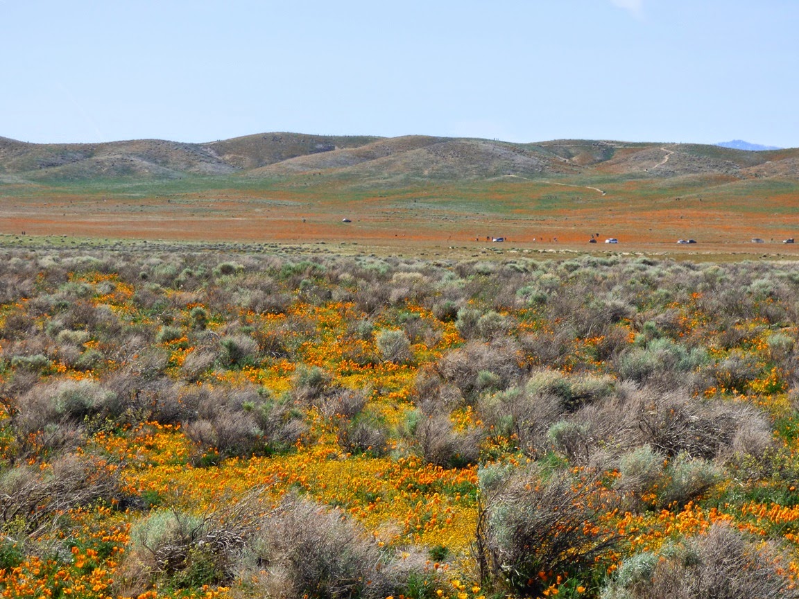
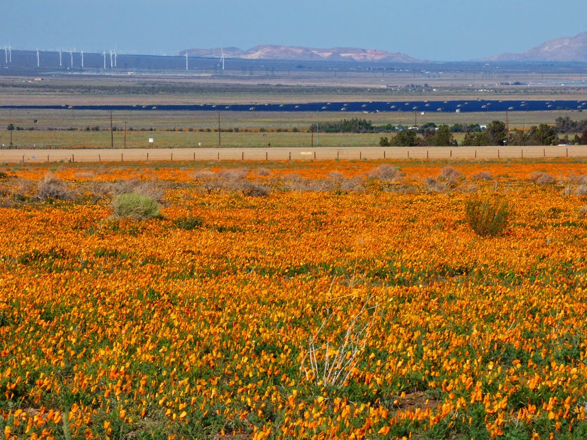
We took a chance and headed out the Antelope Valley California Poppy Reserve to see if the poppies were blooming. They were. They are certainly a bit more limited in scope than in wetter years, but they formed a beautiful golden carpet across the desert floor. They were also mostly closed up in the fierce wind that was blowing through the area in the aftermath of the storm. The poppies are natural, but exist here for an unnatural reason, a topic I discussed back in 2010 in this post.
In that post I described how.the flowers are a natural phenomena, but a natural phenomena with a very human influence. About seven miles west of the Poppy preserve there is another state park: Arthur B. Ripley Desert Woodland State Park. The park preserves 580 acres of what turns out to be the native land cover of the Mojave Desert west of Lancaster and Palmdale: juniper woodland and Joshua Trees.

A century ago, this high end of the desert was cleared of Joshua Trees and Juniper, usually by chaining (dragging a huge chain between tractors that knocked down whole forests) or fires in order to put in thousands of acres of alfalfa fields and other crops. Large areas were reserved for sheep and cattle grazing as well. The natural plant cover was long gone. Much later, some of the abandoned fields started to recover, and the showy wildflowers are the pioneer species that are the first to recolonize disturbed lands.  Joshua Trees can no longer recolonize the valley floor; they don't have any method to spread their seeds widely (Joshua Trees were once spread in giant ground sloth poop...). Despite their incredible beauty, the wildflower displays are a monument to our extensive alteration of the environment that once existed here.

Many of the agricultural fields have been abandoned for lack of water and other economic reasons, but our utilization of the desert for our human needs continues. Notice in the picture below the huge windmills in the distance, and what I think is a large solar array.
After taking in the beautiful fields of California Poppies, we headed west along the San Andreas fault to Highway 138 and the Gorman cutoff. Suddenly the hills were alive again with what looked like the beginning of a nice blooming of lupines and some kind of yellow flower (we didn't have time to stop and investigate closely).
I imagine that in a week or so this will be a true wonderland of color, especially after the weekend dousing by the short but intense storm that rolled through California. The storm was too late to do anything about the drought, but it brightened the world just a little before the summer heat sets in.

Adventures Along California's San Andreas Fault: The Devil's Punchbowl (but no earthquakes today)

$
0
0
The Devil gets blamed for a lot of stuff, and who am I to say he isn't responsible for bad things? But one can hardly blame us for blaming him for massive earthquakes when he goes around leaving things next to major fault systems, like punchbowls.

Southern California is a tortured landscape, and it isn't just the pop culture. The entire region has been twisted more than 90 degrees from its original orientation, forming one of the very few east-west trending mountains ranges in North America. The rotation is a consequence of the crust being caught between the Pacific and North American plates along the San Andreas and related fault systems. The end result of the rotation and stepwise motion of the fault is massive compressional forces that have lifted the San Gabriel and San Bernardino mountains to great heights in a very short period of geologic time, just a few million years.
The San Andreas fault shifts sideways with the consequence that long ridge lines called shutter ridges offset stream channels and block drainages. The two foreground ridges run parallel to the San Andreas along the north side of the San Gabriels.
Our journey home this last weekend followed the path of the San Andreas fault as it passed along the north side of the rugged San Gabriel Mountains. These mountains are statistically one of the steepest mountain ranges on the planet, and the huge number of ancient and modern landslides in and around the mountains attests to their instability. The deformation of the crust is most intense in the immediate vicinity of the fault zone, so we encountered a mess of rocks when we arrived at Devils Punchbowl County Park outside the town of Pearblossom.
Devils Punchbowl is administered by the county of Los Angeles, and has a nice little visitor center with a couple of interesting trails that wind among the steeply dipping rock layers. The rocks exposed in the park are called the Punchbowl formation, and they were deposited in alluvial fans in basins that formed about 13 million years ago in the vicinity of the fault. They have since been twisted into a series of upward (anticlines) and downward pointing folds (synclines). The map below by Thomas Dibblee, a legendary California geologist, shows the generalized geology of the Devils Punchbowl region.

The axis of the most obvious fold in the main part of the park, a syncline, plunges into the ground to the west directly towards the park headquarters. It's on the map above and in the picture below:


If it is hard to pick out, take a look at the annotated picture below. In a syncline, the layers slope, or dip, towards the center (the axis) of the fold. The axis slopes towards the observer, i.e. water would tend to flow downwards along the axis of the fold.
A popular one-mile long loop trail winds through the center of the punchbowl, offering some nice views of the conglomerate and arkosic sandstones that make up the cliffs. I had a few moments to spare, so I walked quickly down the trail to have a look around (I moved considerably slower on the climb back up!).
If these rocks look a little like a place where Captain Kirk should be fighting Gorns, you aren't too far off, although it's a different formation, a different fault, and a different location. The Vasquez Rocks are along Highway 14 on the other side of the San Gabriel Mountains, but the rocks there also formed in alluvial fans, and were tilted by fault motions.
The trail started to climb steeply, and I realized that all my walking exercises over the last five months have done wonders for my leg muscles, but somewhat less for my aerobic capacity. I've got to spend more time on stairs! As an old favorite folk song says, I'd rather be huffing than not huff at all.
The Devils Punchbowl is a fascinating place to visit. You access the park from a turnoff at the east end of the village of Pearblossom on Highway 138 between Palmdale and Cajon Pass. There are picnic facilities, but no camping. The kids will love Squints the owl and the other animals in the visitor center.

Geologists sometimes seem to court disaster, in the sense that someone like me will stand on a major fault zone and think to himself that it would be cool to see the "Big One" happen just then.  Such an event is going to be a horrible tragedy, and I would never wish it on anyone, but we live here in California, and the quakes do happen. It's just that there is an intellectual curiosity about what it looks like when a fault ruptures and shifts 15 or 20 feet. It would indeed be a sight to see.
So we hung around near the fault trace just to see what would happen. Nothing did, of course, or everyone would have heard of it. The big earthquakes have a recurrence interval of around 100-150 years, and with the last major event in 1857, there is plenty of stress built up, but there was no compelling reason to think that it would happen while we were there. No, we just heard the light breezes, the buzz of busy insects, and watched the sun shining on myriads of wildflowers hiding among the shrubs.
We stooped down and started photographing flowers, including this one, a variant of the Mariposa Lily that I was not familiar with. It's stunningly beautiful, but if you are a small bug, it can be deadly as well, as you can see in the photo below...
There were just a few Beavertail Cacti blooming in the area.
There were lots of Coreopsis growing in isolated patches.
And there were lots of Desert Dandelions along the highways where they benefited from the little bit of extra runoff from the road surface.

All in all, a beautiful day, courtesy of the Devil leaving his punchbowl lying around a major plate boundary.

Where are the Ten Most Incredible Places You've Ever Stood? My Number 6: I stood in a place no one else can ever stand, at Pu'u O'o

$
0
0
Yes, Hawai'i gets two spots on my top ten list of the most incredible places I've ever stood. A few days ago I talked about my wonderful adventure in the swamps of the Alaka'i Plateau on Kaua'i, but today we'll hear about the Big Island, and the rather incredible volcano there that has been erupting continuously now for thirty-one years, since 1983. The ongoing eruption of Kilauea and its satellite vent Pu'u O'o is the longest known period of activity in the history of the volcanoes of Hawai'i.

It was June of 2002 when I reached the Hawaiian Islands for the first time in my life. I had spent the first fifteen years of my academic career learning to teach and ignoring any kind of writing or research, but I finally decided to submit an abstract and give a presentation at a meeting of the American Association for the Advancement of Science on the Big Island. I anxiously watched the lava flow reports for months ahead of time, but little was happening with the volcano. It was essentially a time of simmering around the summit region of Pu'u O'o, and any chance of seeing active lava flows would require miles of hiking over practically impenetrable forest and rock exposures.

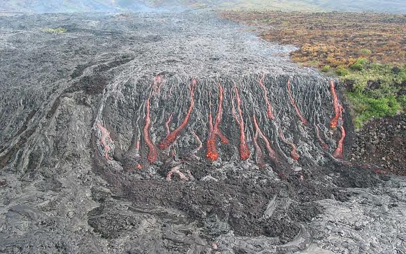
Then, in an incredible moment of good timing, the May 12th Mother's Day Flow began, and a huge river of lava began to make its way down the south flank of Kilauea. In a matter of weeks it was approaching the final pali (gigantic fault scarp/cliff) before reaching the coastal plain. On the day my flight landed in Hawai'i, the U.S. Geological Survey posted the picture you can see below (in case you have trouble with the perspective, the cliff in the photo is several hundred feet high. I was beside myself with anticipation. The lava was only a mile away from the end of the highway!
Source: U.S. Geological Survey
The timing was unique for several reasons. Because the flow was advancing towards the sea and making a new path, it had not yet formed a system of lava tubes which often hide the flow from sight. And as unintuitive as it sounds, the lava was not as hazardous as one might think. The advancing flow was so slow that the National Park Service was comfortable with park visitors walking right up to the edge of the lava.
Still, one has to be careful. One never knows when a fault might suddenly appear on a park highway (note the sign above). And strangely, in the way that all signs have a story, this was a place where a lava flow once burst out right onto the highway, in front of a very surprised vulcanologist!

I was in for a crushing disappointment, though. The advancing lava flow had started the biggest forest fire in Hawaii's history. The road providing access to the lava flow was closed for firefighting operations. I was devastated to say the least. Here I was, on the island for the first time in my life, the lava was easily accessible, and I wasn't going to get to see it...
I didn't know about Hawaiian attitudes towards fighting forest fires, though. Here in California fires are a serious business with an "all hands on deck" approach that has firefighters working night and day until the fire is out. Since this fire was not threatening homes or structures, the firefighting teams knocked off at five o'clock and went home for a beer or something. They opened the road! We joined the long traffic jam in a headlong rush down Chain of Craters Road to the beginning of the "trail" to the lava flow. I was wondering what kind of parking lot they had down there on the old lava flows. I soon found out. There wasn't one.
What happened instead is that one drove to the end of the road, did a U-turn, and then drove back up the road until a space appeared to park in. As we drove back up the road, my hike went from one mile, to two, to three. At least those extra miles weren't on rugged lava flows. I got out and quickly started down the road, filled with a sense of anticipation that I suspect only a fellow geologist can understand.
The "trail" was a set of yellow markers glued to the surface of the lava flow. It was something of a relief that the flows were of the smooth pahoehoe lava instead of the very rugged a'a type. I made good time running (yes, running; don't tell my wife about this) towards the lava flows. I was quickly becoming aware of the reason Hawaiian lava flows are best seen in dusk or at night. The incandescent rock is easily obscured in bright sunlight. At night, it turns into a light show.
I soon realized that I had active lava flows on three sides of me, and small fires were burning where the lava was engulfing shrubs. And then I was there at the leading active edge of the flow. It was one of the most unusual moments of my life. There just isn't anything that quite prepares you for standing inches away from molten basalt. It wasn't scary so much as it was hypnotic. I couldn't help staring at it in wonderment. This might be hard for some of you to believe, but for a few moments I forgot I was holding a camera and a video recorder. That didn't last long, because in mere minutes I was snapping away.
This was one of my first journeys with a digital camera, so I had a bit of trouble getting sharp pictures in the dim light from sheer ignorance of the capabilities of my camera. I got a few half decent shots of one of the most awesome events I had ever witnessed. Oh, but how I wish I had been carrying the camera I have today. I guess I'll just have to wait for the next big eruption!
When I was younger, I had a preoccupation with the idea of being the only human ever to stand in a particular place. I knew that most inhabited parts of the world had been trod by generation after generation of people, so I wondered how many times in my life I had actually put my feet on a spot that no other person had ever stepped. After my adventure in June of 2002, I know that I was the only person in all of human existence who ever stepped on a small plot of rock at the leading edge of an active lava flow. The rock had only existed for a few minutes when I stepped onto it while preparing for a picture. It was engulfed a few short moments later by the advancing basalt.

The lava began pouring into the sea just a few weeks later, in July of 2002. Soon most of the flow was hidden in lava tubes, visible only through a few skylights or breakouts, or along the coast where the lava met the waters of the Pacific Ocean.

Two Serene Hours in a Very Noisy Place: The North Valley Trail in Yosemite Valley

$
0
0
Yosemite Valley is an awe-inducing place, a place that was the inspiration for my current series on "What are the Most Incredible Places You've ever Stood"? I've been there many times and I never get tired of it. It is a destination for three of my field trips every year. It is an easy thing to drag a bunch of students up there (you make it required and stuff them on a bus), but how does one get past the sheer elegance of the scenery and explain to students the grandeur of the geological story of Yosemite as well? Part of it is letting them find out for themselves.

It's a bit of a trick to take 40 students to Yosemite on a busy Saturday in May. Buses are allowed to park in only two or three spots in the valley, and an extended discussion of geology is not possible in a place like the Wawona Tunnel View (above and below). It's simply too crowded with noisy buses and motorcycles and hundreds of tourists enjoying a first view of the valley, and it's really not fair to have a bus parked there hogging a premium spot. So we park the bus at Yosemite Lodge, and I set them free to wander through the park...to an extent. We make appointments. They find their way through the valley floor on the free trams, and we meet each other at a few of the most important localities (principally the Happy Isles rockfall site and a vantage point where we can talk about Half Dome and Yosemite Falls). It works well most of the time because they get a sense of exploration to go with the "learning".
I like the schedule for a different reason. The students have about two hours to find the visitor center and make a series of observations while making their way through the tram system to the other end of the valley. That's two hours that I can use to make some observations of my own, along with a bit of exploration. The trams are great, but nothing can compare with walking the length of Yosemite Valley on one of the less busy valley trails. Two hours of brisk walking for me equates to about six miles. I headed up the trail to Lower Yosemite Falls, trying to make my way through hordes of tourists (and a fair number of my students headed the same direction). It was crowded and noisy, but only a few hundred yards further I had the trail largely to myself.
 The North Valley Trail follows the base of the cliffs above the roads and valley developments. It is surprisingly quiet; I couldn't hear the traffic far below, only the breeze through the conifers and pleasant song of a bird I couldn't see or identify.
I soon passed a superb example of a talus slope at the base of Yosemite Point. In many places the cliffs of Yosemite are bold and vertical, but in other places there are recessed coves with extensive slopes of fallen rocks. The difference lies in the pattern of jointing in the rock. Granitic rocks form deep in the crust miles below the surface under great pressure. As they are exposed by erosion, the rocks expand and fracture. The composition of the rock seems to determine the spacing of the joints, and when they are far apart, bold cliffs occur. When they are closely spaced, rock falls are common and talus slopes are the result.
The trail climbs several hundred feet above the valley floor, offering views in both directions. Across the valley stands Sentinel Rock, one of the most imposing cliffs in Yosemite (although it sometimes gets lost in the scenery, being located across the valley from Yosemite Falls). On the other side are the cliffs of the Three Brothers. The cliffs that make the three brothers are more easily seen from the other side, but from my vantage point I could see the scar of the 1987 Three Brothers rockslide, which dumped something like 600,000 cubic yards of debris onto the valley floor. Luckily no one was hurt, since the park service had some warning that a big slide was imminent and closed the road at the base of the cliff. It was the largest mass wasting event in the recorded history of the valley.
John Muir and other earlier visitors remarked on the open park-like aspect of the woodlands on the valley floor. Fire suppression since the establishment of the park in 1890 has allowed the growth of a thick forest across most of the valley, but below the Royal Arches and Washington Column there are some beautiful old oaks that recall the original state of the valley at the time it was discovered by Europeans (the Miwoks and other first nation people have known of the valley for thousands of years).
Half Dome soon became visible as I worked my way towards Mirror Lake.
 The Dogwoods were still blooming along the side of the trail.
After three or four miles of walking I arrived at Mirror Lake. The "lake" is more of a wide spot in Tenaya Creek that developed as a result of a gigantic landslide in prehistoric time. The creek formed a series of ponds behind the rockslide that in springtime reflect the surrounding cliffs, especially Mt. Watkins and Half Dome. By summer Tenaya Creek often runs dry (especially this year with the drought conditions). On Saturday it was beautiful, but also crowded. I set off towards Happy Isles and soon left the crowds behind.
Half Dome from the vantage point of Mirror Lake is the very definition of "looming". It is nearly 4,000 feet of steep cliffs. Another major mass wasting event took place near here in 2009, the Ahwiyah Point rockfall. It involved something like 115,000 tons of granitic rock. Luckily it happened early in the morning and no one was hurt.
The small details are easy to miss in a crush of people. I enjoyed some more Dogwood flowers...
...and the hard work of huge bumblebee in the Lupine blooms.
After I met with the students at Happy Isles, we started making our way back to Yosemite Lodge. I took one look at the packed tram, and decided it would be nicer to walk back. The direct route was two or three miles, and I had a fair chance of beating the tram (the dozen or so stops and the heavy traffic made for a slow motorized journey). Along the way I was thrilled to see a White-headed Woodpecker for the first time.
Our final stop was in a meadow at the base of Yosemite Falls. It provided an outstanding view of Half Dome where we could discuss the origin of the iconic feature. Soon after we were back on the bus and headed home. It was a spectacular day!

Where are the Ten Most Incredible Places You've Ever Stood? My Number 5: Walking in the Footsteps of James Hutton

$
0
0
This entry into my series on the "Ten Most Incredible Places I've Ever Stood" is sort of a two-for-one deal. It was my journey into a different kind of geological past, the history of the science rather than the history of the world, although that was part of the story too. This was a visit to the birthplace of geology as a science, at two locations in Scotland.
"What clearer evidence could we have had of the different formation of these rocks, and of the long interval which separated their formation, had we actually seen them emerging from the bosom the deep? We felt ourselves necessarily carried back to the time when the schistus on which we stood was yet at the bottom of the sea, and when the sandstone before us was only beginning to be deposited in the shape of sand or mud, from the waters of a superincumbent ocean. An epocha still more remote presented itself, when even the most ancient of these rocks instead of standing upright in vertical beds, lay in horizontal planes at the bottom of the sea, and was not yet disturbed by that immeasurable force which has burst asunder the solid pavement of the globe. Revolutions still more remote appeared in the distance of this extraordinary perspective. The mind seemed to grow giddy by looking so far into the abyss of time...."

These are the words written by John Playfair as he described an extraordinary boat journey he made with James Hutton in 1788 to Siccar Point, a spot where Hutton found confirmation of his model of the Earth's development. At the point, Silurian graywacke sandstone layers (425 million years old) stand nearly vertical, and are overlain by bright orange and brown layers of the Devonian Old Red Sandstone (345 million years). Such features are called unconformities. During the interval of time before the deposition of the Old Red Sandstone, the sea floor had been compressed and thrust upwards into a mountain range that was subsequently eroded completely away. Such events required the passage of vast amounts of time, something quite incompatible with the mere 6,000 years of Earth's existence assumed by medieval religious scholars. Hutton's explorations of Scotland ignited the revolution that led to the development of the science of geology.

In 2001 I had the chance to visit some of Hutton's most famous rock exposures. We had put together our very first international field studies journey to England and Scotland, and being unfamiliar with the territory, we had contracted with a tour company to take care of the logistics. We got a canned tour of the famous tourist localities like Stonehenge, Big Ben, and Edinburgh Castle, but we made special arrangements with the tour company (for a price) to deviate from their usual itinerary (we missed the golf courses of St. Andrews) so we could instead head into the southern uplands of Scotland to Siccar Point. We committed to the trip 1 1/2 years in advance, having no idea that hoof-and-mouth disease was about to be detected in the British Isles, including the farms around Siccar Point. To my almost unspeakable frustration, access was impossible. Not wanting to just give up, I pulled out the topo maps and we made our way to a campground on the coast about a mile north of Siccar Point. I read the passage from John Playfair to the students, and than I ran as far as I could along the beach cliffs to where I could see the point, but not the relationships (although we could pick up the associated rocks along the coast).
The idea of unconformities and the concept of geological time would have been enough to secure Hutton's reputation as a geological pioneer, but he made another profound observation in the middle of the city of Edinburgh. That was the second spot I was seeking on this geological pilgrimage.

For years I've been showing a video to my students on the development of the theory of plate tectonics. It was done in the early 1990s but has held up well aside from the ancient computers in some of the scenes. It begins in Edinburgh with a look at the Salisbury Crags and Arthur's Seat, where James Hutton discovered an ancient volcano that once sat on the sea floor. Other observers in these early days of geology thought that basalt accumulated on the sea floor by precipitating out of the water, much like salt deposits in a drying bay. Hutton found a contact zone in a small quarry at the base of the Salisbury Crags where the intruding basaltic rock had pried up the previously existing sedimentary layers forming a vast sill. In other parts of Scotland he found intrusions of granitic rock that had done the same thing. In short, he had discovered intrusive (or plutonic) igneous rocks, and opened our eyes to an entirely different way of considering our planet, an active planet with an internal heat source, and cyclical processes that had been operating for millions, not thousands, of years.
I didn't have much of a clue about how to find the quarry, but sunset came late in our northern latitude, so after dinner I set out from our hotel and walked to the crags. It didn't actually take very long before I found a concrete monument and the very exposure that had been illustrated in Hutton's early books. It was a marvelous moment in my geological life (and a great sense of relief because I was going to be showing it to my students the next morning and had to pretend I knew where it was all along).
The big adventure of the next day would be the climb up to the summit of Arthur's Seat, the eroded and glacially scoured volcano that had once been in an ocean. The peak is surrounded by the city of Edinburgh, and was originally preserved as a deer hunting park for the king, but more recently because of a number of rare plant and animal species, as well as being a bit of greenery in an urban setting.
The peak is an archaeological treasure with the remains of ancient fort at the summit, and the ruins of a chapel, St. Anthoney's, built in 1425 on the flanks. It was such a strange sight for the middle of a city.
Although it was a bit hazy, the whole city was visible from our 822 foot summit. We could sit on our "throne" and consider the volcanic eruptions that built up the volcano, the continental collision that deformed and tilted the rocks, and the glaciers that scoured the flanks during the ice ages of the last two million years.
Do these pictures look a little fuzzy, a bit low of resolution? There's a story there. I had heard of digital cameras, but they were expensive and I couldn't fit them in my budget (my, how times have changed...). Because the Scotland trip was a major event for our department, I convinced the administration to spring for a modest camera (an entire 3 megapixels!), and it arrived in Shipping and Receiving late in the afternoon before our departure the next morning. When I got on the plane, I had taken and downloaded all of three images. I barely knew how to use the camera, and didn't really trust the technology, so I ended up mostly taking lower resolution pictures. I would never make that mistake again, but such is the learning curve. At least I didn't accidentally delete them all like I've done on a few other occasions. If you would like to see some very excellent and more recent pictures of Arthur's Seat, check out this recent post at Magma Cum Laude: http://blogs.agu.org/magmacumlaude/2014/04/06/edinburgh-arthurs-seat-and-salisbury-crags/
Not many people in Edinburgh know of James Hutton, and his role in the development of the science of geology. Mostly I got blank stares when I asked directions to the monument. James Hutton is buried in Edinburgh and we paid a visit to the cemetery, but they had to pull out a catalog to find out where he lies buried. The section of the cemetery where he is interred was locked and chained, apparently because of continuing abuse by leaders of the popular ghost walks of Edinburgh (yeah, I took one too, but aside from atmospheric fog in the streets I was unimpressed).
Hutton's resting place is on the left side of this yard.
How much does the average person know about Scotland and England? That there is a queen, and the men wear kilts. We of course realized that we weren't going to be seeing any queens, and it was silly to think that all the men in Edinburgh would be going around in kilts. Except that both of those things happened!

As we made our way down the road towards Arthur's Seat, we noticed that nearly every man on the street was wearing a formal kilt, and we wondered why. As we approached Holyrood Palace, we realized that everyone was gathering for a "garden party" hosted by Queen Elizabeth. There were just a few people in attendance, about 8,000 of them. From our vantage point on the flank of Arthur's Seat, we could pick her out, wearing a blue outfit in a receiving line next to the side of the building just slightly left of center in the picture below. Yes, it was a crazy, unique day.
Just to accent the weirdness, we passed the street sign below. It wasn't actually a prophecy, but instead was an alleyway (a 'close') on the edge of the old city, which was the edge of the world to the medieval inhabitants.

Viewing all 1182 articles
Browse latest View live


Latest Images