Quantcast
Channel: Geotripper
Viewing all 1206 articles
Browse latest View live

A Stroll Through the Gateway to the Narrows of the Virgin River

$
0
0
I bet no one has ever thought to take pictures of this place before! Or not. The Gateway to the Narrows trail is only the most popular trail in one of the most visited national parks in the system. I often try to describe places off the beaten path, but sometimes it's fun to catch these popular spots and be reminded why they are so famous in the first place.

Zion National Park is the ultimate exposure of the dramatic Navajo Sandstone, which formed in early Jurassic time as a widespread "sea" of sand dunes extending from Wyoming to Arizona and Nevada. The formation is more than 2,000 feet thick at Zion, where it forms vertical red and white cliffs.

The cliffs have been exposed by the rapid incision of the region by the forks of the Virgin River. Where the river has reached the underlying Kayenta Formation, mass wasting and erosion has caused rapid cliff retreat, forming a wider valley with a flat floor that allows for the development of tourist facilities (the campgrounds and visitor centers and such). Things change at the upper end of the valley where the river is flowing exclusively in the Navajo Sandstone. The canyon is 2,000 feet deep, but in places is only a few feet wide. The Narrows of the Virgin River is a stunningly beautiful place.

At road's end at the Temple of Sinewava, an easy 1 mile paved trail provides access to the narrows. That's where I was the other day.
It is one of the more crowded spots in the park, but the mess is mitigated somewhat by the wise decision of the park service a decade or so ago to ban cars from the upper canyon. Today, the only engine noise comes from a tram every ten minutes or so. The hikers jump out, disperse, and it is quiet again.
When the lower canyon is stewing in the desert heat, the Gateway is cool and shady (no wonder it is popular). Water seems to be everywhere, in the river itself, and dripping out of the canyon walls. The Navajo Sandstone is quite permeable, but the underlying Kayenta Formation is not. Springs are often found at the contact between the two, such as at the "swamp" (our friends on the trip from the southeastern states probably snickered a bit about the name; at least we didn't have to worry about crocodiles...).
The lush greenery attracts plenty of animals, including a national park deer (i.e., they graze right next to the trail and pose for pictures).
 The springs emerging from joints in the rock produce beautiful hanging gardens with flowers of all kinds.
 The columbines are my perennial favorites...
 As the sun climbs higher in the sky, the walls of the canyon are reflected off the Virgin River.
For all the crowds, it is a beautiful and serene place.The paved trail ends at the entrance to the Narrows of the Virgin River. One can don some water shoes and explore upstream for miles. Or take a road to the isolated north end of the park and backpack downstream through the narrows. Or one can just sit somewhere and listen to the river and the birds.

More on Zion in the next post!

What Is Your Favorite Volcanic National Park?

$
0
0
So many great choices! Would it be Rainier? Crater Lake? Lassen? Hawaiian Volcanoes? Haleakela? Yellowstone? Zion?

Wait a minute...Zion? Since when does Zion National Park have volcanoes? Since about 125,000 to 1.4 million years ago, actually. The western edge of Zion includes the Hurricane fault zone and a series of associated basalt flows and cinder cones. Firepit Knoll (above) and Spendlove Knoll (below) are two nearly symmetrical cones dating to around 220,000-310,000 years ago.

The park also has an outstanding example of an inverted stream. A flow filled North Creek and erosion removed the surrounding softer rock, leaving the former stream bottom as a prominent ridge.

It's a bit tricky to see, but cliffs drop off both sides of the road, which was built on the surface of the basalt flow. From higher up, the ridge is more obvious (below). The flow emanated from the Firepit/Spendlove Cones.

Where are these features, and how do they get missed by 95% of the park visitors? They can be viewed by following Kolob Terrace Road to Lava Point. The park brochure mentions the road, but I guess there are so many exciting things to see down in the canyon that folks don't set aside enough time to explore this road into the high country. It's both a shame and a blessing.

A blessing because I don't like crowds, but a shame because people are missing out on a very scenic and geologically interesting road. The road climbs 4,000 feet in 21 miles from the village of Virgin to Lava Point, one of the highest points in the national park. On the day we were there last week, the temperature dropped from 104 degrees in the valley to 78 degrees at the lookout. Aspen trees lined the last mile of the drive (most of the road is paved, except for this last bit, but the road is smooth).

The road begins in the Triassic Moenkopi Formation, and quickly ascends the lava flows to exposures of the Jurassic-aged Navajo Sandstone. This is the same unit that forms the spectacular cliffs of Zion Canyon. Without the vertical canyon walls, the Navajo weathers into a bewildering variety of beehives, castles, spires, domes, and whatever else your imagination conjures up.

The road crosses the park boundary several times, and passes through beautiful park-like meadows.

At road's end, we discover why the spot is called Lava Point. Columnar basalts form a cap on the edge of the plateau. At nearly 8,000 feet, the area is covered in a fir and aspen forest.

In a meadow near Blue Springs Reservoir, I caught a horse hanging out with a little friend catching flies on his back.
The cacti were in bloom here and there.
And then there is the view! From this vantage point, we can look into the deep canyons of Zion, and beyond to the Kaibab Plateau and the Grand Staircase. The view also extends to the high plateau country to the north.

There is a small campground set a few hundred yards from the edge of the plateau. There were a few people camping there, and all of six other cars at the viewpoint. It was cool, shady, quiet, and beautiful; a distinct contrast to the normal tourist haunts in Zion Canyon.
Give it a try next time you are in the region. And don't forget the Kolob Fingers, the other outlying, lesser-known part of Zion National Park.

The Three Stages of Hoodooism....

$
0
0
Some folks make a big miscalculation if they visit Bryce Canyon National Park. They seem to believe that if you've seen one hoodoo, you've seen them all. They may be in a hurry, and thus hit the one famous overlook, like Sunset View, or Inspiration Point, and head out to Ruby's for lunch, and then on to Zion. They miss out. There is a twenty mile long park road that has a dozen or more stops, and once you know what to expect, you can enjoy the sometimes subtle and sometimes obvious differences.
I mean, this is hardly memorable at all, right?

Here's what I am getting at...there are unique sections of the park that reveal differences in the degree of erosion that has eaten away at the edge of the plateau. The Silent City, in the most visited and most photographed part of the park, is a vast expanse of countless hoodoos, and there is no place quite like it in the world. But the formation of which it is made, the Claron Formation, is present over thousands of square miles in southern Utah. Why aren't there dozens of valleys out there just like this one?

It has to do with the degree to which erosion has reached the underlying Cretaceous layers. In the northern stretch of the park, around Fairyland View, headward erosion of the Paria River has only begun to attack the Claron, and essentially only the "tops" of the future hoodoos are sticking out.
Fairyland is colorful and beautiful, but it is mostly lacking in the tall hoodoos that characterize the Silent City in the central part of the park. The incision caused by the occasional flash floods just hasn't cut very far into the freshwater limestones of the Claron Formation. As time goes on, the gullies will become deeper and deeper, and the hoodoos will reach their zenith in height and relief.
In the diagram above, note how the deepest slot canyons have almost reached the underlying Cretaceous sediments. The sediments include weakly consolidated sandstone and siltstone that is easily eroded. Once the contact has been reached, the hoodoos will rapidly disappear. Until then, the scenery is spectacular! The Sunrise, Sunset, Bryce, and Inspiration viewpoints in the central part of Bryce Canyon National Park are truly incredible places to learn about hoodoos. The hikes into the depths of the slot canyons, especially Wall Street, are memorable.
The southernmost part of the park, at Yovimpa and Rainbow Points, represents the last stage in the disappearance of the hoodoos. The Claron Formation only makes up part of the cliff face, and only a few hoodoos are evident.
Most of the hoodoos may be gone from the valleys below, but Rainbow and Yovimpa Points are at the highest point in the park, and the view from each point covers thousands of square miles of plateau country, including the heart of Grand Staircase-Escalante National Monument, and far off in the distance, the Kaibab Plateau and the Grand Canyon. On this recent trip, we could make out the snowy peaks of the Wasatch Front to the north, many miles away.

Bryce Canyon deserves a leisurely exploration. It's not a place to rush through...after all, if you disrespect the petrified beings of the Silent City, you might suffer a "hoodoo curse"!

A Tale of Two Arches, But Not in Arches

$
0
0
Travelers in the southwest might get the idea that arches can only be seen in Arches National Park in Utah. It's true that Arches National Park has the largest concentration of arches in the world, and the world's longest arch is found there, but arches have formed all over the Colorado Plateau. I saw two notable examples last week, and they can be seen in today's post.
Grand Staircase-Escalante National Monument has a rather spectacular version of one in Grosvenor Arch, about eight miles east of Kodachrome Basin State Park. The cliff is composed of Henrieville Sandstone (Jurassic in age), with a capstone of Dakota Sandstone from the Cretaceous Period.
It used to be called Butler Arch, but an expedition from the National Geographic came through the area in 1949, and they pulled strings to rename it after their boss. The biggest of the two arches is about 152 feet high, and 100 feet wide.

We heard an ungodly screeching all around us while at the arch, and it didn't take long to find the noisemaker: a bunch of cicadas. They look like horrifying beasts of Hades, but are essentially harmless.
Driving west from Grosvenor, we passed a nice viewpoint of Wiggler Wash, where the creek cuts through a fold, exposing the Entrada Sandstone and Henrieville Sandstone. The pink cliffs of the Aquarius Plateau can be seen in the far distance.
This was a tale of two arches, but I actually didn't mean the double arch of Grosvenor. The next morning we were at Bryce Canyon National Park, another place where arches form readily. One of them can be seen from a pullout in the southern part of the park. It's called Natural Bridge, but as the signs and irritated geologists will tell you, bridges span creeks, while arches form by other means. But it's pretty neat in any case.

My posting will be very spotty over the next two weeks. I had so much fun on my one week exploration of Grand Canyon, Bryce and Zion that I am headed back out there again, this time with two dozen students. We're making a huge loop through the plateau country, with no wi-fi motels, and rare access of any kind. I might actually have to breath the air, hike around for entertainment, and gaze at stars at night. I'll try to maintain a positive attitude!

On The Road to the Back of Beyond...

$
0
0
 There are places I remember
All my life, though some have changed
Some forever not for better
Some have gone and some remain 

These Lennon/McCartney lyrics hit me every time I set out on the road to the Colorado Plateau, which is both a geologic classroom, and a sort of spiritual center of my Universe. The deceptively barren desert is full of life, and at the same time full of ghosts. Some parts are so familiar to me that I can feel the texture of the sandstone in my imagination, and other places, many places, are yet to be discovered.

Change has happened out on the plateau over the years. Former gravel roads are paved over, cities have grown, others have become smaller. Geological changes are happening too, the ever-present erosion and occasional rock falls, and other more subtle changes brought about by a decade of drought. Is the change permanent? I suspect it is.
The rocks and soil that form the framework on which all life thrives is passive. It has been witness to millions of years of change, and an ever-changing parade of life forms. The trail above was cut out of a separation plane on a sand dune that was trod on by reptiles and insects 200 million years ago. The sand grains were eroded from a mountain mass hundreds of millions of years older. We are brief visitors on this land before our atoms get scattered and recycled.

For the next two weeks I get to play the role of mentor to a group of students who will be seeing this landscape for the first time in their lives. I don't know who will learn more, them or me!

I'll be missing in action for a few weeks, but I will sign in when I can.  Gaelyn, hopefully we'll see you on the 17th or 18th! 

The First Stage of our Journey: Basic Principles

$
0
0

We are into our third day on our journey through the Colorado Plateau, and yesterday we actually reached the plateau. We needed to get out of the Central Valley, cross the Sierra Nevada, and then make what once was a terrifying traverse of the dreaded Mojave Desert. My family recounts the difficulty of driving the Mojave in the immediate aftermath of the Great Depression, with long steep grades on Route 66 that were driven primarily at night for fear of overheating the radiator system of the old Ford. It was of course worse for colonists in covered wagons. To the Paiute people, it was simply home.

For us it was a pleasant drive (for once), as we had cooler weather than normal, and no serious accidents on the highway causing delays. We had the time to explore one of my favorite teaching sites in the region, Rainbow Basin National Conservation Area.

The basin exposes the colorful beds of the Miocene Barstow Formation, and the rocks have a rich record of fossil discoveries, including early species of elephants, horses, camels, bear-dog ancestors, cat ancestors, and even multitudes of insects and arachnids. But best of all, it is a place to learn the basic principles of geology.

We talked about Steno's principles of stratigraphy and cross-cutting relationships, and the students set about telling the sequential story of the outcrop seen above. Can you do it? Can you lay out a sequence of events that tells the story of how this rock came to be the way it is? I'm glad to say the students did pretty well, especially since this exposure is our SLO exercise (student learning outcome).
I'll post again when I get a chance!

Yeah, I'm Still Here (and there, and everywhere): SUPER MOON!

$
0
0
Hey world! I'm still here...and there...and it feels like everywhere, and we are having a great time exploring the geology of the Colorado Plateau. This has been one of our cooler trips ever, with spring-like temperatures (and windstorms), so we are enjoying it as much as possible. Since the last post, we've been to Grand Canyon, Cedar Mesa, Mesa Verde, Arches, Canyonlands, Capitol Reef and lots of other wonders. We are actually just two more days from being home.

I know the SUPER MOON was overblown, as usual, but a full moon rising at Arches National Park is nothing to sneer at. It was gorgeous, and if you want to see it supermoon style, you just up the zoom on the camera, and voila!

A morning or two later, we could watch the moon setting among the Entrada Sandstone cliffs...
Lots of pictures, lots of adventures in geology to talk about. We'll see you in a few days!

The Abandoned Lands: A Compendium of Geology Explorations on the Colorado Plateau

$
0
0

During the summer of 2012, I explored the margins of the Colorado Plateau with a group of geology and anthropology students. I was struck by the way that the land tended to defeat the best efforts of those who wanted to colonize and "tame" the landscape. From this grew a blog series that I titled "The Abandoned Lands". As I prepared to explore these lands again from a different perspective, I realized I had never put together a compendium of the posts that I wrote last year. So with your patience, I now do so. Look for them "beneath the fold"...


The Abandoned Lands: A Journey Through the Colorado Plateau
The introductory post that explained the name and rationale...

Beginnings
We set out on the road, and see a horrific accident. We start right away seeing the contrast between a bounteous land, and one that challenges life.

A Real Hole in the Wall
We discover evidence of an ancient catastrophe, the eruption of the Peach Springs Tuff, at Hole in the Wall in the Mojave National Preserve.
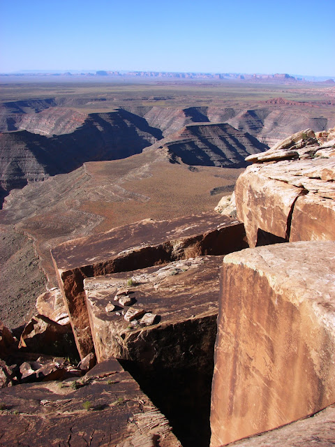
The Grandest Canyon
We drive (drive!) to the bottom of the Grand Canyon, and have a look at the river that is responsible for much of the scenery found on the Colorado Plateau, as well as seeing the Great Unconformity.

The Seven Stages of Grand Canyon Awareness
An understanding of the Grand Canyon can be achieved on many levels. Here is a seven-part hierarchy of awareness.

And not a single sentient being ever laid eyes on the mountains
An exploration of the Proterozoic history of the Grand Canyon as revealed in Peach Springs Canyon, a story so ancient that no beings of any sort witnessed it. Oh, and a herd of bighorn sheep!

Where the Rivers Changed Direction
Peach Springs Canyon reveals a startling fact: there was a "Grand Canyon" here in the age of dinosaurs, and the river flowed in the opposite direction that it does today.

Three Grand Canyons in One
A discussion of the Grand Canyon Supergroup of the late Proterozoic. The rocks are three times as thick as the Paleozoic rocks that make up the walls of Grand Canyon.

The Little Colorado River is little, but the canyon it's in isn't
Even the tributaries to the Colorado River are spectacular. A vertical walled canyon on the Navajo Reservation...

Wupatki and Sunset Crater
We begin our exploration of the human habitation of the Colorado Plateau at Wupatki National Monument. An Ancestral Puebloan village was destroyed by the eruption of Sunset Crater a thousand years ago.

The River Red, a little red goes a long way
The Paria River and the Colorado: Red and green come together.

Walnut Canyon: Would you have been one of them?
A national and cultural heritage was pillaged and vandalized long before Walnut Canyon came under federal protection.

Not so much abandoned as obliterated
A look at Meteor Crater, a catastrophe out of nowhere.

There is at least one forest in the Southwest that won't burn this year
A look at the Triassic Chinle Formation and the petrified forest it reveals

Twitter and Facebook, circa 1605: Exploring El Morro National Monument
The only watering hole for many miles: El Morro was a gathering place, with messages spanning more than a thousand years scratched onto the rocks.

There are some who won't give up
Acoma Pueblo has been continually occupied for nearly a thousand years. This land doesn't defeat everyone.

I've looked at erosion from both sides now
Taking a look at a slot canyon from above and from below. Where is it?

Kasha Katuwe Tent Rocks: Erosion in Action
Exploring the strange hoodoos of Kasha Katuwe National Monument

The Rise and Fall of Empires...
A look at Pecos National Monument, a once powerful fortress brought to ruin, and the first Civil War battlefield I've ever visited.
 
Surviving in the Great Rift
The Rio Grande Rift is a gigantic gash that threatened to split the American continent in half. But then it stopped. Today it forms an eastern boundary to the Colorado Plateau. We look at the sometimes tragic history of Taos Pueblo.

Migrations, Calderas, and the middle of the story at Bandelier
Bandelier National Monument is one of the strangest archaeological sites on or near the Colorado Plateau. The dwellings were built right into the cliffs of rhyolite tuff.

Calderas and Inside-Out Caverns
We take a look at the Jemez Caldera, the site of a huge eruption not so long ago. And a cavern forming in broad daylight!

The Cosmos and Mystery at Chaco
We pay a visit to a former center of the Universe for the Ancestral Puebloans, on the Summer Solstice. Chaco Canyon is a mystical kind of place...

The Rise and Fall of Empires, Part 2
An exploration of the incredible city-states of Chaco Canyon, and how they came to be abandoned.

The Rise and Fall of Empires, Part 3
More discussion of the civilization of Chaco that came to an end.

700 Years in the Fertile Crescent
We start our exploration of Mesa Verde National Park, one of the greatest architectural wonders of the world. Why did the Ancestral Puebloans choose (and abandon) this place?

In death and the end of all things, there is beauty?
The beautiful cliff dwellings of Mesa Verde were occupied for only a few decades. The Ancestral Puebloans lived on the mesa tops for more than six hundred years before they retreated to the alcoves.

What will be the evidence be of your passage?
Musings at the Anasazi Heritage Center in Dolores, Colorado. A great display of artifacts, unfortunately retrieved before being inundated by a reservoir.

The fusion of geology and architecture, part 1
We look at some of the most unique dwellings to be found anywhere at Hovenweep National Monument.

The fusion of geology and architecture, part 2
The dwellings of Mule Canyon in Utah. A hiking adventure...

A bit of the Wild West remains at Bodie
We briefly abandon our Colorado Plateau trip for a look at Bodie, a well-preserved gold mining town in eastern California.

The Joys and Perils of Serendipity on the Lisbon Valley Anticline
The story of Charlie Steen and the uranium boom on the Colorado Plateau.
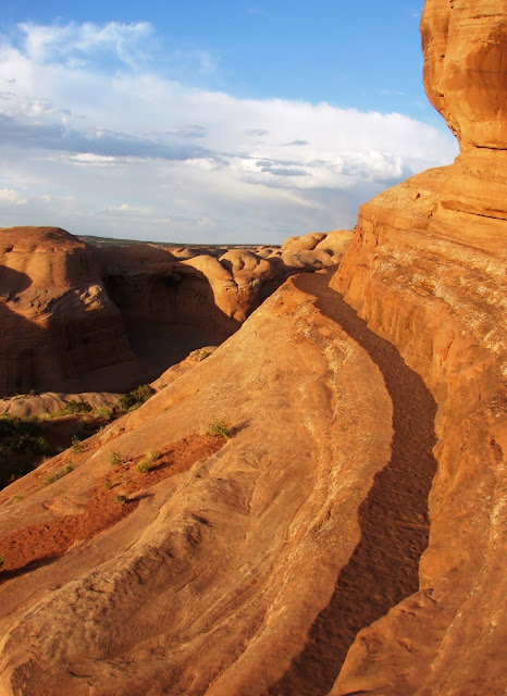
One extraordinary day in the canyonlands, part 1
A beautiful sunrise on the fins and spans at Arches National Park on a long and interesting day in the Canyonlands Section of the Colorado Plateau
 
One extraordinary day in the canyonlands, part 2
A hike out to the world's largest arch, and a look at another smaller, but beautiful arch in Arches National Park.

One extraordinary day in the canyonlands, part 3
The Windows Section of Arches National Park, and the Indiana Jones arch!

One extraordinary day in the canyonlands, part 4
We move on to Canyonlands National Park for a look at an extraordinary landscape inhabited by no one anymore. No native Americans, no miners, no ranchers, they all left it behind.

A day in the canyonlands, a fiery end
One of the more beautiful sunsets I've ever seen, from the Sand Dune Arch Trail in Devils Garden at Arches National Park.
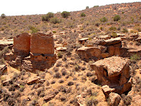
We had to save a village in order to destroy it
The Fremont were an enigmatic people who occupied the regions north of Anasazi territory. One of their largest villages lay in the path of a new interstate freeway, and thus it had to be destroyed. Pieces were preserved at Fremont State Park.

A Hell of a Place to Lose a Cow
Bryce Canyon is one of our premier national parks, and for a good reason. A great walk through Wall Street Canyon.

Wrapping up a tour of the Colorado Plateau
Trials and tribulations on our final few days in the Abandoned Lands...a tour Zion National Park, a wonderful cavern at Great Basin National Park, and fires burning across the region.

Out of America's Never-Never: Two Weeks on the Colorado Plateau

$
0
0
Sunrise in Goblin Valley State Park, Utah

Say Never-Never Land and most people immediately think of Peter Pan and Captain Hook, but the term has an older meaning of which J.M. Barrie was probably unaware. The Never Never is a remote and largely inaccessible part of the Northern Territory and Queensland of Australia's Outback. To some, it is a place that one would "never, never" want to go (despite this neat-sounding trip). To some of those who live there, it is a place one would never, never want to leave.

I see many parallels between Australia's Outback and the American Southwest, especially the Colorado Plateau. Most of the local populations live on the margins of the region, and until recent decades anyway, many parts remained unexplored by people of European descent. To others it has been home for thousands of years. The lands are ancient, each revealing a fascinating geological story.

So welcome to America's Never Never. I've just returned from my latest journey through the wonderful landscapes of the Colorado Plateau, and although we mostly followed modern highways, we could sense the isolation and wildness that is still inherent to this country. I hope you will enjoy the journey over the next few weeks in pictures and stories.
Mesa Arch in Canyonlands National Park, Utah

Out in America's Never Never: Getting There

$
0
0
Photo by Mrs. Geotripper

A journey into the Never Never of America has to have a beginning in the green lands. From our base in the fertile Central Valley, we traveled through 200 miles of irrigated farmlands. They would be part of the desert were it not for a massive water project drawing water from northern California. We crossed the Sierra Nevada at Tehachapi Pass and continued into the Mojave, a desert that exists because of the rain shadow effect. Pacific storms are wrung dry by the imposing walls of the Coast Ranges, Sierra Nevada and Transverse Ranges.
Photo by Mrs. Geotripper

The western Mojave could hardly be mistaken for wilderness outback. Los Angeles has spilled over the mountains, with hundreds of thousands of people living in towns like Palmdale and Lancaster. Power lines and railroads crisscross the desert, as well as numerous paved highways.

We made a short stop at the massive open pit mine at Boron, one of the world's largest sources of borate minerals. The mine, operating since the 1920s, is now 500 feet deep, a mile long, and half a mile wide. A visitor center perched on the edge provides a marvelous view of the operation.
As we continued eastward, the trappings of civilization began to fall away. Barstow is a crossroads town of just over 20,000 people. At the north end of town, a road provided access to Fort Irwin (eerily accompanied by a lot of white crosses from traffic fatalities), but our route took us on a side road to Rainbow Basin.

19 to 13 million years ago, the Barstow region was not a desert. It was a savanna, with wandering streams and ephemeral lakes. The grasslands included groves of palm trees, and numerous grazing animals that were the ancestors to the elephants, antelope, horses, and camels that are familiar to us today. The grazers were preyed upon by a collection of primitive canines and felines, as well as amphicyon, a large carnivore that can visualized as an ancestor to the bears and dogs. The sediments that collected in the isolated basins accumulated to a depth of more than 3,000 feet, with a brightly colored assemblage of freshwater limestone, sandstone, siltstone, conglomerate, along with a series of volcanic ash layers that made it possible to date the formation.

The layers were later caught up in the deformation that began as the San Andreas and other faults warped and twisted the crust. In the center of Rainbow Basin, the Barstow Formation was deformed into a textbook example of a syncline, a downward pointing fold in the rocks. This is the syncline I wrote about a few weeks ago. I used the outcrop as an introduction to basic stratigraphic principles, and the students sketched the relationships, and outlined a sequence of events to account for the scene ahead of us. Here is the sketch as I would have done it...

The principle of superposition tells us that the oldest rocks will be found at the base of the sequence, so the Barstow Formation is the oldest rock visible. The principle of original horizontality tells us that most sediments are laid down in flat layers, so we can state that the Barstow Formation has since been twisted from its original position. The principle of lateral continuity shows us that the red and green layers of the Barstow have been eroded, because they end against an overlying layer instead of the edge of the original basin. The erosion surface is termed an unconformity. The principle of cross-cutting relationships tells us that the faulting took place after the deposition of the Barstow Formation, but before the erosion that produced the unconformity. And after all of this, erosion exposed the rocks for us to see on a warm Saturday in June at the start of our long journey.

We headed east from Barstow on Interstate 40, and all evidence of civilization disappeared, with the exception of the narrow strip of pavement we were following. The desert spread out for miles in every direction. As the sun disappeared beneath the horizon, we made the turn north to Hole in the Wall within the Mojave National Preserve, a national park for all intents and purposes except for the right of a few to shoot wild "game". When the vans were parked, the silence was striking. We had reached the land I'm calling Never Never.

For the first time in many months, I just stared at the sky. Early on, the sky was dominated by the quarter moon, but later, when the moon had set, the sky filled with stars. I did a time exposure over Woods Mountains...

It was a beautiful and peaceful night, the first for me in a long time. It was dreamtime.

Out in America's Never Never: The Mojave, a Vast Unknown Treasure

$
0
0
My students are reading this and saying "We didn't stop here". That's true. But I love the picture and any excuse to show it.

The first morning on the road into America's Never Never found us at Hole in the Wall in the middle of the Mojave National Preserve. The Mojave is a vast region in eastern California that is both well-known, and completely unknown to the residents and visitors to the state. It's "known" because millions of people travel Interstates 15 and 40 every year through the region on their way to Las Vegas or Phoenix. It's "unknown" because the vast majority of travelers never set foot outside their cars except for the bathrooms in Baker or Needles. The landscape between the two interstates is a vast terra incognita to them. It's no wasteland...it is an exceedingly fascinating region, geologically and biologically.
We did wake up to this sight, though. The Providence Mountains, west of Hole in the Wall.

We passed through the heart of the park, traveling from the Essex turnoff on Interstate 40 for 20 miles to the Hole in the Wall campground, and then through the Mid Hills and Mojave Road to Kelso-Cima Road and the Morning Star Mine Road to Interstate 15. Although our time was short, we saw some vast vistas of the third largest unit in the national park system outside of Alaska (I think only Yellowstone National Park and Death Valley National Park are larger; Grand Staircase-Escalante National Monument is also larger, but is administered by the Bureau of Land Management).

The park has a series of unique ranges, including the Providence, Granite, Clark, and New York Mountains, reacing elevations of just short of 8,000 feet. The great range of elevation allows a huge variety of plants to thrive. Of greatest interest (to me anyway) are the Joshua Trees and the White Firs.

Wait, Christmas trees in the desert? Yes! There are relict forests that cling to life at the tops of the highest peaks of the New York and Clark Mountains. During the ice ages when the climate was wetter, they thrived over a much larger area, but with the ending of the glacial advances and the drying, they retreated to the small groves that exist today. It's a part of the park I have not yet had the privilege to visit, and I can't find pictures on the Internet, so that may be part of a future trip.
Photo by Mrs. Geotripper

The Joshua Trees, on the other hand, are right there. The largest grove in existence, more than a million individual trees, can be seen on Cima Dome. We stopped to have a look. The Joshua Trees are members of the lily family and are widespread throughout the Mojave Desert. Joshua Tree National Park preserves many of the trees, but Mojave National Preserve may actually have more of them. Some of the trees on Cima Dome have trunks 3 feet across, and may be centuries old.
Cima Dome

Cima Dome is one of the more unusual geological structures found in the Mojave Desert. The smooth gravel covered convex surface was thought at one time to be the end result of desert erosion of a faulted mountain block and pediment, but the origin may be more complicated. The Cima Volcanic Field on the west side of the dome may be related. Lava flows range in age from 7 million years to as recently as 10,000 years ago. The top picture of today's post was taken in a lava tube that is part of one of the recent flows.
Photo by Mrs. Geotripper

From our perch high on Cedar Canyon Road, we could look south and see the Kelso Dune Field, one of the highest and largest sand dune systems in the country. The highest dune rises 650 above the surrounding desert. Numerous endemic species of plants grow in the dune environment, but the dunes are best known for "singing". Under the right conditions, the dunes "boom", but the reasons aren't clear.
Kelso Dunes
I have saved my outrage for the last aspect of the park region. Providence Mountains State Recreational Area is an island of state land within the National Preserve. It "preserves" a group of caves, including the Mitchell Caverns and the Cave of the Winding Stair. Originally in private ownership, the state promised to care for the caves and for years conducted tours and kept up the small but charming campground.
Cave shields are a rare cave feature found in Mitchell Caverns (source: National Park Service)
But the recession destroyed the state budget, and the SRA was slated to be shut down. Even when money was found to keep the other parks open, Mitchell Caverns were shut down because the two rangers working there elected to retire. The park was gated and abandoned. The administrators of the park system must have assumed that distance and isolation would protect the facility. Administrators think that way. They were, of course, very wrong.
(source: National Park Service)
Vandals broke into the park visitor center, destroying exhibits, stealing equipment, and removing thousands of feet of copper wire that was used to light the cave. If the park is ever to be reopened, it will cost a great deal more to fix what has been damaged than it would have been to keep a caretaker on site.
(source: National Park Service)
There are hints that the state might be thinking about fixing things now that the state budget is in better shape. I hope they consider bringing back one of the gems of the state park system.

We made our way north out of the Preserve and made our way to the bathrooms and mini-marts over the border in Nevada.

Out in America's Never Never: Exploring the Grand Canyon...in Las Vegas?

$
0
0
Photo by Mrs. Geotripper

I'm sure no one needs to be told that visiting Las Vegas is a surreal experience. I can't even begin to imagine the army of psychologists who through the years have advised casino owners on the best ways to separate tourists from their money. I've been appalled at the... well, I can't come up with any term better than excess.Las Vegas serves as a fine definition of the word.

I wonder what the point is of seeing the canals of Venice, a circus, New York, and the Egyptian pyramids when one could presumably see the real thing? One of my stranger experiences was the time I left the South Rim of Grand Canyon and arrived at a casino decorated as...the Grand Canyon. Complete with animatronic deer and raccoons.And plastic pine trees.

And yet, strangely enough, one can explore the Grand Canyon in Las Vegas, at least in one sense, and more easily than one can in the National Park. Our journey through the American Never Never took us from the Mojave National Preserve to Sin City because of the access it provides to the Proterozoic and Early Paleozoic rocks that in the park are only found deep in the canyon at the end of a hugely strenuous hike.
Photo by Mrs. Geotripper

Frenchman Mountain rises east of the city, at the boundary between the city limits and the Lake Mead National Recreation Area. The mountain mostly falls under the jurisdiction of the Bureau of Land Management, which for decades let the land languish as a shooting gallery and trash dump. Geologists have known for years (especially since the 1960s publication of John Shelton's Geology Illustrated) that the rocks exposed on the flanks of the mountain were the same as the formations found in the deepest part of the Grand Canyon. One can easily lay one's hand across 1.2 billion years of geologic history at the exposure of the Great Unconformity (it's at my feet in the picture above, sloping up to the right). One can see the cross-bedded sandstones of the Cambrian Tapeats Formation, the remains of a shallow sea that transgressed across the western margin of the North American continent. And in the small canyon above these exposures, one can pick out trails, burrows and the discarded carapaces of some of the earliest complex life forms to be found on our planet, from the Bright Angel Shale.

It is an interesting story just explaining how rocks of the Grand Canyon came to be exposed here in the Las Vegas Valley. In short, the rocks were transported 50 miles westward by extreme extensional faulting in Miocene time, around 23 to 6 million years ago. A major detachment fault system is presumed to underly the region (below).
Source: Stephen Rowland, UNLV


It's an important and significant geologic locality, one that would be worthy of an interpretive sign and trail. In the 1990s, students and volunteers associated with the University of Nevada, Las Vegas put in a tremendous amount of work to construct such a site. It was very nicely done, with a brick walkway, sturdy interpretive signs, and a short nature trail.
This was the roadside interpretive sign that explained the value of the site (source: Stephen Rowland, UNLV)

But no good deed goes unpunished. The site was in place by 2001, and within a few short years it was completely obliterated by vandals. It sickens me beyond words that such people exist who feel compelled to destroy the good works of others.

Still, it is a great place to visit and learn a bit of geology. The signs are gone, but so is most of the trash and garbage, and a walk up the hill provides a stunning view of the most unlikely city in existence. Download the information from the UNLV website at http://geoscience.unlv.edu/pub/rowland/Virtual/virtualfm.html and you won't need the signs anyway.

Next time you find yourself in the city of casinos, here is something you can do that doesn't remove money from your pocket! Check it out...it's at the end of Lake Mead Boulevard in the northeastern part of the city on the way to Lake Mead.

Out in America's Never Never: Desert Water...Gambling with 30 Million People

$
0
0
This water is flowing in one of the driest places in America (and naturally, too)

Water. Nothing in the world makes you appreciate it more than not having it.

In the desert, water is the factor that decides life. An organism adapts to the lack of it, or that organism disappears. The plants of America's Never Never either store it, have deep taproots, or they wither and die until the next flash flood. The animals either live near the few precious springs, or get their water from the plants that they eat.
Source: http://en.wikipedia.org/wiki/Colorado_River

The region between the Sierra Nevada and the western edge of the Colorado Plateau includes some of the driest landscapes in the world. Nearby Death Valley averages 1 or 2 inches of rain per year, and in some years receives none. The most it has ever received was 4.5 inches or so.

One single thread of water winds its way through this parched land. From the Wind River Range in Wyoming and the Colorado Rocky Mountains, the Colorado River gathers the snow melt from countless high mountain ridges and flows for 1,450 miles through one of the driest environments on the planet. In the five million years that it has existed in its present course, the river has excavated untold cubic miles of rock, filled in the huge delta at the head of the Gulf of California, and filled numerous hidden groundwater aquifers. Only in the last 100 or so years has the river been altered from this condition, due to the intervention of a unique new species on the planet. We have changed everything about the river and the balance of water use in the region. But for how long?

We spent a day traversing this dry landscape between the Mojave Desert and the edge of the Colorado Plateau near St. George, where we got a sense of just how dry this land is, and also how we have altered the balance of water use in the region. Our stops included the aptly named Valley of Fire State Park, and Lake Mead National Recreation Area.

The red sandstones of Valley of Fire are called the Aztec Sandstone, a Jurassic layer that is related to the Navajo Sandstone that makes up much of the scenery on the Colorado Plateau. Here in Valley of Fire, the rock has been jointed and fractured, and spheroidal weathering has turned the rocks into a wonderland of jumbled rounded boulders. The rocks were caught up in a compressional event in Cretaceous time called the Sevier Orogeny. Older Paleozoic rocks were pushed up and over the Aztec along a series of thrust faults. When the Colorado River established its present course, headward erosion along the tributary streams (in this case, the Virgin River) exposed the deeply buried rocks.

Water was available along the Virgin River, so Ancestral Puebloans and other cultures have lived here for thousands of years. They left a visible record of their existence in the form of petroglyphs in the desert varnish that covers many of the rocks. Their villages were small, in keeping with the limitations imposed on them by the lack of water.
Hoover Dam and Lake Mead

Contrast the existence of these small villages with the huge metropolis of Las Vegas. Or Phoenix. Or Los Angeles. For in the same way that the Virgin River made a small villages possible, the Colorado River allowed huge cities to exist in the desert. Phoenix survived for years with groundwater, but the water accumulated in the ice ages, and can never be replaced. A water table that began at a depth of 30 feet now lies hundreds of feet lower. The Central Arizona Project allows Phoenix to put a big straw in the Colorado River and draw out large amounts of water. Los Angeles got along with water they accessed (stole) from the eastern Sierra Nevada and Owens Valley, but they grew too much and needed more. Canals draw water into the Imperial Valley and further towards reservoirs that ring the L.A. Basin. Las Vegas is the most dependent; groundwater provides only 15% of their water. The rest comes from the river's big storage facility, Lake Mead. To their credit, they put some of it back. A permanent river with a constant flow of thousands of gallons per minute flows from their water treatment plants back into Lake Mead (remember, downstream users, you get what Las Vegas flushed away!). None of the river's water flows into the Gulf anymore.
Photo by Mrs. Geotripper

We stopped briefly at Callville Bay (in part to "add" some water back to Lake Mead), and were shocked to see the problem that faces these cities, and all the other stakeholders in Colorado River water. All the white, bleached area in the photo above is supposed to be under water. It hasn't been underwater in a long time, due to a horrific drought that has gripped the region for the last decade (and the drought continues). Lake Mead has dropped to historic lows, less that 50% of capacity.

Lake Mead is the largest reservoir in the United States, holding around 28 million acre feet of water, equal to two years of "normal" flow for the Colorado River. The reservoir is perilously close to "dead pool" level where it won't be able to generate hydroelectric power. What happens when the water runs out?
Photo by Mrs. Geotripper
At Valley of Fire, we were amused by the antics of the small Antelope Ground Squirrels. When they got too hot, they buried themselves in the sand to cool off.

Unfortunately, we don't have the choice of burying our heads in the sand. We take for granted that we turn a knob and water comes out. It may not always be that way. The inhabitants of the American Southwest have some hard decisions coming as global warming continues to change our environment.

Oh, the dog in the opening photo? It's cooling off in Rogers Spring, one of the natural springs that flows out of a fault zone on the north side of Lake Mead near Valley of Fire. There is a bit of water to be found even in the driest places.

Geologic Change Along the Big Sur Coastline: Julia Pfeiffer Burns State Park

$
0
0
Gee, I bet no one has ever thought to take a picture here before...
Okay, maybe a few people have chosen to take pictures of the scene above. The view of McWay Falls in Julia Pfeiffer Burns State Park along the Big Sur Coastline of Central California is iconic. It is pretty much visible from only one trail and overlook, since the beach is (quite properly) closed to visitation (try googling an image from any other angle). But is there a prettier waterfall anywhere?
Actually, though, the proper name for McWay Falls is a tidefall, since during high tide the water falls directly into the sea (only two waterfalls in California do this, and only a few dozen in the world). Taking the longer view, it's not hard to see how a waterfall here could drop into the sea. The Big Sur Coastline is a mountain range that falls directly into the sea. The Santa Lucia Range reaches elevations of more than a mile, and at Julia Pfeiffer Burns State Park, a 4,000 foot high peak is only two miles from the beach as the crow flies (or falls).
The Santa Lucia range and the rocks along the coast are part of the Salinian Block, an assemblage of granitic and metamorphic rocks that is related to the Sierra Nevada. The rocks formed in a magmatic arc several hundred miles to the south. They were carried north during the last 29 million years by movements of the San Andreas and related fault systems. The combination of tough, hard-to-erode rocks and rapid tectonic uplift has turned the Big Sur into one of the most beautiful coastlines in the world.
This is a zoom on McWay Creek cove in the picture above. To get a sense of scale, look for the tourists on the left hand margin of the photo halfway up.
McWay Falls and the cove it is in are not pristine wilderness. The land was in private hands for many years, and there was once a house where the viewpoint is today. The owners planted palms and eucalyptus, as well as numerous other non-native plant species. The park is in the slow process of removing the invasive species. I'm not against the idea. There is a redwood grove just up the canyon (McWay Falls is very close to the southern edge of the natural range of the trees). It's hard to imagine humans improving the natural vegetation here.

There have been geologic changes here too, and in a sense they are "non-native" as well. The construction of Highway 1 through the Big Sur country was completed in 1937, and the steep topography necessitated making roadcuts into inherently unstable slopes. Mass wasting would be a fact of life here, but a major paved highway would only make the situation worse. The highway has been shut down for months at a time while landslides were mitigated.

I am guilty sometimes of ignoring interpretive signs on the assumption that I supposedly know more than the sign-makers (a poor assumption, actually). The picture below (from a sign at the overlook) shows McWay Falls as it appeared prior to 1983. The cove was full of seawater, not sand! What happened?
In 1983, a huge mass wasting event shut down Highway 1 just north of the park for nearly a year, and repair crews dumped 8 million cubic yards of debris down the slopes below to stabilize the highway. Wave action immediately began carrying the debris south along the coast, forming sandy beaches in the protected coves where there had been no sand before. The slope is still contributing massive amounts of sand to the coastal system (the yellowish debris on the right in the picture below).
In a few years or decades, the loose debris will have been carried off and wave action will start removing sand from the coves. Some geological changes happen on human timescales.

Julia Pfeiffer Burns State Park is on the Big Sur Coastline about 37 miles south of Carmel on Highway 1. Walk-in campsites are available, and a major campground can be found 12 miles north at Pfeiffer Big Sur State Park (we had a pleasant stay there during our visit this week). The park has several trails to explore beyond the overlook.

Traveling in the Way-Back Machine: The Great Valley as it once was...

$
0
0
Sometimes the interesting revelations just happen. I haven't kept up with the America's Never Never because I was out of town doing something really strange: relaxing. As you might guess from the previous post, we spent a couple of days on the Big Sur coastline simply reveling in the cool air and enjoying a couple of beaches we had never visited before (more on them in later posts). The big surprise happened as we were leaving town: we got caught in a time machine and were transported a few hundred years into the past.
California's Great Valley is one of the most important agricultural regions on the planet. I've lamented a few times on the dreariness of living in the dust, the chemical pesticides, the fertilizers, and the horrible economic conditions (we still have poverty and unemployment at perhaps twice the national rate). But most of all I lament at how much we have changed the landscape, and co-opted the native environment and bent it to our own needs and desires. The California Prairie-lands barely exist anymore. When I've written on them in the past, I've explored the edges, the Sierra Nevada foothills where the soils are poor and therefore undeveloped except as grazing lands. In the interior parts of the valley, though, little of the original landscape remains, less than 5%.
 On our way to the coast, we discovered that it isn't all gone yet. Our route, Highway 165 south of Turlock, took us through the San Luis National Wildlife Refuge. The preserve covers 26,000 acres of San Joaquin River wetlands, grasslands, and vernal pools. We've always been in a hurry before, but not on Sunday. We saw a sign for an auto-tour route through part of the refuge, and we pulled off.
It truly was taking a time machine into the pre-European invasion of the Great Valley. The scene was peaceful, where the cacophony of bird calls almost drowned out the distant noise of highway traffic. One could look past the grasslands to the distant Coast Ranges and get a feel, if only for a moment, of how the valley once was. We actually stopped at the refuge twice, at mid-day on Sunday, and at sunset on Tuesday.
It would not be correct to say that we were standing in the middle of a pristine wilderness. Much of the land we were exploring was probably used for grazing and planting in the past. Many of the grasses are no doubt invasive species. And the water flows are managed. The administration of the wildlife refuge is attempting to maintain the wetlands and increase their area to reclaim a portion of the vast migratory flyway of California that has been co-opted in so many other parts of California. They are trying to restore some semblance of balance to the local ecosystem, because it has influences that stretch for thousands of miles from Central America to the Arctic. Untold millions of birds (and numerous other species in the ecosystem) are affected by our choices.
The heart of restoring this landscape is the San Joaquin River. For decades, long stretches of the river on the floor of the Great Valley were dry because of upstream diversions for irrigation. The last few years have seen a restoration of minimum flows of the river through the refuge, in part to reclaim wetland environments, and an effort to restore salmon habitat. It was good to see a river at work again for something besides an agricultural baron.

We'll be back. There are several other auto tours, including one that offers possible views of a tule elk herd, and a number of hiking trails. It's always a pleasure making new discoveries in one's back yard!

Out in America's Never Never: Erg-onomics of a Desert Park

$
0
0
That's right, geologists can't help themselves. They like puns. This isn't a discussion of how to sit properly in a national park, or to hike without causing carpal tunnel syndrome in your toes. It's about sand, lots and lots of sand. Enough sand to cover as much as 625,000 square kilometers (about 240,000 square miles). My home state of California totals a little over 420,000 square kilometers, to give a bit of a comparison. Large "seas" of sand dunes are called ergs.

On our second day out in America's Never Never, we had reached Zion National Park in southern Utah. The park is justly famous for the sheer cliffs that tower over the valley floor, and for the beautiful scenery along the Virgin River. The scenery exists primarily because of one formation: the Jurassic aged Navajo Sandstone. The bold cliffs which sometimes have sheer drops of 2,000 feet (600 meters) are composed of cemented dune sands of an erg that once extended from southeastern California to Wyoming and Idaho. There are few if any places like it in the world today.
This vast amount of sand had to come from somewhere. Recent studies have demonstrated that it was probably eroded from the Appalachian Mountains and transported by rivers to the Midwest. The evidence is mineralogical, but it also makes sense because the eastern mountains were the only range in Jurassic time with enough elevation and extent to account for the approximately 60,000 to 140,000 cubic kilometers of sand (14,000-34,000 cubic miles). Some material may have come from the rising Sierra Nevada magmatic arc, but that range was small in comparison.
The Navajo Sandstone ranges in color from pure white to dark reddish-brown. Iron oxide minerals provide the color. Their presence may be related to petroleum that may have once existed in the unit (if it did, it would have been a resource to dwarf Saudi Arabia).

Zion National Park is just one of the spectacular exposures of the Navajo Sandstone to be found in the Colorado Plateau region (our stop in Valley of Fire also was in the same unit). It is in Zion that the greatest thickness of the unit is achieved, and the scenery is truly grand. A visit to the park should always include an exploration of the Narrows of the Virgin River, and if one is in good shape, a visit to Angels Landing or Observation Point is a great idea. If one is straining one's neck by looking up at the cliffs, a drive to Lava Point is in order. From the end of the gravel road, one can look down into the canyons from above.
Photo by Mrs. Geotripper
If you are having trouble imagining the sand dunes themselves, hop on over to nearby Coral Pink Sand Dunes State Park to the east of Zion National Park. We did, and had a great time looking at (and playing in) recycled Navajo Sandstone. The park has examples of several types of dunes, and has areas of active dune formation and migration as well as dunes that have been anchored by vegetation.
Photo by Mrs. Geotripper
Coral Pink Sand Dunes are far too limited in extent to be considered an erg (in the United States, only the Algodones Dunes of Southern California are considered to be of sufficient extent at 800 square kilometers). It is fascinating to think that the sand of which the dunes are composed once was carried in a Mississippian-sized river from a vast mountain range in the eastern United States, formed dunes in one of the largest sand seas ever to exist on the planet, was locked in solid rock for 200 million years, and only a few thousand years ago was released to bounce in the wind once again.
Photo by Mrs. Geotripper

Out in America's Never Never: Is it the Journey or the Destination? Plus an unkindness and a bunch of bull...

$
0
0
Our exploration of America's Never Never included a lot of destinations: Zion, Bryce, Arches, Black Canyon, Mesa Verde and many others. But what is the value of seeing specific points in a landscape without seeing the lands between? Sometimes I have to convince my students that sleeping while traveling between incredible places causes us to miss the context of each of our stops (don't look for hypocrisy on my part; it's too easy. I sleep a lot on the road). If we only see specific sites, and miss the transitional landscapes that lie between them, we miss out. This is especially true while traveling between Zion National Park and Grand Canyon National Park. The two parks could hardly be more different: the rocks of the Grand Canyon are Proterozoic and Paleozoic in age. The walls of Zion Canyon are composed of Mesozoic rocks, primarily the Navajo Sandstone.

What happens in between? How do we transition between 100 million years of geologic history? As we drove beyond Kanab and Fredonia onto the sage-covered plains, we could look north and see the Grand Staircase. It is a series of cliffs that contain all of the sediments that once covered the Grand Canyon region, but which have been eroded away in a northward direction. Clarence Dutton coined the term in the 1870s and identified each cliff by color: Chocolate, Vermilion, White, Gray and Pink.
Source: National Park Service

The Grand Staircase is preserved today as the western part of Grand Staircase-Escalante National Monument. It is a larger park than Grand Canyon, and contains a diverse landscape of deep slot canyons, high plateaus, faults and monoclines. The origin of the park was clouded by controversy (President Clinton established the park over the objections of local politicians), but new national monuments often are controversial.
We soon left the arid plains and climbed to higher elevations on the Kaibab Plateau, the vast uplift through which the Grand Canyon has been carved. The scrub and pinyon forest fell away and a thick forest of ponderosa and fir dominated the scenery. Soon we were passing through green meadows, a sharp contrast to the dry lands below.

It is odd that literally no streams or rivers cross the surface of the plateau. It turns out that the Kaibab Plateau is covered by the Permian-aged Kaibab Formation, a layer composed mostly of limestone. Limestone is soluble in slightly acidic water and joints and fissures will grow into caverns. The ceilings of some caverns will collapse, forming sinkholes. Any surface water tends to disappear into the subsurface quickly. Such surfaces are said to exhibit karst topography.

Some of the sinkholes will fill with clay or mud, forming an impermeable layer. It is these sinkholes that will develop into the lakes and ponds occasionally found on the North Rim. They are pretty much the only source of open water and thus are important to the animals that live here.

 We usually arrive at the North Rim of the Grand Canyon in the late afternoon when the shadows are crossing the meadows and grazing animals start emerging. I've learned to see black spots in the distance and identify the creatures before anyone else. Often there are deer, and often a flock of ravens, which I learned tonight is called an "unkindness". I guess that's better than what they call a flock of crows...
On this trip I saw specks in the distance that looked different than anything I had ever seen before in twenty-five years of travels to the North Rim: too fat to be deer, and too large to even be cattle, which aren't supposed to be here anyway. It was a herd of buffalo!
Or "more or less" buffalo. It turned out this was a herd that originated in the adjacent House Rock Valley. They were the result of an experiment in the 1920s to "beef up" the cattle herds by crossing them with bison. It didn't work out, but the "mostly bison" continued to live in the valley over the years. Since they aren't a genetically pure herd, the state of Arizona sells permits to hunt the animals, and for a long time the herd remained relatively small.
Enter global warming and the crippling drought that has affected the region for the last 10 years. The herd moved uphill to find greener pastures, and fences and park boundaries mean little to these large animals. They found their way onto the meadows of the Kaibab Plateau and took up residence in grasslands that have not felt the hooves of creatures this big in thousands, maybe tens of thousands of years.

It was exciting to see these creatures, a feeling reminiscent of being in Yellowstone National Park, but it was disturbing as well. The animals trample springs and meadows, and may be upsetting the checks and balances of the local ecosystem. The park service is quite unsure about what to do.
Definitely a bunch of bull!
A few more miles, and we arrived at our destination: the North Rim of Grand Canyon National Park! And what a grand place it is. More later!

America's Never Never: North Rim or South Rim? It's a Grand Canyon everywhere, does it matter?

$
0
0

It means a lot to these guys anyway. The Kaibab Squirrel is a (sub)species of squirrel that lives only in the ponderosa forests of the North Rim of Grand Canyon. The most closely related species is the Abert Squirrel that lives on the South Rim of the canyon (and other parts of the Colorado Plateau), and never do the twain meet. The populations became separated at the end of the last ice age, and geographic isolation in different climates has led to differences between them.
We continued our exploration of America's Never Never, arriving at the North Rim of Grand Canyon National Park (after making our way through a herd of buffalo). I've been using the term "Never Never" after a region in Australia that is far off the beaten track, though full of fantastic geologic scenery. In a similar way, the Colorado Plateau is largely a barren wilderness, but it also encompasses some of the most beautiful landscapes on the planet. And some corners can hardly be described as isolated and lonely. Grand Canyon is one of those places: it gets as many as 5 million visitors a year.

It's a grand place, and one can choose to visit the developed parts of the park on the North Rim or the South Rim. One might wonder if it makes much difference which rim to visit if one is visiting for the first time. It's an interesting choice.
It really depends what you are after. If you are after the complete "industrial tourism" experience with IMAX theatres, four-star hotels, fancy visitor centers and complete visitor services including grocery stores, curio shops, restaurants, and full cellular service, then maybe the South Rim should be your destination. It is in fact the destination for something like 90% of the people who visit the canyon.

The North Rim is the flip side of the Grand Canyon experience. It usually takes several hours more to get there, and the nearest town of any sort is more than an hour away. There is a single hotel complex offering cabins, and a simple camp store. There is a one room visitor center, a laundromat/shower house, and not much else. What is the serious tourist to do?

In my mind, there's not much of a contest. I enjoy my visits to the South Rim, but I prefer the quiet and the coolness of the North. It is as much as a thousand feet higher than the South Rim, and instead of a dry pinyon forest with occasional ponderosa groves, the North Rim has meadows with extensive forests of ponderosa, fir and aspen. The road to the viewpoints on the Walhalla Plateau is rarely crowded, and the viewpoints are stunning. Cape Royal and Angels Window offer excellent views of the Proterozoic Grand Canyon Supergroup and the famous angular unconformity that separates it from the overlying horizontal Paleozoic sediments (above).

Point Imperial offers a unique perspective on possible origins of the Grand Canyon. It looks over the edge of the Butte Fault and East Kaibab monocline into the lower country to the east. The Colorado River comes from this lowland and crosses the 8,000 foot high plateau heading west. The question that geologists have been struggling with for decades is how the river could have done it. There are many ideas, and few conclusions.

And then there are the quiet walks along the rim. The Widforss Trail goes five miles past the head of a deep gorge called the Transept, and to a beautiful view down into the Granite Gorge. The Uncle Jim Trail loops out to Uncle Jim Point at the head of Bright Angel Canyon. And if you aren't feeling particularly ambitious, follow the Transept Trail from Bright Angel Lodge to the Campground. That's what I did with my free time that day (oh, not to mention the pizza at the deli; it's not a completely savage wilderness).

Anyone on the North Rim should walk the short distance to Bright Angel Point. You'll have company, but the view is memorable. A fairly large number of people walk the Transept, but on the day I was there, I shared the trail with just four other people. It was quiet, cool and beautiful. I've never been closer to California Condors than here along the trail. They hang out, waiting for a tourist to drop I suppose.

In any other setting the 3,000 foot deep Transept would be a national park in its own right. Here it is but a tributary to Bright Angel Creek, which is a tributary to the Colorado River. The trail follows some gentle ups and downs through shallow swales and passes a modest Ancestral Puebloan ruin.
The campground is perched almost on the edge of the Transept, and the best-situated campsites offer views, but scenery is a short walk in any direction. It is a wonderful place.

This discussion of North Rim vs. South Rim leaves out a lot of other possibilities...there is the drive through the Hualapai lands to the bottom of Grand Canyon at Diamond Creek or that strange glass walkway perched on the rim of the western Canyon. There is the road that accesses Hualapai Hilltop and the isolated village of Supai. There is the road out to Toroweap and Vulcan's Throne. There is the wilderness of the Shivwits Plateau out west, a "twin" to the Kaibab Plateau with barely a road or trail anywhere. And there's that totally opposite way of seeing the canyon, from the bottom looking up rafting along the Colorado River, an adventure I am eagerly awaiting in less than two weeks.

A Cat in the Bird House? It haz no 'egrets, but I do!

$
0
0
The other day I posted about our discovery of a nearby treasure, a bit of the California Prairie being returned to a "pre-European" condition with the purpose of preserving a viable part of the migratory flyway for birds in the midst of their journeys between the Arctic and the Equator. It's the San Luis National Wildlife Refuge Complex, a fascinating combination of riparian habitats, marshlands, wetlands and grasslands that is both a permanent home for many birds and other animals, and a stopping place for millions of others.

The other day we just followed a short auto trail, but some research told us that the refuge had much more to offer. The park recently added an excellent visitor center, and offers a number of other auto tours and hiking trails. It's not the prime part of the year to see the migratory birds, but there were plenty of other interesting things to do.
The visitor center was quite interesting with lots of interactive displays, including Lucky the resident cat. She was a feral member of the refuge who was hanging out around the visitor center while it was being constructed. When it was finished, the staff seems to have adopted her, and she has a free run of the exhibits. As the staff points out, that as an indoor kitty she has a huge playground, can't eat the native birds, and won't get eaten by one of the resident carnivores.She is quite friendly...
The building has other interesting aspects. It is a LEED (Leadership in Energy and Environmental Design) Platinum building, with a carbon neutral footprint. Solar panels provide 100% of the energy used in the building, and it uses less than half the water of similar sized complexes.

After our visit with Lucky (oh, and the exhibits), we set out on the waterfowl auto tour. Being the height of summer we didn't expect to see many animals. We were the only visitors on the road (and there should be more). As it turned out, we saw a fair number of interesting birds, almost all of them egrets.
I took the picture above without noticing the herd of elk in the distance! The thing about the egrets is that they were wary of our presence and tended to take off quickly, so we tended to point quickly and shoot before they flew off. Like below...
Zoom lenses were handy, which explains the fuzzy look to some of the pictures. That also happened because we dispensed with tripods. There was never enough time to set up before they took off.
Oh, there's another one flying away!
Does a geological connection seem to be missing? I actually do write about other things sometimes, but I'm coming to realize that a place like the San Luis National Wildlife Refuge complex is very geological in nature. It's not just a layer of sediment. The four environments in the complex (riparian, marsh, vernal pools, and grassland) are all related to activity along the ancestral floodplain system of the San Joaquin River, which has recently started to flow through the refuge again due to legal agreements designed to maximize conditions for the migratory birds and to restore the salmon fishery. There was once a complex intermixing of these environments that was destroyed by the diversion of water for irrigation, and plowing for agricultural development. Groundwater conditions changed radically. It is taking a concerted effort at understanding the dynamics of streamflow and groundwater distribution that is making it possible to restore this complex prairie and riparian environment. It's a multi-decade project, with clear progress in many areas. I was impressed with what I saw!

To my local friends who teach: this refuge is just a few miles from Modesto, Turlock, Los Banos, and Merced, and is a perfect destination for class field trips. Kids will be fascinated with the place, both indoors and out.

Next, the big mammals that live on the complex...

Traveling in the Way-Back Machine: The Great Valley as it could once again be...

$
0
0
I've written a couple of posts about my "backyard" discovery of the San Luis Wildlife Refuge Complex that preserves 26,000 acres of Great Valley prairie and wetlands environments. In the first, I referenced the "Way Back Machine" that Mr. Peabody the dog and his boy Sherman used to explore the past during the Rocky and Bullwinkle Show (actually the WABAC machine). I used the term in the sense of traveling back in time to the way the Great Valley once was before European settlers co-opted the valley for agricultural development.

The more I've learned about the refuge and what they've been trying to accomplish, I'm beginning to think of the "way-back" as being a return of at least a part of the valley to the conditions that allowed the natural wildlife and vegetation to co-exist with the human community. We are trying to put the rather tattered "web" of life back together.
The Tule Elk was an integral part of the valley ecosystem. They are a subspecies of the Wapiti endemic to California. They were major grazers of the valley floor along with pronghorn antelope and blacktail deer. They were preyed on by wolves and California Grizzly Bears. Before the settlement of the Great Valley by Spanish, the Mexicans, and the Americans, more than 500,000 were thought to exist in California. They made great eating, and good leather. They were already being slaughtered in the early 1800s, but the Gold Rush truly put an end to their existence. In 1873 the state legislature, with ironic timing, banned the hunting of the elk, but they were thought to be already extinct. In 1874 a single breeding pair was discovered on the shores of the now non-existent Buena Vista Lake, and the cattle baron Henry Miller placed them under his protection. He is credited with saving the species.
The elk had a tenuous existence in the years following. Despite building up some numbers, hunting and poaching reduced the population to 21 individuals in 1895. Efforts began to protect the species by establishing herds at several isolated locations, including the Owens Valley east of the Sierra Nevada. One of these herds was successfully started at San Luis in 1974, and is now stable at around 50 individuals living on 760 acres (a bit over a square mile). "Surplus" elk are transferred to other refuges to maintain grazing conditions. The restoration of the elk population has been a success, and there are around 4,000 of them around the state.

An auto tour at San Luis encircles the elk preserve, and we saw 30-35 of them on our drive the other day. Their enclosure is big enough to ensure good grazing conditions and to allow them some degree of privacy (lots of trees and riparian habitat to hide in).
To wrap up our exploration of the refuge, I'm including a few landscape photos to give you a feel for the place. Below is the edge of the elk enclosure and some of the dry grasslands. Not much to look at on this summer day, but you can be sure we'll be back in the spring after a few rainstorms. I expect there will be quite a flower display.
Salt Slough once drained part of the San Joaquin floodplain and hosted salmon runs and excellent wildlife habitat. Agricultural development and disruption of the riparian forest turned it into a muddy agricultural runoff channel contaminated with selenium and other toxins. Part of the efforts of the refuge managers has been to return the slough to a condition resembling its original environment. Fishing is already possible.
There is a viewing platform along Souza Marsh with a telescope. I'm glad I looked before focusing!
The marsh was pretty quiet on this summer day, but I imagine it will come to life in the migration season. We'll be back for sure!

Viewing all 1206 articles
Browse latest View live