Quantcast
Channel: Geotripper
Viewing all 1203 articles
Browse latest View live

The Harrowing Journey to the Valley of Death (21st Century Style)

$
0
0
When is the next bathroom? Will there be flush toilets at the campground? What about showers?

Geology field tripping in Death Valley National Park in the modern era is a far cry from the adventures of centuries past, specifically the 19th and 20th (the earth scientists living among the Native Americans in past centuries left no record, but they no doubt knew which rocks and minerals were valuable for tool making). In the 19th century the "earth scientists" were the few itinerant miners and prospectors looking for other kinds of valuable minerals, especially gold and silver (though the most valuable finds were probably the borates and talc). Just getting to the gigantic blank spot on the map was a challenge, and surviving in the harsh climate was a gamble.
At the beginning of the 20th century, access was improving, and rough dirt roads coursed up many of the valleys and crossed the less rugged passes of the mountain ranges. These roads were utilized by the first of the university-trained geologists who undertook the daunting task of mapping the Death Valley region. It wasn't that the rocks weren't exposed well. They offer some of the best exposures to be found anywhere. But the Basin and Range Province is so vast the few individuals who first worked in the region were limited simply by time and mortality. There was hardly enough time in one life to see it all!

By the 1930s, mining roads made for much better access, and the designation of Death Valley as a national monument by Herbert Hoover in 1933 led to increased tourist traffic. The mines began converting their hospitality facilities to tourist destinations, particularly at Furnace Creek. Paved highways allowed for quick trips out of Las Vegas or the Los Angeles region, and Death Valley began to feel just a little bit "urbanized". But not really. It can be easy to forget that this land is still the same harsh climate that it's been for the last few thousand years since the end of the ice ages. The heat and dryness can still lead to heat stroke and dehydration, and all it takes to bring one to the edge of mortality is a blown radiator hose or flat tire.

And so it was that we were making our way into the "Valley of Death" for our geology field studies class a couple of weeks ago. We had already searched for fossils at Sharktooth Hill, learned the basics of stratigraphy at Red Rock Canyon, and explored a dry ice age waterfall at Fossil Falls, but it was time to head east out of the Owens Valley and into one of the most isolated regions of the lower forty-eight states. We first crossed the relatively muted topography of the Darwin Plateau at the south end of the Inyo Range (top picture), and then took the Mr. Toad's Wild Ride down the steep highway to Panamint Springs and Panamint Valley. We made a short stop at the Father Crowley Vista Point (above). This site used to be a wide dirt lot on the side of the highway, but has been developed into a formal vista point with a simple toilet facility and protective fencing (gotta keep them tourists from falling over the cliffs...). The view is stupendous, with an excellent vista of the Panamint and Cottonwood Mountains across the way. There are complex relationships between the rocks of the Panamints, which are hinted at in the picture below, where dark flows of basaltic lava cover intensely folded Paleozoic carbonate rocks. The hill beyond exposes a granitic pluton.
The bottom of Panamint Valley holds more recent geologic phenomena, including the Panamint dune field and a fault scarp along the mountain base (the sunlit terrace)....
 ...and Panamint Dry Lake (below). Telescope Peak, the highest point in the park at 11,049 feet, is often graced by snow during the winter months. On the other side of the Panamint Range is Death Valley itself, which in large part lies at a depth of several hundred feet below sea level. Not many places around the world have such great relief.
From the Panamint Valley at about 1,000 feet we began climbing to cross the Panamint Mountains over Towne Pass at 4,956 feet, and in the setting sun we followed the long grade down the alluvial fan system to Stovepipe Wells at sea level. We pulled into the campground at dusk under a beautiful fiery sky.
 As the western sky faded, the light grew in the east as the full moon rose above the Funeral Range.

We had reached the Valley of Death, and it was a beautiful place. And there were flush toilets and showers!


Viewing Half Dome from the Great Valley

$
0
0
Once or twice a year the air clears in the Great Valley. Our valley as great as it is, is a closed basin. The Sierra Nevada and Coast Ranges make it hard for air pollution and dust to move out of the region, and as such the cities of the San Joaquin Valley (south of Stocton) often appear on the top ten "most polluted air" lists. On those few clear days, my eyes drift east towards the Sierra Nevada, and if I am on the way to Turlock, I stop on Hickman Road just south of the Keyes Road intersection and see if Half Dome is visible. For the last two days, it's been visible.

It's not easy to see. Half Dome towers over Yosemite Valley by about 4,000 feet, but the orientation of Yosemite Valley and even the curvature of the Earth make it a challenge unless one knows exactly what to look for. The intervening foothills block the view from most directions. It is only a narrow part of the valley that is framed by the Merced River canyon allows the dome to be seen. In the establishment shot above, nothing is visible. One has to go to the zoom.
 In the picture above, Half Dome is visible, but is not well framed by the snow on the peaks behind. It's almost in the dead center of the picture above, but still hard to see.
 Zooming in a bit more, the outline of the dome with just a bit of snow on top becomes visible (just a bit right of center. If you haven't seen it yet, I drew in the outlines below.
It isn't the clearest of shots. I got a clearer shot a few years ago (look below). Even at that, the issue of visibility from the valley has been an occasional tempest in a teapot, with a few folks arguing that such a view was impossible, and that someone had been photoshopping. Great idea, but beyond my skills!

Magnitude 6.9 Earthquake Offshore of Northern California

$
0
0
A moderately large earthquake has been recorded offshore of Northern California, measuring 6.9 on the magnitude scale. It took place about fifty miles offshore of Ferndale, Eureka, and Arcata at 10:18 PM local time. It was apparently felt all over northern California, as far south as the Bay Area. There haven't been any reports of damage or injuries.

The quake took place in a complicated region where the San Andreas fault system intersects with the Cascadia subduction zone. It is close to the Mendocino Triple Junction where the Pacific, North American, and Gorda Plates are in contact with each other. Moderate quakes are not at all unusual in the region, with quakes measuring between 6.4 and 7.2 in 1923, 1932, 1954, 1980, 1992, and 2010. The Cascadia subduction zone generated a quake of around magnitude 9 in 1700, although it was farther north in Washington and Oregon.

A tsunami warning was not issued, presumably because the ocean floor was not lifted enough to cause one. Tsunamis are most commonly produced during compressional earthquakes in subduction zones, events that cause hundreds or thousands of square miles of seafloor to suddenly rise or subside. A quake the size of this one was either on a predominately strike-slip fault, or just didn't disrupt enough of the seafloor a sufficient distance.

As I write this, there have been half a dozen aftershocks recorded, mostly around magnitude 3, with one magnitude 4.6 event. There were also a few magnitude 3 events that could be considered foreshocks. Latest information from the U.S. Geological Survey can be found here: http://earthquake.usgs.gov/earthquakes/eventpage/nc72182046#summary, although I like the SCEC earthquake maps at http://www.data.scec.org/recenteqs/Maps/125-41.html as well.

I'll post updates if I get more information. I can hardly wait to see if the new seismograph at school was working this weekend!

UPDATE: A good synopsis of the geological circumstances of the quake has been posted at  http://seismo.berkeley.edu/blog/seismoblog.php/2014/03/10/the-strongest-california-earthquake-in


Science in the 5th Dirtiest Town in the Nation: I'm Proud of my Community and Its Support for Education

$
0
0

Source: http://www.forbes.com/pictures/mef45ilmk/5-modesto-calif/
Forbes has once again heaped insults on my home community, and it gets old after awhile. We take our place as the fifth dirtiest urban area in the country, due to 15.5% unemployment, and air pollution that is among the worst in the country (what does unemployment have to do with "dirtiness"? What is implied in such a statement?). It probably doesn't change things to point out that we don't produce much of our pollution. We simply collect the pollution sent our way by big cities to the west of us. The Central Valley is a huge enclosed basin, caught between the Sierra Nevada and the Coast Ranges.

I know that journalism has to work this way, so Forbes picked the picture above to show just how lousy our town is. To hell with them...I have a different image of Modesto, and it has to do with the spirit of our community...and science.

You may have seen my last post about science in our community, our recent Science Olympiad, and the incredible Science Community Center on our campus that OUR community decided to build, without state or federal support. They wouldn't have given it anyway, so we did it ourselves. And our community is responding to the wonderful opportunities it offers. Two more events crystallized my opinion towards Forbes this weekend. Take a look at the photos below:
You are looking at the Mother Lode Mineral Society's Gem and Mineral Show, conducted last weekend in Turlock, our fellow city to the south. Mineral shows can be held in some disdain by geoscientists, as they usually are composed of nothing but a bunch of booths offering merchandise for sale. It's all about sales and capitalism. But not ours. Widely recognized as one of the best mineral shows in California, it stands apart because of the emphasis on education. Yes, rock and mineral businesses are there offering their wares, but fully a third (I'm guessing) of the floor space is taken up by displays, and by booths offering information about earth science issues and concerns.
 Our campus geology club participated for the first time this year, and we had a great time giving away fossils to children (those are Cretaceous-aged oysters from Utah). It's amazing to watch a child's eyes light up when they realize they get to have a genuine fossil of their own. We also had dinosaur bones set out, and some fossil skull replicas of the interesting creatures that used to live in our own valley: a Sabertooth Cat , and a Short-faced Bear. The cat is certainly interesting, but the bear is awesome. It may have been the largest land mammal carnivore of all time, standing eleven feet tall. Kids left the show today knowing something very cool about the land they live on!
Other exhibits showed some of the other past denizens of our valley including the Carcharodon megalodon, the largest carnivorous shark of all time, and a plesiosaur. And there were dozens of display cases showing wondrous mineral and rock samples that weren't actually for sale. They were there to educate.

Of course, who would want to show up for an educational thing? In our town? Oh, about 7,000-10,000 people or so. This is one of the largest community events that happens in our town. The local mineral society can be proud of this incredible event!
 Really, who else would have a coelacanth is the main display item in the foyer?

Later in the day we headed over to Modesto's State Theatre for the other scientific event of the afternoon. I've been involved for the last two years with the Science on Screen program, which pairs popular theatrical films with speakers and displays amplifying and discussing the scientific issues raised by the film. In the past year and a half, we've shown Jurassic Park, The Day After Tomorrow, Another Earth, Spiderman, and this last weekend, Blue Butterfly.
Once again I was surprised by the crowd waiting outside. Around 150 people came out to see a relatively obscure film from ten years ago about a terminally ill boy who travels to the Central American rainforest, seeking an elusive Blue Morpho Butterfly.
The State is a wonderful 1930s-vintage Art Deco movie theater that survives and thrives on community support. It offers up shows and movies that don't get exposure in the multiplexes at the malls. The Science on Screen Initiative is supported in part by a grant from the Dorothy Sloan Foundation, but it happens because of a group of hard-working volunteers who plan and conduct the programs.
Visitors last Sunday were treated to marvelous displays of tropical butterflies and the equipment used in rainforest research. Prior to the film, one of our local experts, Dr. Derek Madden of Modesto Junior College, talked about his research with monkeys and their relative lack of arthritis when living in the wild.
So, yeah, Modesto is a "dirty" town in the eyes of Forbes. Others call us the worst place in the nation to live. But they could have chosen hundreds of different pictures to represent the spirit of a town. One of the areas where we shine is science education. We are working hard to make our community better, and education is one of the most important tools we have. And our community is clearly responding.

A final (added) thought about those "places rated" that continually put the cities of the San Joaquin Valley at the top of the lists of the worst places to live. The Great Valley of California produces something like 25% of all the food grown in the nation, and that food is kept cheap by exploiting the people who work the fields. We don't have an economic model in our nation that offers employment year-round for such people (we used to simply deport them back to Mexico), so our unemployment is continually high. The plowing of the fields keeps particulate matter in the air, thus our lousy pollution levels. To the Forbes people and others like them who enjoy poking fun at our lousy environment should realize that the cheap food that they eat and the wonderful California wines that they drink come at the expense of the living conditions of those who live in the valley.

California's 6.9 Magnitude as Recorded at Modesto Junior College

$
0
0

Here is California's 6.9 magnitude earthquake from last Sunday as recorded on our rather simple seismometer situated on the West Campus of Modesto Junior College. The unit is up on the third floor of the new Science Community Center, which is not ideal from a recording standpoint (the building is subject to all kinds of vibrations), but it's wonderful as an educational tool. We have one of the monitors up against a window where students can check for earthquake activity (and of course jump up and down to make their own earthquakes). The activity across the bottom of the record is the vibration of students walking by on Monday morning. This is the first major seismic event that we've recorded since installing the unit.

The horizontal lines on the monitor represent one hour increments, so the whole screen covers about 24 hours. The quake happened at 10:18 PM local time, and the shaking lasted for a good fifteen minutes. This doesn't mean that people were being shaken the whole time, because the actual humanly perceived shaking lasted only about 15 seconds. Instead, the ground continued to reverberate more slowly, so the movement was imperceptible. The waves would have continued all over the world and through the planet as well. They would have been detectable on a seismometer in India or Africa.

Out of the Valley of Death: Mountains and Mountains of Animals

$
0
0
So many colors in a desert environment! It was the second morning of our trip into the Valley of Death, or Death Valley National Park as others call it. On the previous day we had made our way across the southern end of the Sierra Nevada after searching for shark tooth fossils in the dusty hills near Bakersfield. We then crossed the Garlock fault at Red Rock Canyon State Park and drove north into the Owens Valley and looked at the dry water course at Fossil Falls. Late in the day we had forced passage over two mountain ranges, the Darwin Plateau at the south end of Inyo Mountains, and the Panamint Mountains. Of course, passing over mountain ranges in the modern day is a great deal less difficult than it used to be.
We set up camp in the dark, and so had no idea the scene that would greet us in the morning light. It was glorious. There was movement in the camp as the students started waking up and looking around. It was going to be an interesting day.

There was a storm brewing out in the Pacific Ocean, and I was sure we were going to catch a corner of it, but storms come to die in Death Valley just as surely as the dreams of avarice in the eyes of miners wither in the face of the desert heat. All we could see of the weather disturbance were the high clouds drifting above.
Few of the original settlers who were trapped in Death Valley and gave it the name actually died. On the other hand, the mountains that surround the valley are full of death, in a way. For several hundred million years the region that is today Death Valley was a passive continental margin on the edge of the (much smaller) North American continent. Rivers carried some sediment into deltas that connected to the shelf, but mostly in the tropical conditions limestone formed, more often than not as the result of organic activity. As organisms died, their shells became incorporated into the limestone layers that dominate mountain ranges surrounding Death Valley. The formations ultimately reached a thickness of at least 20,000 feet. There are mountains of animals!
Erosion has ripped away the rocks and deposited them in widespread alluvial fans, and the remains of the ancient creatures can be viewed in the rocky detritus. The students were interested in searching for them. The urge to collect can be powerful, and that's illegal in a national park, so we headed east towards the park boundary on the road to the Amargosa Valley and Death Valley Junction. When we stopped, the students scattered across the desert, not finding much at first, but soon there were cries of discovery. Horn corals (below), crinoid or blastoid columns (the next picture after), brachiopods, bryozoans, gastropods, and even an occasional cephalopod.
 Some of the samples were quite showy!
Occasionally I looked up towards the forbidding peaks of the Funeral Mountains and contemplated how many creatures lived, struggled and died to make up the many thousands of feet of carbonate rock in the slopes above. Untold trillions...

Mima Mounds in Merced County

$
0
0
We were on the road today with some students, exploring the southern end of the California Mother Lode, the site of the 1848 Gold Rush. One of the first things we saw as we approached the Sierra Nevada Foothills were the enigmatic features called mima mounds.
I talked about mima mounds a few months ago, with pictures from Stanislaus county, Yokohl Valley, Tehachapi, and even their most famous site, the Mima Mounds south of Seattle and Tacoma. But someone asked at the time if I had pictures of the ones just south of where I live, which I have driven past many dozens of times, and I realized I had never photographed them. They lie south and west of Hornitos Road on the prairie lands east of the valley town of Merced. I almost missed them again today as we started on our field studies class, but I grabbed the camera just in time to snap a few shots as we sped by.

The mounds have been attributed to Native American burials, earthquake waves and other complicated causes, but the latest research suggest that thousands of generations of gophers produced them. Maybe not the most fun of explanations, but the most satisfying as far as I am concerned.

There were quite a few sights on the road today, more on them in other posts!

Out of the Valley of Death: When a Broken-up World Turned to Ice

$
0
0
Our grand exploration of the Valley of Death took us briefly out of the valley itself where we could legally collect some Paleozoic fossils, and to do some training on outcrop interpretation (but no pictures of the Charlie Brown outcrop this year; see this for a previous year's version). We crossed Salsberry Pass at 3,315 feet, drove down a long drainage towards the south end of Death Valley, then turned north and crossed Jubilee Pass at 1,290 feet and drew close to Ashford Mill at sea level.
We were looking for evidence of the cold times in Death Valley. Not the cool times of the last ice age when a freshwater lake filled the valley floor. That was a blink of the eye in geologic time. We were looking at events nearly a billion years ago, when the continents of the world were breaking up, and the surface of the planet nearly froze over. Maybe completely frozen over.
Rodinia was a supercontinent that predated the better known Pangea. The break-up of Rodinia just prior to the beginning of the Paleozoic era heralded the appearance of complex multicelled animals on Earth, and the ragged torn edges of the continent here and there contain evidence of huge changes in world climate. The canyon below Jubilee Pass preserves the remnants a fault-controlled valley that developed along the margin of the newly formed Pacific Ocean and slowly filled with thousands of feet of sediment.

The rocks that filled the rift are collectively called the Pahrump Group, and are divided into three formations, the Crystal Springs Formation, the Beck Springs Dolomite, and the Kingston Peak Formation (oldest to youngest). The older two are interesting because they contain the oldest fossils known from California: structures in the mud that record the daily collection of mud and clay on algal slime that covered pebbles and boulders in a shallow sea that filled the fault trough. The concentrically layered structures are called stromatolites. But the Kingston Peak Formation is strange.

As can be seen in the picture above, the Kingston Peak is composed in large part of conglomerate, a rock with large numbers of boulders, cobbles and pebbles in a matrix of sand and mud. Most conglomerates form in alluvial fans or river channels, and much of the Kingston Peak seems to have formed that way. But some of the boulders show the scratches and grooves that indicate that they were dragged across a hard surface, and some look as if they were dropped into the mud of ocean floor. One of the few situations where this sort of thing happens is when icebergs melt and drop their load of boulders onto the sea floor. Such rocks of possible glacial origin are called diamictites

This would be pretty strange because the presence of carbonate rocks in the adjacent layers and reconstructions of continental distribution at the time suggests the Kingston was deposited in tropical or equatorial regions. No glacial episode in the last 500 million years covered that much of the planet. Not even close. It could be that these rocks at Death Valley formed in some other way, such as extensive mudflows or some other explanation. It's just that such diamictites have now been found at a few dozen places around the world, and that can't be ignored as a local circumstance. It looks like the Earth froze over around 700-800 million years ago. All the way from the poles to near the equator.
How could life on Earth survive such a calamity? Environmental refuges probably existed in the shallow oceans beneath the ice - cold, but not solid ice. Warm chemical-rich water could have been found in the hot springs around the mid-ocean ridges. There may have been freshwater lakes under the glacial ice. In any case, life had to adapt or die, and one of the strategies that evolved may have been multicellular organization and formation of tissues and organs. All complex life on the planet today may owe its existence to the "Snowball Earth".

The concept of a "snowball Earth" must still be considered an hypothesis. Although the glacial episode most certainly took place, many researchers feel that a strip of open ocean still persisted near the equator. Those details remain to be worked out. But on this day, we had a chance to walk across rocks that formed in a time when the Earth turned cold. Very, very cold. And we were observing those rocks from the hottest and nearly the driest place on Earth today.

We walked up a valley eroded along the boundary between the Beck Springs and the Kingston Peak Formations, and walked onto a ridge with a stunning view of the south end of the Death Valley graben. The high ridge of the Panamint Mountains rose in the distance. In the foreground was a black hill called Shoreline Butte, which would be our next stop. It was an incredible view, and it was an incredible story that was told by the rocks beneath our feet. We hiked back to the vehicles and headed up the road to Badwater.


Vagabonding Across the Colorado Plateau: Join Geotripper and the AAPG on May 31-June 6, 2014!

$
0
0
Antelope Canyon, on the Navajo Reservation near Page, Arizona
The Colorado Plateau, the region encompassing large parts of Arizona, Utah, New Mexico and Colorado, is one of the great geologic showplaces on planet Earth. Within the region, one can see in vivid colorful detail nearly two billion years of Earth history, from the ancient Proterozoic crust exposed at the bottom of the Grand Canyon to the Cenozoic lake sediments that formed the strange hoodoos of Bryce Canyon. The plateau country has been central to many of my blogs over the last five years, including three major series: Time Beyond Imagining, Vagabonding Across the 39th Parallel, and The Abandoned Lands (I'm also slowly working on the latest, America's Never-Never). In addition to being a bountiful source of information about the past, it is one of the most beautiful landscapes in the world.
The Great Unconformity, the erosional boundary between the Proterozoic rocks of the Yavapai Orogeny and the Cambrian Tonto Group exposed in Diamond Creek on the Hualapai Reservation.
On May 31-June 6, 2014, I will be conducting a tour through the heart of the Colorado Plateau under the auspices of the American Association of Petroleum Geologists. The trip will begin and end in Las Vegas, Nevada, and will be a 1,000 mile loop through Grand Canyon National Park, Glen Canyon National Recreational Area, Grand Staircase-Escalante National Monument, Bryce Canyon National Park, and Zion National Park. The purpose of the journey is to provide an introduction to this fascinating landscape to anyone with an interest in geology, including geologists, teachers, students, and their family members. One does not need to be a member of the AAPG to participate. We will travel in rental vehicles (friendly drivers provided!), and stay in hotels at or near the parks. The fee, including all transportation costs during the trip, accommodations, tour fees, park entrance fees, and the trip guidebook, is $2,900 ($3,100 after 5/1/14). The fee doesn't include food, or travel to and from Las Vegas, where the trip will originate.
The Colorado River at Diamond Creek on the Hualapai Reservation
What will you see and learn? Our route will begin in Las Vegas. As we leave town, we will have a first look at the Colorado River at Hoover Dam, and then drive southeast on Highway 93 to Kingman Arizona. We will have a close look at the Peach Springs Tuff, remnants of a vast explosive eruption that blanketed thousands of square miles, providing some evidence of the origin of Grand Canyon.

From Kingman, we will head northeast on the longest remaining stretch of Route 66 to Peach Springs. At this point we expect to make our way down Diamond Creek, the only place where one can drive to the bottom of the Grand Canyon. We will have a close look at the Proterozoic and lower Paleozoic rocks of the canyon, formations not easily accessed in most parts of the Grand Canyon. If we are lucky, we may run across a herd of bighorn sheep.
We will then drive to the south rim of Grand Canyon, and spend a day exploring one of the most spectacular gorges in existence. Some free time will be available for a hike into the canyon, or for an optional canyon overflight. Relatively short (but steep) hikes from the rim provide access to the upper Paleozoic rocks of the plateau country, such as the Coconino Sandstone, Toroweap Formation, and Kaibab Limestone.
The following day we will work our way east to the canyon of the Little Colorado River and the Navajo Reservation. We will be exploring the Mesozoic formations of the plateau, including the Moenkopi, Chinle, Kayenta, Wingate and Navajo formations. Along the way we will stroll out to Horseshoe Bend on the Colorado River (below) and the incredible Antelope Canyon (the top photo), one of the most dramatic slot canyons to be found anywhere. We will spend a night in Page, Arizona, next to Lake Powell.
Horseshoe Bend on the Colorado River below Glen Canyon Dam.
From Page, we expect (weather conditions permitting) to follow Cottonwood Canyon to Grosvenor Arch and Kodachrome Basin State Park in Utah. The road follows the Cockscomb monocline, one of the major Laramide folds on the plateau (the southern extension of the fold forms the eastern edge of the Grand Canyon) through the heart of Grand Staircase-Escalante National Monument. The spectacular road exposes much of the Mesozoic stratigraphy found in the region, including the Tropic Shale, the Entrada Sandstone, and the Dakota Sandstone. Kodachrome Basin is a small gem of a park containing unusual sedimentary "pipes" that formed in the Entrada Sandstone.
The Cockscomb monocline near Kodachrome Basin State Park in Utah.
From Kodachrome Basin, we will climb through the Cretaceous sediments of the plateau country, including the Tropic Shale and Mesa Verde Group. We will arrive at Bryce Canyon National Park, which exposes one of the youngest formations on the Colorado Plateau, the Claron Formation. The hoodoos of Bryce are some of the most photogenic rocks to be seen anywhere. There will be time to hike below the rim for a completely different perspective on the unusual spires.
Wall Street Canyon in Bryce Canyon National Park
Leaving Bryce, we will head south along the Sevier fault and then turn west at Mt. Carmel Junction to drive into Zion National Park. Zion Canyon provides the best possible look at the incredible Navajo Sandstone, a Jurassic deposit that preserves the evidence of a vast sand sea that once covered a large part of the western United States.
Our route will take us on a little-traveled road through the western and northern part of the park to Lava Point. Along the way we will traverse a unique inverted stream, and pass through some rarely seen lava flows and cinder cones.

Leaving Zion, we will head southwest back to Las Vegas.

The guidebook for the trip was written by myself and my son Andrew, an anthropology professor at Modesto Junior College. It includes a great deal of information on the natural and human history of the plateau, as well as the geology.

This is the second time we are making this journey, and we had a great time last year, with a marvelous group of geologists and their families, some of whom traveled from as far away as Australia and Canada. This year's crew looks to be equally international.

There are a host of other wonders along the route! I've been writing about this country for a long time, introducing you, my readers, to one of the most beautiful and geologically rich corners of our planet. We've traveled together in words and pictures, and I would love the opportunity to travel with some of you in person this summer. Join us!

Detailed information and registration forms can be accessed at on the AAPG site (click here)  I would be pleased to answer any questions you might have by emailing me at hayesg (at) mjc.edu.

Out of the Valley of Death: Mountains Hidden Within Mountains

$
0
0
I don't think there's anything nicer for a teacher of the earth sciences than to have a classroom in the outdoors. The planet is always around us and to step outside a classroom is to step outside of book learning and theoretical constructs, and into the actual chemical and physical reactions that affect every aspect of our lives. Yes, there is always gravity, and we are always respirating whether we are indoors or out, but there is nothing quite like being right on top of the volcanoes or the faults that can cause geological mayhem. We can tell the story of how rocks and mountains and continents came into being, but it is something else entirely to stand on the rocks that actually tell us the story step by step. There is just no substitute for field experience in a geology class.

So here is our class sitting in the midst of one of the greatest geological parks in the world, Death Valley. Rocks from nearly all the periods and eras of the geological time scale can be found within the boundaries of the park, and the park includes some of the oldest rocks in western North America (one has to get to Montana and Wyoming to find rocks that are older). They are quite literally sitting on the trace of a major fault line, and the darker slope on the left is a small volcanic cone that erupted along the fault. It's all the geological mayhem in one spot than anyone could ask for!
We had spent the day working our way through geological time, with a stop at a roadcut containing Miocene tuff and examples of faulting, a stop on the alluvial fan below a mountain of Paleozoic-aged fossil bearing limestone, and an exploration of a former rift valley containing late Proterozoic sediments. We had now reached the base of the Black Mountains of Death Valley, the deepest crustal rocks exposed anywhere in the park. They are exposed here because extreme extensional forces have  ripped the crust apart, and the deep trough of Death Valley gives us a peak into the deeper parts of the continent. These are rocks from the early Proterozoic around 1.7 billion years ago. The radiometric age date of 1.7 billion years records the time that these rocks were metamorphosed, so the actual age of the protoliths (the original rock before metamorphism) is millions of years older still. There are hints of rocks and detrital grains (the Mojave Block) that may be as old 2.3 billion years, more than half the age of the Earth.
A look at the rocks where they spilled out onto the valley floor offers a hint of the massive changes these rocks have experienced. They are composed of gneiss and schist, rocks that normally develop in regions of extreme temperature and pressure deep in the crust. About the only geological circumstance in which such conditions occur are in places where continents or exotic terranes are colliding with each other, in the way that India is colliding with Asia today to form the Himalaya Mountains. Such a mountain range once existed right here. And it eroded away, almost completely. Then, the continent split, and a portion of the ancient mountain range rifted away to become part of Australia and/or Antarctica. The remainder of the rocks were buried under tens of thousands of feet of younger sediments during the Paleozoic era. And there they remained for several hundred million years.

It wasn't until intense extensional forces ripped the crust apart, causing the graben of Death Valley to sink and form the imposing western face of the Black Mountains. As the mass of the overlying rocks slid off the deeper crustal rocks, the deep rocks domed upwards to form the curving footwall of the strange "turtlebacks" of Death Valley. In other words, the roots of an ancient mountain range rose to form the core of a modern day range, the Black Mountains: mountains hidden with mountains.
And the drama was visible within the rocks we were sitting on. It was a most amazing classroom!

Out of the Valley of Death: Hitting the Lowest of the Low, the Driest of the Dry, and the Hottest of the Hot

$
0
0
Just how low can one go? Just how far can people descend in life before they hit bottom? In Death Valley National Park, there is a precise answer: -282 feet, or -85.5 meters at a spot called Badwater. That's also the lowest you can go in North America, but if you look at the big picture, there are seven other places around the world where you can sink even lower:

Earth’s Lowest Elevations (Courtesy of the National Park Service)
  • Dead Sea (Jordan/Israel) -1360 feet (-414 m)
  • Lake Assal (Djibouti, Africa) -509 feet (-155 m)
  • Turpan Pendi (China) -505 feet (-154 m)
  • Qattara Depression (Egypt) -435 feet (-133 m)
  • Vpadina Kaundy (Kazakstan) -433 ft (-132 m)
  • Denakil (Ethiopia) -410 ft (-125 m)
  • Laguna del Carbón (Argentina) -344 ft (-105 m)
  • Death Valley (United States) -282 ft (-86 m)
  • Vpadina Akchanaya (Turkmenistan) -266 ft (-81 m)
  • Salton Sea (California) -227 ft (-69 m)
  • Sebkhet Tah (Morroco) -180 ft (-55 m)
  • Sabkhat Ghuzayyil (Libya) -154 ft (-47 m)
  • Lago Enriquillo (Dominican Republic) -151 ft (-46 m)
  • Salinas Chicas (Argentina) -131 ft (-40 m)
  • Caspian Sea (Central Asia) -92 ft (-28 m)
  • Lake Eyre (Australia) -49 ft (-15 m)
I had this awesome idea! I bet no one has ever thought to take their picture here before!
As the park service notes, most of these lowest points have a few things in common: they are very dry, and the origin of their low altitude is tectonic. The Basin and Range Province of which Death Valley is part of has been described as "The Broken Land" by Frank DeCourten, and indeed it is: fault after fault breaks up the Earth's crust into high mountain ranges (horsts) and deep fault basins (grabens). Death Valley is the ultimate expression of the process with relief of 11,330 feet between Telescope Peak (11,049 feet) and Badwater (-282 feet). The highest point in the United States outside of Alaska, Mt. Whitney (14,505 feet), is only 76 miles away as the crow flies.

If erosion wasn't a thing that happened, Death Valley would be even deeper. The sand and gravel that fills the Death Valley graben extends to a depth of about 9,000 feet, meaning if the gravel weren't there, the total relief would be 4 miles!
Fault scarps interrupt the smooth surface of this alluvial fan just south of Badwater.
From Badwater, it's not hard to see the evidence of the tectonic activity that formed the vast trough. In the picture above, two fault scarps are visible cutting across the relatively smooth profile of the alluvial fan. The earthquakes that caused these scarps happened in the last few thousand years, but they look fresh because of the lack of erosion in the dry climate.

Did we mention that Death Valley is also the driest place in North America? Average rainfall here is less than two inches a year. The Sierra Nevada and the other mountains of the Basin and Range province are very effective rain shadows (orographic barriers). Badwater lies at the edge of the Death Valley salt pan, a 200 square mile flat surface covered by salt and other evaporite minerals. It is hard to imagine a place more inhospitable to life on the planet. There are a few salt tolerant plants that grow on the edges of the pan, but I've heard of nothing that lives in the interior areas (except maybe some microbes here and there?).


To stand on the salt flat and look off in all directions is a lesson in isolation. Were it not for the vehicles and the ice chests and water bottles parked over against the mountain, this would be a moment of great concern. If it weren't February and summertime instead the concern would be near panic. We can easily forget the harsh nature of this environment when we are largely insulated from it. Furnace Creek, about a dozen miles north of this location, recorded a temperature of 134 °F (57 °C) in 1913. With the dethroning of the improperly recorded temperature in Libya from 1922, this is the hottest officially recorded temperature in world history. The hottest overnight temperature ever recorded, was 107 °F (42 °C) on July 12, 2012. That day, the average temperature was 117.5 °F (47.5 °C), the world's hottest 24-hours on record.

We talked about the geology and got back into the vans and headed north, up the valley towards Furnace Creek.

As we drove towards camp, we had a look at the edge of the vast turtleback fault surface at Badwater that forms the Proterozoic core of the Black Mountains (in the picture above). The long smooth slope in the shadow on the right is just about all fault surface. The sunlit rocks in the center  and on the left have slid off the fault to the north. They are composed of Miocene volcanic rocks of the Artist's Drive Formation.

The sunlight was a pleasant surprise. For much of the day the skies had been overcast, but in the latest part of the afternoon, the clouds parted for a moment and the rocks glowed orange and gold. The sediments and flows of the Artist's Drive formation are colored by oxidation of various metals in the volcanic ash and tuff layers, and are striking in almost any conditions, but they are especially bright at sunset.

The sun disappeared into the clouds again and the harsh edges of the valley blurred as the evening arrived. We headed back to our camp at Stovepipe Wells.

Life in a Harsh Environment: Spring Wildflowers in the Red Hills Area of Critical Environmental Concern

$
0
0
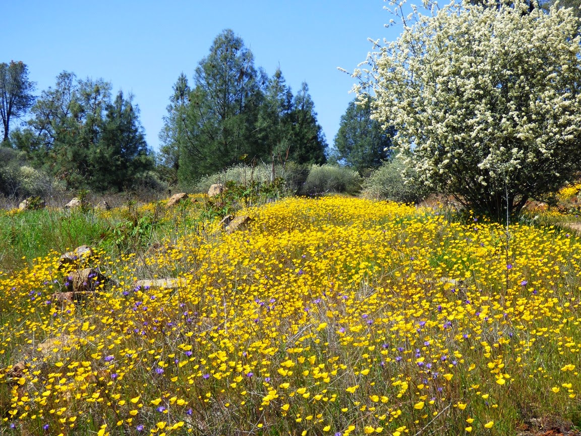
Ceanothus, Poppies, and Goldfields in the Red Hills area of the Sierra Nevada foothills.
Welcome to the Red Hills "Area of Critical Environmental Concern", a 7,000 acre preserve in the Sierra Nevada foothills near the village of Chinese Camp. We paid a visit today to see what flowers were out and about in this horrific drought year when much of the state has received hardly a quarter of the normal amount of rainfall. It's a fascinating area to explore, despite the somewhat plain appearance of the hills. The interest lies in the struggle for life in this tough environment.
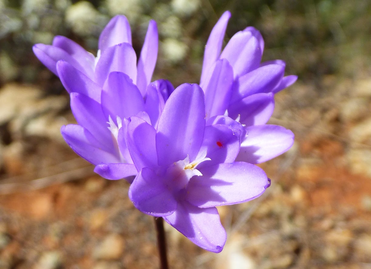
Brodiaea, or Blue dicks, Dichelostemma capitatum. Can you see the tiny mite in the flower?
It's not exactly harsh as far as the climate is concerned. Sure, it gets hot in the summer and the rain falls only in the winter and spring. But it rarely gets cold enough for snow, and the nearby hills include thick forests and brush. In the Red Hills, one is struck by the near total lack of grass covering the hillsides. Although oak trees are common throughout the region, few if any take root in the Red Hills. And there are sharp vegetational boundaries. The oak woodland and grasslands simply end, and the barren ground begins.
Indian Paintbrush
The problem is the soils. The underlying rocks are composed of serpentine and other ultramafic rocks derived from the Earth's mantle, the thick layer that lies beneath the oceanic and continental crust. The mantle rocks are rich in iron, nickel, chrome, and other metals that are toxic to most plants. The soils are also deficient in nutrients that plants generally need.
I don't know these diminutive flowers. Any ideas? I'm guessing Baby Blue Eyes (Nemophila menziesii)
These tough conditions mean that many plants can't grow on these soils, but others that are usually crowded out by grass and weeds can either tolerate the serpentine soils, or even thrive. Some 250 plants have been found in the Red Hills, including a number of endemics that are not found outside the serpentine exposures.
Five spot (Nemophila maculata): It's strange, but for all the years we've been coming out here, I have never noticed this species before. It is quite pretty!
For years the Red Hills were an abused landscape. Despite the proximity of the Mother Lode gold veins, very little gold was found in the hills (serpentine is not a gold-bearing rock). Nothing of value could be grown in the soils, and so the land was used as an illegal garbage dump, shooting range, and off-road vehicle course. As the uniqueness of the hills became better known, the Bureau of Land Management acted to protect and clean up the region. Today there are trails and parking areas for visitors. It is especially popular in the spring when the wildflowers are at their best. As mentioned before, the year has been horrifically dry, and we are indeed in the midst of the worst drought ever recorded. The flowers are getting started, but it remains to be seen whether they will thrive through the spring (there is a possibility of some rain this week).
As we left, we saw a particularly rich patch of poppies and brodiaea, but such richness was the exception. For the most part, the flower show hasn't really started yet (if it starts at all).

We left the Red Hills and headed south on Highway 49 on the way to Marshes Flat Road. Along the way I took a deceptive picture (above). Yes, it sure looks like an explosion of California Poppies. It's enough to cause one to say "What drought?". But take a look at the larger context of the picture (below)...

The flowers thrive because runoff from the pavement gives the soil the extra moisture they need. There are few flowers beyond the edge of the highway. Still, the color was beautiful, and I hope the rain this week will keep the show going a little bit longer before the long, hot and dry days of summer.

There were more (and different) flowers on Marshes Flat Road. We'll see those in another post.

Finding Gold in the Mother Lode (but not that kind): A bit of color in drought-stricken California

$
0
0
Our search for gold in the Mother Lode of the Sierra Nevada foothills was successful, but we weren't looking for that kind of gold. Yes, these gentle hills once hosted one of the greatest gold rushes in history, but the mines have been silent for many decades. Today, the Mother Lode is a tourist destination, and one of the attractions is the spring wildflower show. In the last post, we saw how a few endemics are showing up this week on the serpentine soils in the Red Hills Area of Critical Environmental Concern. Serpentine occurs in bands associated with the Melones Fault Zone which divides two major terranes, the Calaveras Complex and the Foothills Terranes. The Mother Lode gold-bearing quartz veins occur along this same boundary.
Highway 49 winds for 150 miles or so along the Mother Lode, and as we saw in the last post, the early flower shows are patchy, and are helped in places by runoff from the asphalt. The hills are green for the moment, but the green will not last long. In most normal years, 90% of the rain has fallen by now, and we have received maybe 25% of the rain we usually expect. It's the worst drought ever recorded. The green grass in these pictures will start turning brown in a few short weeks, and we can look forward to a hot, dry and fiery summer season.
So the early wildflowers are out, and if the expected storm arrives tomorrow, they might receive enough water to last a few more weeks. One thing I know from years of exploring southwest deserts, flowers in a dry place are precious to behold. So enjoy some of the color we discovered last weekend.
 There were occasional patches of Foothills Poppies.
The Redbuds were in bloom, adding bright splotches of purple or pink to the hillsides.
 Lupines seem to do well in lots of environments along the Mother Lode.
These pleasing-looking leaves are not good for touching or picking; this is the ever-present Poison Oak. The leaves are colorful and eye-catching throughout much of the summer season and into the fall.
We reached the Moccasin Creek area and saw where the Marshes Flat Road diverges from Highway 49 and heads west through the metavolcanics and metasedimentary rocks of the Foothills Terranes. These Jurassic rocks were deposited on the sea floor and scraped off into the vast subduction zone complex that once extended from Canada to Mexico and beyond. Today the rocks are tilted to an almost vertical attitude. On the meadowlands around Marshes Flat the rocks are rarely seen, as they are covered with fairly deep soils.
The road is a pleasant backcountry avenue that serves as access for several ranches. It's usually an uncrowded drive.
The metavolcanic rocks show up when the road starts down the steep slopes towards Don Pedro Reservoir. Although there was almost no water in the creeks, some of the slopes had pockets of blooming flowers, including these Shooting Stars.
 If these are Shooting Stars, are the two flowers below star-crossed lovers?
 Near a creek we found some wild onion blooming.
 And a moving rock. Seriously, why is there a track here, and what moved the rock?

We saw that the sun was getting low in the sky, and I had a lot of grading to attend to, so we headed home. I hope the blooms last long enough for another trip before summer sets in!

5.1 Magnitude Earthquake in Southern California near La Habra

$
0
0
Source: http://www.data.scec.org/recenteqs/
Lots of my relatives and friends in Southern California are reporting that they are feeling shaken up tonight. The magnitude 5.1 earthquake (revised from 5.3) took place about 2 miles east of La Habra, which may place it on one of the strands of the Puente Hills blind thrust system, according the the U.S. Geological Survey. My friends are reporting minor damage, mostly in the form of broken glass and fallen flat-screen televisions and monitors. The fault has been responsible for a number of historical quakes, most notably the 5.9 Whittier Narrows quake of 1987, which killed 8 people and caused around 350 million dollars of damage. The 2008 Chino Hills quake 5.4 may have occurred on the same system.

The event on the Puente Hills blind thrust was oblique, with reverse (compressional) and right lateral displacement, as shown by the focal mechanism from the quake (below). It is called a blind thrust because it doesn't have a clear surface expression which makes it difficult to assess the hazard level and the history of the fault. It is thought to be capable of generating a magnitude 7.2-7.5 magnitude event, which would have catastrophic consequences for the urban areas of Los Angeles and Orange counties. Such events are thought to have taken place around four times in the last 11,000 years.

Earthquakes such as those tonight serve to remind all Californians that their home is earthquake country, and all who live in the region must take this into account. The Puente Hills fault is just one of numerous active faults in Southern California. The San Jacinto, Santa Susana, Cucamonga, Elsinore, Whittier Hills faults, and the granddaddy of them all the San Andreas are all capable of causing great mayhem. Education and preparation are the best defense against tragedy. Here is a good place to start: http://www.data.scec.org/earthquake/preparedness.html.


The BIG ONE is COMING! Well, yeah, but...

$
0
0
The San Andreas fault in the San Francisco Bay area. The two reservoirs are Crystal Springs and San Andreas, which gave California's most important fault its name. Photo by Geotripper.

It seems like there has been a bit of shaking going on in California over the last few weeks. There was the 6.9 quake off the coast of Eureka on March 9, a 4.4 magnitude tremor in the San Fernando Valley on the 17th, and now the 5.1 magnitude quake in La Habra. It's enough to make people paranoid about quakes in general, and the BIG ONE in particular. Are these precursors to the BIG ONE? Are they relieving some of the stress that will prevent the BIG ONE from being so bad? We love to talk about the BIG ONE, and if the media outlets have their way, we will worry and fret about it, enough so as to tune in to their stations for more scary updates (to keep those ratings afloat). I've rarely been impressed by media coverage of earthquakes, and this week has been no exception. I've heard through tweets that some media outlets trumpeted official statements warning of bigger quakes to come in 24 hours while conveniently forgetting to mention the "5% chance of" statement that preceded the word "bigger".

Of course, in some ways it's worse. We're not waiting for the BIG ONE in California. We are waiting for the BIG ONES. The San Andreas fault gets lots of attention, but there are numerous active fault zones in California, and the San Andreas itself behaves like four independent fault systems. There was the devastating earthquake near San Francisco in 1906 that garners much attention, but there was an equally large quake near Fort Tejon in Southern California in 1857, and the Salton Sea region was shaken around 350 years ago. These different segments of the San Andreas seem to move every century or so. A huge quake shook the eastern Sierra Nevada in 1872, killing a tenth of the population in the Owens Valley (28 people). Each of these quakes were in the range of magnitude 7.7-7.9, although some estimates range as high as magnitude 8. Add to this list the 1952 Tehachapi quake (7.3-7.6), the Landers quake of 1992 (7.3-7.5), the Hector quake of 1999 (7.1), the El Mayor quake of 2010 (7.2, just over the border in Baja), and the Cascadia Subduction Zone quake of 1700 that no doubt affected the northernmost part of the state. It was very likely a magnitude 9 event.

I should mention that I successfully predicted these quakes. We discussed earthquakes and the "art" of earthquake prediction in my classes two weeks ago. We pointed out that psychics predict earthquakes all the time, and that they are never wrong (how wrong can you be when you say "I see a major city being devastated by an earthquake this year" without specifying a day or location?). To prove the point, I predicted that a quake would happen in northern California within a few days, and that another would happen in the south state as well. I make this prediction every semester, and I am rarely wrong. All such predictions are crap, of course, and do no one any good.


No one can predict earthquakes, and anyone who says they can is lying or is deluded. But we can predict where they will happen, and we can determine the probability that they will take place within a certain time frame, usually 30 years. This is the nature of the maps that I am posting here from the U.S. Geological Survey, the Southern California Earthquake Center, and the California Geological Survey. Such maps are a most useful tool for educating the public about where the greatest seismic risks are located in the state (note how distressingly close they are to the most populated parts). There is a lot more to the tectonic framework of our state than just the San Andreas fault!

It is interesting to me that since these probability maps came out in 2007, we've already had a 6.9 quake in northern California, and if you count just over the border, we've had our predicted magnitude 7 quake in 2010. It is important to note that neither of these events had any particular effect on the stress levels that have built up on faults like the San Andreas, Hayward and San Jacinto. They are still just as likely to shake in the next 25 years or so. What do we take from this? The quakes are coming, and we need to be prepared for them (start here: http://www.data.scec.org/earthquake/preparedness.html). Everyone who lives in California should have emergency supplies of water and food. Even if you live outside the high risk parts of the state, you will still be affected, as the energy grid will be damaged and emergency services we take for granted will be headed into the areas where damage is the worst.

Do these kinds of disasters make you rethink the idea of living in California? You could move to Kansas and put up with tornadoes. You could go to Nebraska and enjoy the Polar Vortex. You could go to Louisiana or Florida and deal with oil spills and hurricanes. You could move to Oregon or Washington and deal with volcanic eruptions. There really is no place that is free of natural disasters, and the processes that cause them may sometimes have the benefit of producing beautiful scenery and interesting geological outcrops. I'll pick California every time.


Geotripper is for the Birds: Life persists in the midst of horrific drought

$
0
0
It was on my morning stroll that I realized that Dry Creek was flowing. The creek has its headwaters in the Sierra Nevada foothills, and drains a region about thirty miles long before joining up with the Tuolumne River in downtown Modesto. It might seem extraordinary to be impressed by such a thing, but Dry Creek in recent decades tends to flow all year, from winter and spring rain runoff, and from irrigation overflow during the rest of the year. We had about two-thirds of an inch of rain yesterday, and in this drought year, that was finally enough to stop just infiltrating into the ground in the headwaters and begin flowing down the channel. In the twenty-five years I've been here, I've never seen such dry conditions. The rain is welcome, giving a last bit of moisture to fuel the growth of vegetation before the long dry season sets in. But it does little to alleviate the drought; we'd need something on the order of a foot of rain in the Great Valley and many feet of snow in the mountains in the next few weeks to fill the reservoirs.

As many of my readers know, I got a new camera a few months ago, and the powerful zoom lens has allowed me to explore a world that has been largely hidden to me until now: birds. Living in the Great Valley is wonderful for the access it provides to the incredible geological wonders of the Sierra Nevada, the Coast Ranges and the Cascades, but during the winter months when most field studies aren't happening the valley can seem a boring place. But not for the birds; for the birds, the valley is life itself. Millions of migratory birds winter on the valley floor, primarily in the federal and state bird refuges that have been established up and down the San Joaquin and Sacramento Valley floors. Over the last few months we have been frequenting some of the wildlife refuges, and the variety and number of bird species has been stunning to me (the neophyte birder). But the lingering drought is going to have an effect on their populations.

In some ways, the most surprising aspect of the bird-watching has been the variety of species I've found in my local neighborhood.  I documented some of them back in January in this post, but I have seen some more as the rain has finally come, and a few migrants have arrived back in the valley for the spring and summer. Here is a selection of the birds I have seen in the last week or two.
Cooper's Hawk (Accipiter cooperii)
The nicest discovery from this morning was a pair of Cooper's Hawks near Dry Creek (they could also have been Sharp-shinned Hawks, a closely related species; I invite corrections!). Even with the zoom lens, the raptors have been surprisingly shy about getting photographed. The hawks this morning were paying more attention to each other.
Western Bluebird (Sialia mexicana)
I saw quite a few Western Bluebirds during January and February, but I thought they had migrated higher up into the mountains, having not seen any for weeks. But here was one that was hanging out in the cow pasture a few blocks from my house. I love his colors.
Lesser Goldfinch (Carduelis psaltria)
There has been no lack of Lesser Goldfinches around my house. They are one of the most common visitors at our birdfeeders. This morning was the first time I've caught them foraging in the wild (the wild in this case being the grass along the highway north of my little farm town). The flowers in the background are Fiddlenecks and Purple Vetch.
Black Phoebes (Sayornis nigricans)
I love the little flycatchers in our area called the Black Phoebe. They are a western species, found commonly only in California, Arizona, and New Mexico, and many points south as far as Argentina. The Great Valley seems to be the northernmost end of their range. I'd never noticed them in the past, but I've seen dozens of them in the last three months.
Western Scrub Jay (Aphelocoma californica)
It's hard to miss the Western Scrub Jays around here. They're obnoxious and loud sometimes, and they're always chasing the other birds away from our feeders. On the other hand, they are one of the most colorful birds in our area. I always enjoy getting a close look at one.
Barn Swallow (Hirundo rustica)
One the recent arrivals in our area have been the Barn Swallows. They winter in Central and South America and migrate into our region for the summer. I photographed one for the first time just a few days ago. I'm seeing flocks of them lately building nests under the bridges around our irrigation canals.
Nuttall's Woodpecker (Picoides nuttallii)
I was very surprised to find a species unique to California living in my neighborhood. I thought "rare" endemics are hard to find. The Nuttall's Woodpecker hangs out in oak woodlands of California and nowhere else. I've now seen them several times in the walnut trees next to the cow pasture (and on telephone poles).
Great-tailed Grackle males (Quiscalus mexicanus)

The Great-tailed Grackles just recently arrived on the CSU Stanislaus campus. They arrived raucously, with one of the loudest calls I've heard during my bird travels of late.The males are dark black (above), while the females are brown (and much smaller).
Great-tailed Grackle females (Quiscalus mexicanus)

Yellowlegs Sandpiper (Tringas species); I don't know if it is the Greater or the Lesser.
I found the Yellowlegs Sandpiper in the slowly filling irrigation canal a few blocks from my house. They winter in our area before heading north into Alaska and Canada.
Yellow-rumped Warbler (Setophaga coronata)

I've briefly seen the Yellow-rumped Warbler flitting about in the grass on my campus, and even  chasing insects on my back porch one morning, but I walked out of my classroom on the third floor of our new Science Community Center the other day, and there was this little one right there in front of me. He politely waited until I had taken a few pictures before flying off.
Yellow-billed Magpie (Pica nuttalli), a Central Valley original

The Yellow-billed Magpie is endemic to the Central Valley. I see them all the time, and they are beauties. They are also in grave danger. The West Nile Virus reached our region in 2004, and the Yellow-billed Magpies were particularly vulnerable to the infection, with something like a 95% fatality rate. The population dropped by half in two years when the infection began. According to some web sources, they are rebounding somewhat from the disaster. I hope so; they are one of the prettiest of our local species.

So why all these birds on my geology site? Well, mainly because it's my blog, and I write about whatever interests me at the moment. But in the larger picture, the native species of a region are shaped by the geological forces acting on that area. These birds are adapted to the Mediterranean climate of the Great Valley and the riparian areas (rivers) and grasslands found within. They have survived hundreds of droughts in the past, and presumably are equipped to survive those of the present and the future. They have persisted through the vast floods which sometimes turn our valley into a vast lake. They are products of the geological forces shaping our valley just as surely as the rocks and sediment beneath our feet. And like so many of the wonderful geological sites in our state, they are interesting and often beautiful.

Oh no, it's Jar Jar Binks! No, It's Far More Special Than That...

$
0
0

Omigod! Somebody caught Jar Jar Binks! Okay, not really. But what the heck is this thing?

Say hello to Saurolophus, our home-grown California dinosaur! It is the last of the new teaching materials that we were able to purchase as part of renewing the teaching of science at Modesto Junior College. We ordered it months ago, but I guess there was a backlog of skull orders or something. It was like Christmas opening the box this morning.

Being last isn't what made it special. We have half a million people in our county, and I'm willing to bet that 99% of them don't know what it is or why it's important to them. Only one person got to be the first to find a dinosaur bone in California, and that was 17-year-old Al Bennison in 1937. He was exploring Del Puerto Canyon in the Coast Ranges along the western part of Stanislaus County looking for shell fossils when he found bones scattered on a slope. He showed them to his science teacher who reported them to the paleontologists at U.C. Berkeley. It was the first dinosaur ever found in our state. Bennison went on to a career in geology, and a few decades later discovered the most complete mosasaur skull ever found in California (see below). The mosasaur species even bears his name.
The Saurolophus was one of the last dinosaurs that ever lived on our planet, one the last groups in existence when the gigantic asteroid hit the planet (or when the volcanoes blew, or whatever else did them in). They lived in the latest part of the Cretaceous Period, which is well represented by sedimentary rocks in our region. The rocks are marine in origin, which tend not to be good places to search for dinosaurs, but sometimes a carcass would float out to sea.
Source: http://en.wikipedia.org/wiki/Saurolophus

The creatures were gigantic, on the order of thirty feet long, weighing several tons. They were plant-eaters, with teeth well-adapted to grinding twigs and leaves. Whether they swam or not has been a topic of discussion and debate. Some argue that they had few other defenses from predators, so that swimming was necessary to escape from being eaten. Others suggest that they lived in herds that provided protection.
Our skull collection is now a powerful tool for teaching the students in our region about the heritage of the land that they live on. In the picture above, one can compare the Cretaceous plant-eater with the Short-faced Bear skull, which lived in our area during the Ice Ages during the last two million years. It may have been the single largest mammalian land predator that ever lived, with a standing height of 11 feet. It would have made a grizzly bear look small in comparison.
The picture above shows our other recent arrival, the Mosasaur, similar to the one found by Al Bennison during the 1950s in the Coast Ranges just south of our county. It was not a dinosaur but was instead a seagoing reptile from the Cretaceous Period that may have snacked on sharks. It was around thirty feet long. It is probably the most formidable predator ever to inhabit our region.
To give a sense of scale, we have the Mosasaurnosing an Ice Age Sabertooth Cat skull (the cats weighed 700 pounds), and one of those wimps of the early Cretaceous, Velociraptor (which came out of Mongolia, not the Americas).

Dinosaurs certainly capture the imagination of our children (and not a few of our adults), and it is a good thing for our students to know that our county played an important part in the paleontological discoveries in our state. When students realize that one of their own (however long ago) made an important find, they also can visualize themselves as a paleontologist or geologist making important contributions to science.


Source: http://upload.wikimedia.org/wikipedia/commons/4/4b/Saurolophus_scalation.png


For the best source of information on dinosaurs and other Mesozoic reptiles of California, check out this book by Richard Hilton of Sierra College. It's the best resource out there for our state.

A Chance to See the Most Advanced Planetarium Star Projector in the Country! Friday, April 4 at Modesto Junior College

$
0
0
For those of you who live in Central California within driving distance of Modesto: If you follow my blog at all, you know that I have been enthusiastically describing the new Science Community Center along with the Great Valley Museum and Planetarium at Modesto Junior College. Many of you have been wondering when you would have a chance to see the planetarium (with the most sophisticated star projector in the country) in action. That time has come! This Friday the Great Valley Museum holding a major fundraiser, and will be offering four planetarium shows as well as tours of the nearly completed Great Valley Museum, including demonstrations of the Science on a Sphere. This is worth a bit of a drive if you are anywhere near, and the proceeds will support the Great Valley Museum in this, their most important year ever as they open up the new facility in a few short months. Come and join us! I'll be there, and will gladly offer tours of the geology department upstairs as well.

And They Became Gods in the Classroom: A Different Use for Monopoly Houses

$
0
0

It's getting well into the semester, and it's starting to wear on the students. A lot of them work at awful jobs which keeps them convinced that they need to do well in school so they can get a career doing something they enjoy. Some of them look a bit tired, as evidenced by the fact that their faces are planted on their desks, snoring. So what can you do in a geology lab to wake them up a bit? Let them play god!

Stream tables are the grown-up college equivalent of a sand box and hose. They allow students to simulate various hydrological situations, producing river deltas, alluvial fans, river channels and meanders, and shoreline wave processes. They set up a situation, a river channel or a dam, and then they turn on the pump and let the water run for awhile, observing the changes that take place. For some reason, the addition of Monopoly houses and hotels takes it to a new level. The students become capricious gods, determining the fates of their subjects on a whim, a flood here, a wild tsunami there.

I would hardly have noticed or commented today, but for once I set up a meander pattern in the sand and wandered away for a few hours with the water running. The stream did what streams will, and produced a sweet little meander cutoff , destroying the little Monopoly village in the process. It was sad for the Monopolians, but a great educational moment for the gods of the classroom!

Monopoly houses and hotels for years have taught our children to become corrupt hedge fund managers and criminal bank presidents (didn't you cheat too, or was it just me?). Why not put them to work to teach the dangers of ignoring geology too?

The stream table, by the way, is one of the best ways to detect a potential geology major. They will be hypnotized and work with the thing for hours!

DEATH, FIRE, EXPLOSIONS, END OF CIVILIZATION! YELLOWSTONE! OMG! Um, about that...

$
0
0
"Bison and many other animals are leaving Yellowstone in droves, and its (sic)prompting theories that minor earthquakes in the area could soon set off the Yellowstone Super Volcano." Source: click here

How many things can be wrong in one sentence? I count at least three or four. To begin with, the viral video that has the rumor mill going crazy apparently is showing a herd of bison rushing into Yellowstone National Park, not out. And I wouldn't be surprised that animals are leaving for lower elevations in any case. There is a decided lack of food higher up. They do it every winter.

Then, the word "theories" gets casually tossed into the mix. Speculation on the basis of very limited (or absolutely no) evidence is not a theory (a model or idea confirmed by extensive testing). The speculation in the sentence above doesn't even rise to the level of an hypothesis, which nearly all school children call an "educated guess". "Hypothesis" is reserved for ideas and models that are plausible.

The minor earthquake was a magnitude 4.7 event. The largest in thirty years. So what? It's still a minor earthquake. There are hundreds or thousands of earthquakes in Yellowstone every year, and the caldera hasn't exploded. There was a quake with a magnitude of 7.3-7.5 back in 1959. That quake, which killed 28 people was thousands of times more powerful than the quake last week. Why didn't the caldera explode back then?

It comes down to ignorance of basic geologic principles on the part of journalists and the fear-mongers on the web. Having a little bit of knowledge is sometimes as damaging as having no knowledge. People have been told by cable channel documentaries over and over that Yellowstone is a "supervolcano", which was never a geologist's term. They pick up that there was a truly colossal eruption 2.1 million years ago, another 1.3 million years ago and another 640,000 years ago. OMG it's a pattern and we're all going to die! Next week!

The gentle fact is that Yellowstone has not had a volcanic eruption in 70,000 years. There is indeed a large body of molten magma beneath the park, but it has been there for millions of years, and there are currently no signs of unusual activity. From studies of calderas around the world, it is clear that many warning signs taking place over centuries would give humans plenty of time to figure out how to deal with the eventuality of a major eruption.

There are many things to worry about in the world these days, but a gigantic eruption at Yellowstone is not one that I lose sleep over. When you read someone's frantic post about "the BIG ONE" shaking up Southern California or supervolcanoes destroying civilization, make use of one of the most powerful human tools ever invented. Take to the internet, the greatest repository of human knowledge ever constructed, and investigate.  Don't seek out the idiots who post rumors and innuendo. Find out what the real geologists are saying before hitting that "share" button. Don't get Snoped by your more intelligent friends. It's really embarrassing.

And that goes double for "journalists". What you have done with is non-story is irresponsible. At the very least, read an analysis by a responsible blogging expert like Erik Klemetti at Wired before writing anything on your own.
Viewing all 1203 articles
Browse latest View live