Quantcast
Channel: Geotripper
Viewing all 1203 articles
Browse latest View live

The Green Flash, the Green Rim, and Coastal Sunsets

$
0
0
I'm in a beautiful place, no doubt about it. I'm in central Oregon on the Siuslaw River visiting for the holidays, exploring new terrain that I've never really seen before. Luckily, we have the time to linger for a few days instead of rushing home, so it actually feels right to sit on the porch and just enjoy life and my relatives (whom I love spending time with).
And what a porch! I took advantage of clearing skies to watch the sun set tonight. I've got the new camera and I am still learning its capabilities, so I decided to catch the whole drama of the sun disappearing below the distant horizon. I also hoped to catch the legendary "green flash", which I have never seen (despite my hopes in previous posts).
I probably still haven't seen it, but I was reading about these things, and noted that a "green rim" can sometimes be seen as well. If my camera is delivering true colors, I think I captured the green rim at the very least, across the top of the disk of the sun.
 The green flash is a sudden flash of greenish light above the sun at the moment of sunset, and it is said to last only a second or so. As the sun dips into the horizon, the layers of the atmosphere will cause some of the sunlight to be refracted, with red and orange on the lower parts of the disk along with green (and rarely blue) across the top.
If I caught the flash at all, it was probably here, as this was the only green I could see while I was snapping the pictures. I leave it to the judgement of those out there who have seen the green flash before as to what I caught this evening. I welcome your thoughts and observations!


The Tormented Lost Souls in Hades? Or Maybe the Denizens of the Largest (?) Sea Cave in the World

$
0
0

You've seen the bumper stickers, no matter where you've been in the country: Trees of Mystery, Wall Drug, South Dakota, and Mystery House of just about anywhere, and of course, Sea Lion Caves. I've never fallen for the allure of said bumper stickers, but Sea Lion Caves just happened to be 11 miles north of where I'm at this week, and there is definitely something geological about the place, so I gave in and checked it out yesterday.

The draw of the place is of course the fact that a great many Stellar's Sea Lions congregate inside the vast opening which is said to be the largest sea cave in the world. I pulled up and looked around. Big signs? Check. Gift Shop? Check. High ticket cost? Check. Yup, all the attributes of these kinds of attractions.

Still, the setting was beautiful. The site is on a high sea cliff on Oregon's Highway 101 eleven miles north of Florence, and just a mile or two from Heceta Head Light House and Devils Elbow State Park, two places I can highly recommend (they are part of a single park now).

From the gift shop, you walk down some steps and head down a paved path to the 200 foot elevator that drops you into the viewing area within the sea cave. There is no view or sense of what lies below, given the steepness of the cliffs.

I looked to see if anyone has photographed the sea caves from the outside, and couldn't find any, so I went to GoogleEarth for help. Here is what you can see from there...the cave has three openings and extends for 1315 feet, making it the third longest sea cave in the world. They also have a claim about being the largest sea cave in the world by volume, though others make claims as well: check this link out, for instance. I can't really judge one way or the other, but noticed that the Riko-Riko cave included a submerged portion of the cave in its measurement.


In any case, the cave at Sea Lion Caves is impressive. The ceiling of the cave is 125 feet up. The little tan-colored dots on the rocks in the first picture are full grown sea lions. I don't have any idea how they climb up onto those rocks.

The noise is other-worldly, and if I were hearing it without the context, I would swear it was the tortured lost souls in Hades crying out for mercy. The vast opening echoes and amplifies the noise of around 200 sea lions.


So, is it worth it? That's a tricky question to answer. The cavern is huge, and is fascinating from a geological perspective. The Stellar's Sea Lions are certainly a charismatic animal species, and it is no doubt a spectacle to see so many of them gathered into one place. But responsible stewardship of the species makes it absolutely important to not bother or interfere with the animals, and that means that there is no exploration of the caves. One gets only the one view from the platform. There are some interesting exhibits to spice up the experience, including a fossilized skeleton of one of the sea lions that is at least hundreds of years old, and a full skeleton of another. There is a stairway that climbs to the third and higher entrance to the cave that provides a fine view north towards Heceta Head Lighthouse.

It's a capitalistic enterprise, so they presumably charge what the market would bear ($14 for adults and less for kids), and if I had a large family I would balk at the price. Still, I would say that it was worth the price to see such a huge cave, despite the limitations. It's the kind of place that I appreciate and am impressed by, but I pretty much need to see it only once.

So, don't be afraid to check it out if you are in the area. If you want to see the sea lions, but don't have the monetary resources to pay the admission fee, stop in the pullout just north of the parking lot and look to the base of the cliff. I've seen a big crew of sea lions down there on every occasion I've been by (below).

Happy New Year From Geotripper! A Resolution: Follow Those Dreams!

$
0
0
I've never been one for resolutions. Changes in my life tend to happen at the various times when the need for change becomes apparent and I try acting on them as a result. That being said, the new year began a few moments ago, and a few things occurred to me.

First off, go and check out Andrew Alden's blog post on geological resolutions (click here). There is some great advice there.

And then consider Ollie Hopnoodle's Haven of Bliss. Never heard of it? That's a shame, because it was a gem of a movie, written by Jean Shepherd, who also wrote "Christmas Story", the classic tale of Ralphy and his quest to get hold of a Red Ryder BB Rifle ("You'll shoot your eye out!"). "Ollie Hopnoodle" follows the same characters a few years later as they take their family vacation. The thing is, they always went to Haven of Bliss, a fishing lake up in Minnesota somewhere. Year and after year. The story was great, but don't do that! Don't get caught up in sameness and habit!
The world is so big and there are so many wonderful things out there to explore. Some are far away, but some as as close as your own backyard. Resolve to try something new, and to see someplace new. This has been one of the greatest years in my life. I was given the precious opportunity to float down the Colorado River with my brother and his family, and every minute of each of the 17 days was a gift that I can never forget. There were moments of unspeakable terror, but hours and days of bliss as well, as I finally achieved one of the great dreams of my life.
But here's the thing: the second great discovery of my past year was a big surprise, because it was literally in my backyard. I've always kind of liked birds, but never really learned much about them, and knew little of the species that live in my area.

A new camera with a pretty good zoom lens has taught me that there are many discoveries to be made just outside your door. I've been amazed at the variety of birds that live where I do. It's a new favorite activity these days, photographing the little avian dinosaurs.
So the thing is, if you think in terms of resolutions, I say try something new and different. It can be one of the big dreams you've always had, but never believed it could be achieved; you can start right now to make it happen. Or make a small change and discover something new about where you live, whether it's to learn something geological, or ornithological, or biological. Your life will be richer either way.

The Stacks are Odded Against Us! Subduction's Gift in Southern Oregon and Northern California

$
0
0
Sea stacks on Highway 1 near Elk, in Northern California
Sea stacks are isolated rocky islands found along rugged coasts where wave erosion is intense. They form for a variety of reasons (from glaciers in places like Maine, for instance, or from lava flows in Hawaii). If the rocks vary in composition over short distances, some outcrops will be more resistant to erosion and may last longer against the onslaught of the breakers. This is the gift of subduction in areas like Oregon and Northern California. Rocks exposed along the coast tend to include a hodge-podge of ocean-related rocks, including graywacke sandstone, shale, basaltic ocean crust, limestone, chert, and the occasional seamount (seafloor volcano). Some are really tough, and others are easily eroded.
Sea stacks at Point Orford in Oregon
Subduction happens when a thick slab of oceanic crust and upper mantle (the lithosphere) sinks beneath another slab of lithosphere. The crustal material is drawn into the mantle where some of the rock may melt, producing volcanic activity at the surface above. In Oregon and Northern California the oceanic lithosphere is sinking beneath the edge of the North American continent along what is known as the Cascadia Subduction Zone. The volcanoes of the Cascades Range are the very visible evidence of this intense geologic activity.

Subduction zones produce some of the worst of geologic disasters, including massive earthquakes and devastating tsunamis. But the deformation of the Earth's crust also causes the formation of mountains and rugged coast lines that make some of the world's most beautiful scenery. And that is where today's post originates. I had the privilege of spending a few days making my way south along Oregon 101 and Highway 1 in Northern California on my way home from Christmas visits, and we saw a stunning variety of shoreline features including the sea stacks that I am emphasizing today.
Sea stacks near Brookings, Oregon, I think. Anyone recognize them?
The Cascadia Subduction Zone has also collected bits and pieces of continents from elsewhere (called exotic terranes) and mashed them into the edge of the continent. The rocks of the Klamath Mountains in southern Oregon and Northern California originated in this fashion. These metamorphic rocks contribute to the extreme variety of rocks found along the coast.
Restless seas in the morning at Fort Bragg in Northern California
The weather was supremely perfect for viewing the scenery (if not an utter disaster in the making for water-planners; the ongoing drought is the worst ever). There are storms out there somewhere because the waves were quite large at times.
At the mouth of the Navarro River just south of Mendocino in Northern California
This isn't the first time I've used the dumb pun above; I put up a series of sea stack pictures last year when I made my first journey down the Oregon coast in many years. The thing is, these stacks are completely different. There is a lot of very spectacular scenery, and every trip along that route will be a different experience.
Sea arch in a stack at Navarro Beach in Northern California near Mendocino.
Navarro Beach was our last long stop. We actually had to get home at some point after two weeks on the road. It was a truly beautiful day. Happy New Year to all!
Sea stacks at Navarro Beach on the Northern California coast.

Birds of My Neighborhood: Geotripper Explores the Home Base on National Bird Day

$
0
0
Cedar Waxwing (Bombycilla cedrorum)
I'm told that today is National Bird Day (thanks, Randall), which was convenient to today's post since I was already collecting pictures of birds from my last two days of neighborhood exploration. It was meant to be an addition to my post several days ago describing the surprising diversity of birds in my home town, despite the winter chill. The Great Valley of California turns out to be quite the refuge for winter survival of a great many avian species. We are far enough south to avoid the frigid chill of arctic storms, and most of our storms are gentle compared to the blizzards experienced in other parts of the country (with the occasional exception, of course).
Cedar Waxwing (Bombycilla cedrorum)
But really, birds in a geology blog? What connection could there possibly be with the study of rocks, minerals, and fossils? Oh, yeah, fossils. Birds have been an important part of the web of life on this planet for more than 100 million years, and were the last of the major families of terrestrial creatures to emerge. They are literally the last dinosaurs, but as such they are particularly successful and diverse dinosaurs, and most certainly not a failing evolutionary dead end. And they apparently almost displaced mammals as the apex predators in the terrestrial environment several tens of millions of years ago.
American Robin (Turdus migratorius)
After the "regular" dinosaurs met their demise at the end of the Cretaceous Period (possibly as a result of an asteroid impact), the subset of feathered avian dinosaurs were some of the survivors that expanded and evolved to fill a world with many empty environmental niches. Mammals were quickly evolving to fill those same niches, and for a while there were some gigantic land birds that were the top predators of their time. Eventually their places were taken by large mammals and crocodile-type reptiles, but the birds mostly took to the air and became one of the most diverse vertebrate animal groups in the world today.
Yes, you "mock" me now, but imagine me being 10 feet tall. That would change your tone in a hurry...


Today, birds are an integral part of any terrestrial ecosystem, and their relative health is a barometer for all life on our planet. There is a great joy in observing the incredible diversity of these fascinating creatures, but the diversity and future survival of these animals is threatened from habitat destruction and hunting. That's probably more true in the Great Valley of California than for about any other place on the planet.
Western Bluebird (Sialia mexicana)
The Central Valley (the term is interchangeable with Great Valley) is one of the world's great savanna-grassland-riparian habitats and was once a paradise for numerous bird species and other animals. The vast wetlands were historically a critical stop on the migratory flyway for hundreds of species. Unfortunately for the birds, the rich soils and ample water supply from Sierra Nevada rivers have meant that most of the valley has been co-opted by humans for agricultural development. Only 5% of the original habitat still exists. This has meant huge changes in the ecosystem, with many species that have disappeared, and others that have prospered. 
Oak Titmouse (Baeolophus inornatus)
Humans added all kinds of mayhem by introducing new bird species for spurious and stupid reasons. One of the worst: a man in the 1890s who resolved to introduce to the New World all the birds mentioned in the works of Shakespeare. He arranged for the release of several hundred European Starlings in Central Park. They have since spread across the continent like a plague, displacing dozens if not hundreds of species of native songbirds. Other birds arrived as pets which subsequently escaped (flocks of parrots live in the LA Basin, for instance).
Black Phoebe (Sayornis nigricans). Identification thanks to Callan Bentley (Mountain Beltway) and his friend Seth.

Despite the horrific pressure brought to bear on the native species of California, there are many bird varieties still to be seen in the Great Valley. I have become aware of this delightful fact over the last few weeks as I explored my own local neighborhood with a new camera with a nice optical zoom. We've always had a feeder in the backyard, which caused me to think that the only local birds were goldfinches, house finches, scrub jays, and mockingbirds. A new habit of walking around the nearby cow pasture has revealed a real menagerie of beautiful and interesting species.
Scrub Jay (Aphelocoma californica)

So today's post (and my post from several days ago) is a celebration of National Bird Day, with fifteen species that I was able to photograph in just two days of strolling around my neighborhood. Some I've seen before, and many I have never noticed. I never would have guessed that two, and maybe three species of woodpecker live on my block!
Northern Mockingbird (Mimus polyglottos)

Some of the birds are skittish and shy, and others look at you and don't give a rat's posterior that you are standing there photographing them. And then there are the crows and ravens. You look at them and you can see them thinking and hear them talking about you...they are said to be the smartest of all birds, and I pretty much accept that way of thinking.
Nuttall's Woodpecker (Picoides nuttallii)

And never forget: these little fellows are dinosaurs. Only they're smarter...

The Finest Science Center in the Great Valley Needs a Museum Director

$
0
0
If you follow this blog at all (and many thanks if you do!) then you know that we recently occupied what I think may be the finest teaching facility of its kind in the Great Valley of California, and maybe in the entire state. The Science Community Center at Modesto Junior College is a monument to the importance of science education, with state-of-the-art labs and classrooms for biology, astronomy, chemistry, physics, and the earth sciences, as well as a fully equipped observatory, and the most technically advanced planetarium projector in the United States (seriously, it's the newest generation, and we were the first to have it installed). And very soon we will open the Great Valley Museum and Outdoor Education Laboratory. The museum will have exhibits emphasizing the unique biology, paleontology and geology of the Great Valley, and will include the unique teaching tool called Science on a Sphere.

And we need a museum director.

The position announcement was posted this morning, and can be found here: https://yosemite.peopleadmin.com/postings/987. If you are a talented person who knows and loves science, but can also navigate the depths and passages of a college and state bureaucracy as well as excelling at fundraising, you may be the person we need to lead our school and our valley into a new era of science excellence. Contact me or the Human Resources office at Yosemite Community College District if you have questions.

Science Education Leaps Forward in California's Great Valley: Want to be involved?

$
0
0


I announced this opening on Geotripper yesterday, but I thought that this press release would provide some more detailed information about the position. This is an exciting time for science education in our valley, despite the disturbing anti-science currents across our country. If you want to be involved in one of the most dynamic science education efforts in California, think about applying for this position:

Press Release:
The Great Valley Museum of Natural History at Modesto Junior College seeks a new Director to oversee all day-to-day and fundraising operations. 


Situated in the heart of California’s Central Valley, the Great Valley Museum (GVM) serves to educate and promote the study of science and nature throughout our service area of approximately 500,000 people.  The GVM serves as the community education arm of the Science, Mathematics, and Engineering Division of Modesto Junior College, providing educational programs for children grades Pre-K through 12 both on-site at the GVM and at area schools through our extremely popular Traveling Teacher program.

The GVM offers Central Valley ecosystem displays, a California Natives exhibit, a live animal vivarium, the Discovery Room full of hands-on materials, a backyardexhibit, and full-body taxidermy of animals from around the world.  The GVM has a long history of assisting classroom teachers. Our expertise is in bringing science and nature to students throughout the community.  Using the California Science Standards as a guide, we offer a multitude of programs on science and nature topics.  Tours of the Museum showcase our many exhibits and displays. We are flexible and mobile and we will provide these programs at our Museum, parks, classrooms or other educational sites.

In April, 2014, the GVM will move into its new home on the ground floor of the brand-new Science Community Center on MJC’s West Campus.  This location will provide immediate access for MJC’s science students to study the flora, fauna, and ecosystems of our area, from the Sierras to the valley floor, and to utilize the Science-on-a-Sphere display (from the NOAA) for the study of Earth and space sciences.  Operated in concert with the GVM, and also overseen by the GVM Director, is our brand new, state-of-the-art planetarium with 107 seats below a 40-foot dome housing both a Zeiss ZKP-4 LED/fiber-optic star projector and the Zeiss Velvet Digital Projection system with Uniview software.  The MJC Planetarium will be a sought-after destination for teachers and their classes from throughout our community and within the college itself, and for families and groups seeking exciting science learning opportunities and events.

Adjacent to the GVM (currently in design) will be an outdoor education area with native plants, an aquatic ecosystem, geology specimens, a greenhouse, and a shaded gathering area.

The Director of the Great Valley Museum will supervise all GVM staff, currently consisting of two full-time employees, a dozen traveling teachers, and a cadre of volunteer docents and helpers.  In addition, the Director serves ex-oficio as a member of the Great Valley Museum Foundation Board and is charged with oversight of all fundraising activities.  With the new facilities, the GVM is perched to take off to great heights and expand its staffing accordingly, based on vastly increased visitation, on-site classes and planetarium shows, and increased donations from the community and corporate sponsors.  The GVM seeks a leader with the skills and vision to fully realize this next phase of growth in its new home.  The ideal candidate will couple a background in science, education, and/or museum studies, with success in fundraising and collaborative leadership of a diverse staff of dedicated employees and volunteers.

Details of the position, including minimum qualifications and application procedures, can be found at https://yosemite.peopleadmin.com/postings/991.  Interested applicants must create an account and submit their applications electronically. 
Closing date = February 10, 2014, 11:59 pm.

For additional information about the Great Valley Museum, visit our website at http://www.mjc.edu/community/resources/gvm/index.html.  Also visit the Science, Mathematics, and Engineering Division website at http://www.mjc.edu/prospective/programs/sme/ for more information and a photo of the beautiful new Science Community Center.

Questions can also be directed to museum staff members Molly Flemate (flematem@mjc.edu, 209-575-6674) and Tana Dennen (dennent@mjc.edu, 209-575-6196) or to Brian Sanders, Acting GVM Director, as shown below.

On the Most Inaccessible Mountain Range on the Planet: Walking the Mid-Ocean Ridge in the Marin Headlands

$
0
0
What is the most inaccessible mountain range on planet Earth? The Himalaya? The southern Andes? Some mountain range in the Antarctic wastes? Nah. The most inaccessible mountain range is so difficult to visit that only a handful of humans have ever even laid eyes on it. It lies at the bottom of the sea, and is called the Mid-ocean ridge. It dwarfs the other major mountain ranges around the planet, extending for around 45,000 miles, enough to nearly circle the planet twice.
The Mid-ocean Ridge is not a high mountain range, maybe 5,000-10,000 feet high, but it lies thousands of feet beneath sea level except in extraordinary places like Iceland. Iceland is part of the Mid-ocean Ridge, but probably also includes magmas rising from a hot spot, giving it the extra elevation to rise above the waves.
So mountaineering on the Mid-ocean Ridge is beyond most mortal folk, but you can explore the surface of the ridge in a few places around the world where oceanic crust has been scraped off the sea-floor and accreted to the edge of a continent. One such place is on the Marin Headlands just north of San Francisco (I noticed in the geoblogosphere that Chuck Bailey at W&M Blogs has recently described another such spot in the somewhat more exotic Wadi Jezzi in Oman - Check it out!).
Some of the most spectacular scenery along the most beautiful coastline in the world can be found on the Marin Headlands (this post is actually a continuation of a blog series I started before the Christmas holidays). When you cross the Golden Gate Bridge headed north, take the Alexander Avenue offramp and follow Conzelman Road onto the headlands. Immediately you are treated with a gorgeous view of the Golden Gate Bridge, but the real story is behind you in the roadcuts. There are ribbon cherts (a form of deep ocean sediment derived from myriads of one-celled creatures called diatoms) lying directly on ocean-floor basalt. Lay your hands on the contact between the two and you are touching the surface of what once was part of the greatest mountain range on planet Earth!
The Marin Headlands don't lack for inaccessibility themselves. The coastline through this region is exceptionally rugged, with steep cliffs that slope directly into the surf. San Francisco Bay lies hidden behind the peninsula, and the ruggedness of the region prevented its discovery for many years (nearby Monterey Bay was visited as early as 1542, but San Francisco Bay was not discovered until 1769).
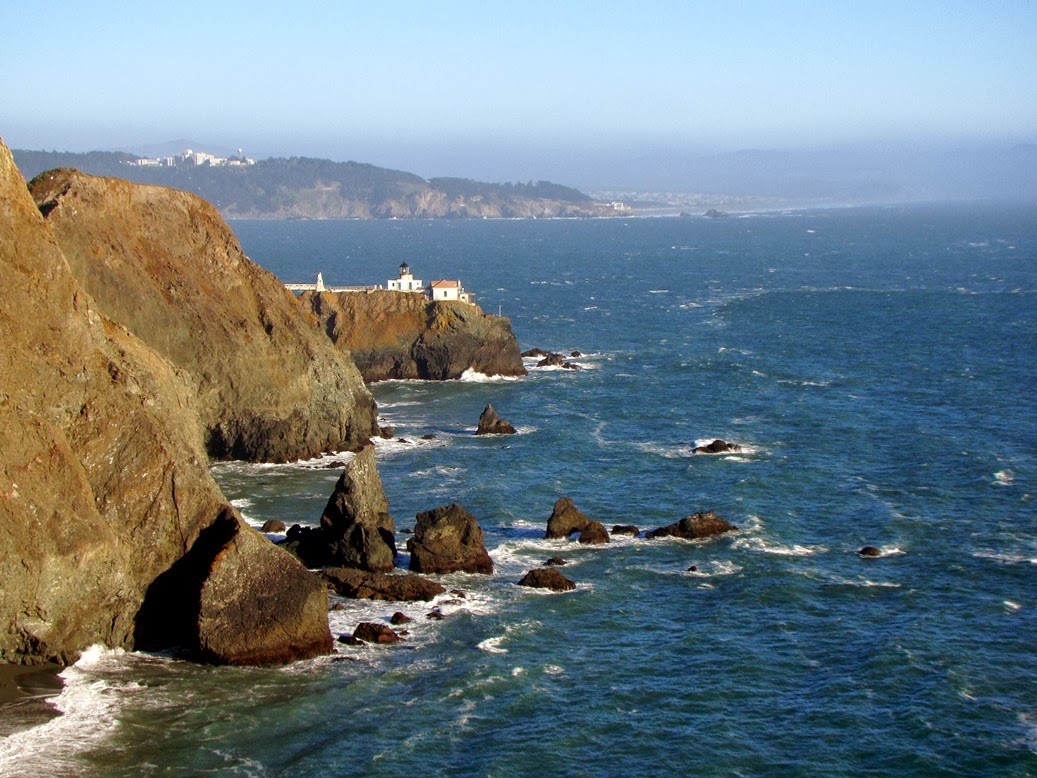
The odd looking cement structures found around the Marin Headlands are kind of a jarring reminder that the history of this region is not that of long-protected wilderness sanctuary. When World War II was being fought, San Francisco Bay was one of the most important strategic strongholds for the entire Pacific Theater of operations. There was the harbor itself through which much of the fleet operated, factories and ammunition depots, and the inland agricultural areas. That and a huge civilian population. The hills above the Golden Gate were studded with huge cannons and guns that could wreak devastation on any enemy flotilla that tried to enter the harbor. Below is Battery Mendell, just north of the Point Bonita Lighthouse.

The Marin Headlands region is a stunningly beautiful place with a fascinating geological story. The area is protected as part of the Golden Gate National Recreation Area, which is a level of protection that is more or less equivalent to a national park. It is certainly a popular destination, but it's usually possible to find some quiet corners, especially if you are willing to hike a little. While in the area, don't pass up Muir Woods National Monument. It's one of the most-visited monuments in the country, but wandering through the Redwood forest, it's not hard to see why.

Science on Screen at the State! Whale Rider, Sunday January 12 at 3:00 PM

$
0
0
For my Modesto area readers: I've been involved for the last 18 months with an innovative program at the State Theatre called Science on Screen. The program offers movies with science themes and speakers who can offer additional perspective (and sometimes "constructive" criticism) of Hollywood's version of science. I want to invite you to attend tomorrow's event, a screening of the movie Whale Rider, and a presentation by Kimberly Stevenot.

Read below for more information (from the State Theatre Facebook page):

Topic: Does Saving a Culture Sometimes Rely on Challenging its Traditions?
 

Science On Screen begins the New Year with Whale Rider, a magical film about a 12-year-old Maori girl who dares to defy tradition and challenge her family, only to bravely fulfill her destiny as the leader of her village. This family-friendly film is rich in its imagery, its depictions of the Maori tribe, and in its own bravery in seeing the need for cultures to change, possibly in order to save them. The speaker is Kimberly Stevenot, a noted Miwuk traditionalist, basket weaver, artist and teacher who will discuss tribal customs and cultures, and will also have native regalia, jewelry and baskets on display in the lobby. The Miwuk are native Americans who have long lived in the foothills of the Sierra Nevada, the Sacramento and San Joaquin valleys, and the Sacramento-San Joaquin Delta.

Science On Screen at The State Theatre is made possible through a grant by the Coolidge Corner Theatre, with support from the Alfred P. Sloan Foundation. This pioneering program creatively pairs Hollywood films with notable experts from the world of science, technology, mathematics and medicine. Interactive activities and displays in the lobby from 2 to 3 p.m.; Ms. Stevenot, who will speak at 3, will return for a Q&A following the screening of the film.


Doors and interactive activities at 2; presentation and film at 3 p.m.; Q&A to follow film
 

Admission: $8 or $6 for student with ID
 

Group discounts are available for classes and organizations (comprised of 10 or more) wishing to attend films in the Science On Screen series. For more information please call State GM Sue Richardson at 209-527-4697.

Where the Sierra Nevada Rises from the Sea: Point Reyes National Seashore

$
0
0

Drake's Beach, with outcrops of Purisima Formation that reminded early sailors of Dover.
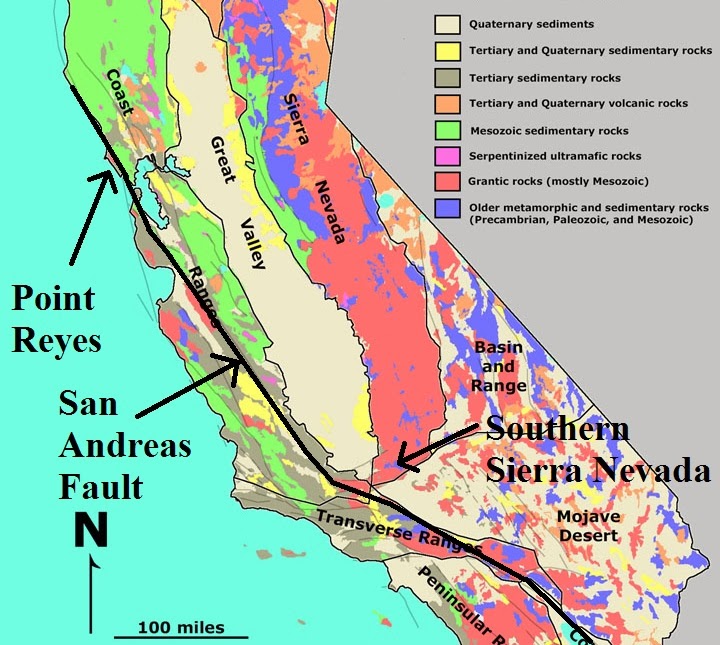
Around 30 million years ago major parts of Central California were in Southern California. It's about that "simple". Around 29 million years ago a major restructuring of plate boundaries was taking place along the Pacific Coast. A subduction zone (convergent boundary) that had influenced the California margin for nearly 200 million years, forming the granitic rocks of the Sierra, was changing over to something new. It was transforming, so to speak.

For many millions of years, oceanic crust and exotic terranes were carried eastward towards the continent, only to be forced beneath the edge of North America (subducted). Eventually the source of oceanic crust, the East Pacific spreading center, made contact with the convergent margin and subduction ended. Because of the relative motion of the two plate edges, a new fault system developed, the San Andreas, and a portion of Southern California began to move northwestward along the new fault. Such zones that divide crustal plates from one another are called transform boundaries. Granitic rock that had formed as part of the Sierra Nevada Batholith was sliced off from the south end of the province and was carried north several hundred miles (see below). The displaced granitic rocks are referred to as the Salinian Block.
The Point Reyes Peninsula is one of the more intriguing corners of California. It's connected to the California Coast Ranges after a fashion but it is a world apart. Tomales Bay, Olema Valley, and Bolinas Lagoon mark the location of the San Andreas fault. The epicenter of the infamous 1906 San Francisco Earthquake was close to Point Reyes, and offsets totaled close to 20 feet during the magnitude 7.8 seismic event.
The peninsula is protected from development as Point Reyes National Seashore, and is a haven for wildlife. During my visit several years back I captured my best shot ever of a California Quail. On our way to the beaches, we saw a herd of Tule Elk.
The Peninsula has several distinct geological sections. The mountainous terrain of Inverness Ridge is composed mostly of the granite and metamorphic rocks of the Salinian Block. Much of the western and southern parts expose sedimentary rocks of Miocene and Pliocene age. During the journey northwest from Southern California, the peninsular was submerged beneath the ocean waves. Active dune fields can be found along the extensive beaches of the peninsula.

Drake's Estero is an interesting feature. The branching arms of the bay suggest that it is a submerged river valley. The shallow water has proven to be a good spot for oyster farming, and the 80 year old business is embroiled in a battle with the park service over land-use issues.
Source: USGS (http://pubs.usgs.gov/of/2005/1127/)
From the headland of Point Reyes, Point Reyes beach stretches northward for around 10 miles, making it one of the longest stretches of sandy beach in Central or Northern California. As popular as it might have been, the fierce waves and very cold water make for uncomfortable water play.

The rocky headland where the lighthouse is located is composed of granitic rock and some of the overlying late Cenozoic sedimentary rocks. The lighthouse is visible from as far as 24 miles away, but fog obscures the view for around 140 days a year. Winds are nasty (highest recorded was 133 mph), and the temperature generally hovers between 50 and 60 degrees Fahrenheit all year.

Reaching the lighthouse requires descending 300 steps, but during the rare clear days, the spot is one of the best in California for whale-watching. Expect crowds on the nice days...

Steps leading to the Point Reyes Lighthouse
In the next post, we'll explore the more inland part of Point Reyes National Seashore, mainly Tomales Bay and Bolinas Lagoon.
Point Reyes Lighthouse, constructed in 1870

Birds of My Neighborhood: Geotripper Explores a Bit of the "Original" Great Valley

$
0
0


In the last few weeks I've been documenting the bird species in my local neighborhood, primarily around the cow pasture that sits a few blocks from my house. Much to my surprise, I was able to identify at least 25 different birds in a few days of walking, and I blogged some of my favorite pictures so far (here and here).
A cow pasture and an urban neighborhood feel a bit out of place, like an environment where the species make do, and opportunistic species like crows, pigeons and starlings dominate. We decided to go looking for birds in a more "natural" setting and headed south to the San Luis National Wildlife Refuge. We were greeted by the hawk on the entrance sign.
I say "natural" in quotes, because the refuge is not exactly a section of of the valley that retains its primeval wilderness nature. There are very few of those areas still in existence. It is instead an effort to return some reclaimed agricultural lands to wetlands status, and the location and pattern of the swamps is carefully regulated to encourage natural plant growth to allow the migratory and native birds to flourish. In essence the refuge is farming birds. That sounds kind of negative, but it's not meant that way. The wetlands stops on the Pacific Flyway have been decimated by agricultural and urban development, and this is a great effort to undo some of the damage.
We headed out a short looping auto tour off of Landers Road and slowly made our way down the dirt road. The swamps had recently been flooded, and birds were all over, although they tended to be rather shy. A great many of our shots are at extreme zoom.
The American Coots (Fulica americana) were present in abundance. They seemed the least disturbed by our intrusion.
There was a Great Blue Heron (Ardea herodias) in the reeds, but I only got a few shots before it headed deeper into the marsh.
I think the bird below is a Say's Phoebe (Sayornis saya) that lurked in the low weeds and grass at the edge of the capabilities of my camera. With the distinctive orange belly I thought it was a robin at first.
 The bird below may be a sandpiper or willet (any assistance appreciated!).
And finally I got a few shots of the most common bird that we could see that  day, the Red-winged Blackbird. This pair was kind of meek about showing off their red plumage...
 But the one below had no problem!


Magnitude 4.4 Earthquake in Southern California

$
0
0

There was a magnitude 4.4 earthquake in southern California this morning at 1:35 AM, centered about three miles north of Fontana along the southeastern edge of the San Gabriel Mountains in a complex zone where three major fault systems intersect: the San Andreas, the San Jacinto, and the Cucamonga. Very minor damage was reported.

The picture above was taken relatively close to the epicenter area and shows the incredibly steep and rugged topography produced by the faults that have been active in the region. Cucamonga Peak on the left rises to an elevation of nearly 9,000 feet. The mountains have been pushed up in a very short period of time geologically speaking, only a few million years.
Source: http://www.cisn.org/shakemap/sc/shake/11413954/intensity.html

The focal mechanism suggests right lateral motion, consistent with the expected stresses on the San Jacinto fault.
Source: http://earthquake.usgs.gov/earthquakes/eventpage/ci11413954#scientific
There doesn't seem anything particularly unusual about the quake. As always, this region is traversed by several active faults that are capable of generating large damaging quakes. The San Jacinto has produced nearly a dozen magnitude 6+ quakes in the last 125 years, although most of the epicenters were well to the south of today's quake. The San Andreas fault is the more famous fault with quakes that are considerably larger, but also rarer. A magnitude 7.8 earthquake in 1857 was centered near Fort Tejon along Interstate 5, and around 1680 a very large earthquake ruptured the fault between Salton Sea and the Cajon Pass area. There may have been a serious earthquake here in 1812 as well. The recurrence interval for big quakes has been around 150 years so sufficient stress is currently built up to cause a serious event, so if nothing else, today's minor shaker is a reminder to be prepared for the BIG ONE (we always have to write it in big letters or something). Always keep an extra supply of water and food on hand, carry an emergency kit in your car, and have a family plan in the event that you are separated.

For the official information on the earthquake, check out the USGS page:  http://earthquake.usgs.gov/earthquakes/eventpage/ci11413954#summary


A Picture Tells the Story. We're in Big Trouble Out West.

$
0
0
Source: http://drought.unl.edu/MonitoringTools/NASAGRACEDataAssimilation.aspx

It's a terrifying picture. We have been through 12 of the driest months ever recorded in California, and there is no relief in sight. One can tell we are in trouble when the only part of state not suffering a crippling drought is Death Valley and the Mojave Desert. The rain totals thus far in the Central Valley are at Death Valley levels.

A persistent high pressure belt has been diverting the winter storms north. They are then barreling through the central and eastern United States, causing moronic senators and representatives to bellow about how global warming/climate change is somehow an elaborate hoax designed to hurt their benefactors in the fossil-fuel energy business. If a snowstorm disproves a century of careful research by thousands of climatologists, what are we to make of the worst drought ever in California, and horrific heat waves in Australia and Argentina? It's been in the middle to high sixties here at home these last few weeks. If that makes my friends who are shivering back east a bit resentful, just consider what it's going to be like out here in a few months. Yosemite and my precious Sierra Nevada have already suffered through the worst wildfire ever, and more of the same is in store.

These kinds of climate changes that we are experiencing have been predicted and are happening now. It's not always easy to see the changes on a day to day basis, and sometimes the changes might seem positive. For one, we have not had a single Tule Fog day this entire winter. I hate the foggy sieges that used to last for weeks on end, but if it would mean rain and snow for us in California, I would welcome them today.

If we are moving towards a mega-drought, geologic history gives us a clue about what to expect. Two century-long droughts have already taken place in the last 1,200 years. I've discussed the effects previously in this post:  http://geotripper.blogspot.com/2010/05/fridays-fun-fotos-fluvial-forest.html

These dead trees in the middle of the Walker River in the eastern Sierra Nevada were growing to maturity while the river was largely nonexistent during one of California's horrific megadroughts.

Where the Sierra Nevada Rises From the Sea: Tomales Bay and Bolinas Lagoon

$
0
0

Let's cross back onto North America for a short bit. In this off and on series about the most beautiful coastline in the world we have been jumping back and forth between the North American and Pacific plates as we followed the transform boundary called the San Andreas fault. In the last post on the Point Reyes Headland we were standing on the granitic rocks of the Sierra Nevada which have been displaced northward at least 200 miles along California's iconic fault line.

Source: http://pubs.usgs.gov/of/2005/1127/
We pick up our journey northward along the coast on Highway 1 as it winds its way along the cliffs beyond Muir Beach (and don't miss Muir Woods National Monument if you are ever in the region). We are on the east side of the San Andreas fault, meaning we are on the North American Plate (the fault is just offshore).

The rocks east of the fault are a melange of many different kinds of rock that accumulated in the trench deposits (the accretionary wedge) of the vast subduction zone that controlled the tectonic development of California for upwards of 200 million years. There are sequences of graywacke sandstone, dark shale, limestone, chert, and volcanic rocks that were jumbled and churned as the Pacific Plate sank into the mantle beneath the edge of the North American Plate. The earliest geologists who attempted to map these rocks, which today are called the Franciscan Complex, were generally stymied in their efforts because the rocks refused to follow the familiar "rules" of stratigraphy, like superposition or lateral continuity.The mess of rocks only makes sense when you realize they're supposed to be a mess (below).

The highway descends the cliffs and Bolinas Lagoon comes into view. Rocks within the San Andreas and related fault zones (the San Gregorio and Golden Gate faults in this instance) are highly sheared and ground up so they are easily eroded. Linear valleys will often form along fault zones, and such was the case here near Point Reyes. The valley extended from Bolinas Lagoon to the northern end of Tomales Bay, but when the last ice age ended around 12,000 years ago, sea level rose and flooded much of the stream floor. This is the origin of Bolinas Lagoon and Tomales Bay.

Waves in this region come mostly out of northwest, causing the majority of beaches in the area to transport sand southward. The waves coming into Bolinas Bay tend to refract as they encounter Duxbury Point and swing around so they carry sand northwest. This has caused the formation of a sand spit that closes off Bolinas Lagoon, forming one of the nicer tourist beaches in the San Francisco Bay Area, Stinson Beach.

The lagoon is shallow and has developed numerous mudflats that are exposed at low tide (and which make for a nice sheltered refuge for the seals and sea lions in the region). Three major faults cross the lagoon (as noted above, they are the San Andreas, San Gregorio, and Golden Gate), which must cause at least some consternation for the dozens of homeowners who live on the sandy spit.

A drive a few miles north through Olema Valley brings the traveler to Tomales Bay, the other drowned river valley that has developed along the San Andreas fault. The bay might have been a major harbor and port along the California coast except that the 12 mile long estuary is mostly very shallow, and the shoals and sneaker waves at the mouth of the bay are extremely hazardous to boaters (according to the state, in one year alone 13 boaters lost their lives there).

The rest of the bay is generally calm and is popular with small boaters, kayakers and fishing enthusiasts. Only a few small villages are present, including Olema, Inverness, Point Reyes Station and Marshall. Mostly the bay is undeveloped, and is a unique environment compared to the rest of the California coast. The calm water in the interior bay is the exception rather than the rule, and is an important natural habitat for a large number of species. A fair portion of the bay is protected as Tomales Bay State Park and much of the west shore is part of Point Reyes National Seashore. Several parcels along the eastern shore are part of the Golden Gate National Recreation Area.

We've nearly completed our off and on again web series on the "granite coast" of California, the place where the Sierra Nevada rises from the sea. The final post will be a visit to Bodega Bay...and..."The Birds"...

Birds of My Neighborhood: Geotripper Finds a Moment of Incredible Majesty Amid Environmental Devastation

$
0
0

A White-faced Ibis (Plegadis chihi) at the Merced National Wildlife Refuge
I wonder if you've noticed an additional aspect to my blogging in recent weeks. It wasn't a New Year's resolution because it started well before Christmas, but I realized that I needed to get rid of a few pounds, so I started walking once or twice a day. When a new and more powerful camera landed in my hands, I realized I could get some decent pictures of the numerous birds species I've been encountering during my explorations along the cow pastures and canal levees that are prevalent in my neighborhood.
A Black Phoebe (Sayornis nigricans) at the Merced National Wildlife Refuge

So I've started blogging bird pictures on occasion, such as here, here, and here (click on the words for the link). Is there a geological link in observing birds? I've decided there is, especially in California's Great Valley. The science of the Earth is eclectic, drawing on many different disciplines, including chemistry, physics, astronomy, oceanography, meteorology, and on occasion, biology (think especially of paleontology). Sometimes there is a direct connection, such as when overgrazing or removal of beavers changes the pattern of stream erosion. And land-use issues are one of those areas where geologists can provide an important perspective.
Artificially flooded ancestral wetlands at the Merced National Wildlife Refuge. These are reclaimed farmlands.

One of the most important land-use issues in the Great Valley involves agricultural and urban development and the conflict it causes with the natural habitat that existed prior to the arrival of European settlers. Some 95% of the valley has been plowed over, and all the major (and most of the minor) rivers have been dammed, diverted, or otherwise changed in the service of agriculture. In more recent years, urban growth has paved over prime agricultural acreage, creating a conflict within a conflict. The ramifications of these conflicts extend far beyond the Great Valley. They reach from the northernmost Arctic wastes to the equator, and into South America. The Great Valley, as it turns out, is one of the most critical stops on the migratory flyway for myriads of bird species. Our choices in the valley determine the health of ecosystems thousands of miles away. And most of the wetlands that made the valley such an important flyway stop were drained and plowed decades ago.
Black-necked Stilt (Himantopus mexicanus) at the Merced National Wildlife Refuge

That is why I am kind of thrilled to be writing today about the bird species of my home turf. I have driven by a couple of wildlife refuges for two decades without stopping (what can I say? I live next to the Sierra Nevada and the California Coast; they are a huge distraction). In the last few months, we've been stopping and having a look, and yesterday at the Merced National Wildlife Refuge I saw an incredible thing.
Great Egret (Ardea alba) at the Merced National Wildlife Refuge

The first thing to realize is that the destruction of wetlands has been recognized for many decades, and for years some visionaries have worked to establish protected wetlands. In some cases they have reclaimed former agricultural acreage in a concerted effort to reconstruct some of the original environment that once characterized the valley. There is now a mosaic of wildlife refuges surrounding my community, lined up like islands in a sea of farms and ranches reaching from one end of the valley to the other (a 400 mile stretch). We can never fully recover what was, and will never see the spectacle of millions upon millions of birds descending on the valley floor, but we can see the tens of thousands of the survivors.
Sandhill Cranes (Grus canadensis) at the Merced Refuge

That's what I saw yesterday. I'm admitting my own stupid ignorance here, but I had no idea that we had an American version of the Serengeti Plains a short way from my house. We've probably all seen television documentaries and footage of vast flocks of birds flying and flocking, but I'd never seen such a thing for myself. We headed out to the Merced National Wildlife Refuge because we'd heard they had flooded the wetlands, and that some Sandhill Cranes might be seen. We saw some cranes, but that's not what I found stunning. It was the Ross's (or maybe Snow) Geese.
Ross's Geese (Chen rossii) and Coots at the Merced Refuge

The Ross's Geese spend their summers in the far northern islands of Canada, and spend their winters in California. As we drove the loop road through the refuge, we could see vast flocks off in the distance, and from more than a mile away we could hear their noise. As we drew closer, we could see that there were thousands of them, maybe tens of thousands (some sources mention 60,000 geese). They were chattering and honking, and it was almost deafening. Then the extraordinary thing happened. There was a hush that made us look up, and then a sound like a jet engine began to roar. The ground actually seemed to tremble. Every single one of the ten thousand or so geese was taking flight at once. In less than 20 seconds they were all airborne. I have no idea what set them off, but it was like nothing I've ever seen in my life.
Ross's Geese taking flight

I got a good video of the event, but the compression process during uploading removes the high definition and makes it hard to easily visualize what was happening. I can only say to try and imagine what this piddly movie is showing, and then someday give yourself the opportunity to visit the wildlife refuge during the winter and see it happening for yourself. It's free!

Try something new each day. Your life will be richer for it!

Where the Sierra Nevada Rises From the Sea: Birds and a Hole in the Head at Bodega

$
0
0

Sea stacks at Bodega Head, with the Point Reyes peninsula in the distance
We are reaching the end of my series on the Central California coastline from Big Sur to Bodega Bay. I've been calling the series "Where the Sierra Nevada Rises From the Sea" for a very specific reason. Much of this section of the coast is composed of granitic rocks that formed in the subduction zone complex that was the origin of the Sierra Nevada batholith, the 400 mile long block of granite that is the backbone of California. The rocks, known as the Salinian Block (or Terrane), have been displaced hundreds of miles northwest by lateral motions along the San Andreas and related fault systems over the last 30 million years or so. Bodega Head is the northernmost exposure of these granitic rocks.

Bodega Head refers to the former island of granitic rock that is now connected to the mainland by a large area of active and stabilized sand dunes. Bodega Bay formed between the head and the mainland, and is nearly closed off on the south side by a sand spit along Doran Beach. A small marina is here and a modest fishing fleet works out of the harbor.
No, this isn't a bird attack at Bodega, but I sure thought about it while I was snapping this shot of Red-wing Blackbirds at San Luis National Wildlife Refuge near Los Banos in the Central Valley.

One may not know Bodega for the geology, but there are those who will remember Bodega Bay as the setting for a rather famous movie about our avian friends, The Birds, Alfred Hitchcock's classic. The original house where many scenes were shot is gone now, but the cypress grove where the house stood can be seen on the sand bar that connects the Head to the mainland. The land is owned today by the University of California, which runs a research facility at the site (occasional tours are offered).

Bodega Head has a horror story that may be the equal of an unexplained attack by our feathered companions. The rock sequence found east of the San Andreas fault is part of the Franciscan Complex, and these rocks are notorious for their slope-failure tendencies. Mass wasting is a way of life for anyone who chooses to build on it. Bodega Head on the other hand is composed of hard granitic rock. No slope failures would be expected there.
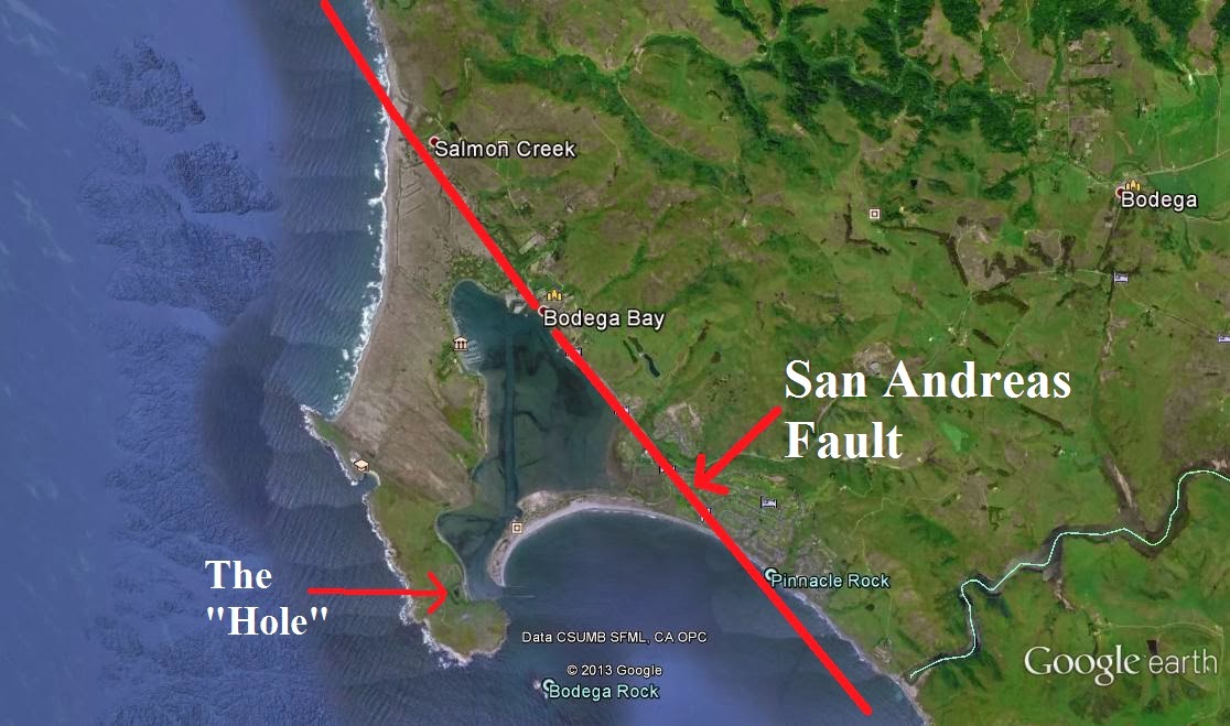
The Hole in the Head

So it was that in the 1950s that PG&E looked with great longing at the granite headland and decided that Bodega Head would be an ideal spot for a brand new nuclear power plant. The water they needed was there, there was solid ground to build on in contrast with the lousy slopes east of the fault in the Franciscan Complex. And not that they thought of things this way back then, but the site was fairly isolated from large population centers in case of bad accidents (which we all know NEVER happen with nuclear power plants).

And adjacent to the San Andreas fault! Its not like they didn't know it was there. In 1906, this part of the San Andreas shifted 15 feet or more. So they began digging a hole that would serve as the foundation for the power plant. As the plans and excavations progressed, local opposition began to grow, and ultimately the company somehow realized they were about to put a nuclear reactor practically on top of the San Andreas fault (subsidiary faults were discovered in the excavation pit; a geologist opined that“a worse foundation condition would be tough to envision.”). The pit became known as the "Hole in the Head".

So the nuclear power plant was never built, and Bodega Head remains as barren windswept ridge with beautiful cliffs composed of the northernmost exposures of the granitic rock of the Sierra Nevada. The Hole in the Head filled with seeping groundwater that now supports the local wildlife.

And so ends our little series of a part of the Sierra Nevada mountains that rise from the sea. I hope those of you who've followed it enjoyed the journey. I'll be putting up a compilation of the different posts in the series since it has been a rather off and on project over the last three months!

Birds of My Neighborhood: Geotripper Declares Cedar Waxwing Day!

$
0
0
One of my new year's resolutions which was actually not a resolution, and wasn't made in January, was to lose the extra pounds around the waist (there's a resolution no one ever thought of before...), so I have been walking, walking, walking for several months now. When the new camera landed in my hand, and there were fewer field trips and no geology, I started concentrating on photographing the local bird species in my neighborhood. That neighborhood includes some irrigation canals and cow pastures near my home, and a small "mini-wilderness" on my campus that includes a cat-tail ringed drainage pond and a small forest of mature oak trees and eucalyptus.
I have discovered much to my surprise (but of no surprise at all to my birder friends) that there is large diversity of species to be seen when one begins to look carefully. In my (freely admitted) ignorance, I dismissed all the small birds up in the trees as sparrows, but now that I am getting out on foot and looking carefully, those little black shapes are remarkably diverse. I've photographed more than thirty species so far, and I'm seeing new ones all the time.
One of my favorite discoveries early on were the Cedar Waxwings (Bombycilla cedrorum). They were out one morning a month or so ago, and then disappeared again, and I didn't see any for weeks. This morning they were out in force once more, and weren't very skittish about the guy standing in the middle of the road snapping pictures of them.
The waxwings nest in the northeastern part of the country and migrate into our area in the winter. They eat berries for the most part which actually protects them in an odd way. Cowbirds have been displacing lots of songbirds by laying eggs in the nests of the unsuspecting birds of other species. The young cowbirds hog all the food and sometimes kill the other chicks. But the cowbirds can't survive on fruit alone, so they don't tend to make it in waxwing nests.
The name of the bird comes from the waxy red secretions that are found on the secondaries. I managed to get several decent shots of the red feather tips. They maybe have something to do with courtship and mating (bling!).
Unlike many songbirds these days in North America, the Cedar Waxwings are doing pretty well. They are classed as a species of least concern, and there are an estimated 50 million plus of them living in the country. It's nice that we aren't destroying all of the interesting species that we share the planet with.

Okay, if you are worried that Geotripper isn't geological enough these days, don't! We will be headed out to Death Valley in a few weeks to take a look at the only place in California that is not suffering an exceptional drought (talk about the ultimate of ironies...). My new hobby of bird-watching prevents cabin fever!

Rebuilding What Was Lost: Wildlife Refuges in California's Great Valley

$
0
0
Yeah, I live in one of the most boring geologic landscapes imaginable. California's Central Valley (or Great Valley when we are suffering from low self-esteem) is one of the flattest places in the country, and it's dry and dusty most of the year (and with the extreme drought this year, it's been dusty for more than a year). Our geology is basically clay mixed with sand. And some caliche layers. How much bleaker can it get?
Well, how about the trees? Tangled chaotic woodlands that hobbits and elves would avoid. Broken branches, barren of leaves, what is there to love here?

And once you leave the confines of the river floodplains there is not even enough water to support brush let alone trees. Flat grassland plains that reach to the horizon. Okay, it's true that the origin of the Great Valley is rooted in geological violence. The valley is the remnant of a gigantic forearc basin that lay between the trench of the great Cascadia subduction zone and the Sierra Nevada magmatic arc. Volcanic eruptions once coated the region in thick ash layers, and intense earthquakes 30 times more powerful than the San Francisco earthquake of 1906 happened tens of thousands of times over millions of years. But now. Nothingness. So, I ask who could love such a place?

Well, it's for the birds. For them, this bleak environment is survival. As I have mentioned in recent posts, 95% of the original natural environment of the Great Valley has been co-opted for agricultural and urban development. Millions upon millions of birds once used the valley as a wintering ground or for critical food-gathering during their migrations elsewhere.

This week I was continuing my for-the-first-time exploration of one of the most spectacular displays of nature by paying visits to the San Joaquin River National Wildlife Refuge. I'm still sort of stunned that this has been in my own backyard, but was so easy to overlook (I should add that I never learned to surf despite living in Santa Barbara at one time, and never learned to ski despite living next to Lake Tahoe for a time; I just sorta miss stuff). Like the San Luis and Merced refuges, The San Joaquin River NWR provides year-round habitat for the local native species (not just the birds), but in winter it is home for thousands upon thousands of Snow Geese, Ross's Geese, Aleutian Cackling Geese, Sandhill Cranes and many others.

The San Joaquin River NWR is notable for the role it has played in the recovery of the Aleutian Cackling Geese, a species that was down to around 300 individuals in 1963 (foxes had been introduced on the islands where they nested). Many of them winter at San Joaquin, and in recent years they have numbered in the tens of thousands. Thousands of Sandhill Cranes can also be found there.

There are two main ways to explore the San Joaquin River NWR. There is a wildlife viewing platform on Beckwith Road about 8 miles west of Modesto. It makes absolute sense that people wouldn't be allowed to tramp all over the fields where the birds eat and roost, so the platform offers a high viewing point, and when I was there, thousands of birds were visible. Mrs. Geotripper was kind enough to make her video available of thousands of birds swarming around the plowed corn crops that were grown to feed the birds. It may recall the incredible flight of the Snow Geese at the Merced NWRI posted the other day.

Our other exploration was much quieter and intimate. South of Highway 132 and off of River Road and Dairy Road, there is a recently constructed foot trail that winds through 4 miles of fields and river woodlands. The seasonal wetland had not been flooded yet (if it will be at all, given the drought), so the vast flocks of migratory birds weren't present. On the other hand, we had a chance to seek out the resident year-round species.
White-tailed Kite (Elanus leucurus)
The caretakers of the refuge are in the process of reconstructing and rebuilding the habitat that existed prior to settlement by Europeans in the 1800s. Floodplains and riparian woodlands are being replanted with tens of thousands of trees, and former wetlands are being flooded regularly in an effort to reproduce seasonal flooding that took place prior to agricultural development. The squarish property/refuge boundaries and canals belie a complete return to a natural environment, but it is a richer environment than existed before.
A Song Sparrow (Melospiza melodia), perhaps?
We only had a short time to explore, covering only a mile of trail, and we didn't quite reach the section of the trail that parallels the San Joaquin River. A fair number of bird species were present, and a few allowed us to snap a few shots before they hopped into the underbrush.
Hermit Thrush (Catharus guttatus)
Being a rank amateur in the birding business, this was the first time I've ever identified a Hermit Thrush. Some people may have hundreds of birds on their life lists, but at least, I have an easier time adding new birds! A gentleman at the wildlife platform on Beckwith told us that dozens or hundreds of birders came out a few weeks back when someone spotted a rare Bunting species next to the platform. Some folks came from out-of-state for the chance to see it.
Egret in a tree at sunset

We didn't arrive until around four o'clock in the afternoon, so the sun was sinking fast as we made our way back to the parking lot walking atop the levee that protects some of the regional farmlands from flooding. A thicket of trees and brush kept us from seeing very far, but the chirping and hooting told us that numerous birds were hiding there.


One last Redwing Blackbird greeted us as we got back to the car and headed home. The San Joaquin River National Wildlife Refuge will be on our list for further exploration if the rains ever come and replenish the grasslands!

Where the Sierra Nevada Rises From the Sea: A Compilation of Posts

$
0
0


The Sierra Nevada of California is one of the great mountain ranges of the world. The soaring granite peaks, the deep glacial valleys, and the towering Sequoia trees represent some of the most beautiful sights to be seen anywhere on the planet. What is less known is that a portion of the Sierra Nevada is present elsewhere in the state. Around 30 million years ago the San Andreas fault system became active and sliced off a portion of the southern Sierra Nevada batholith and carried it northwest for several hundred miles. It now makes up a considerable portion of the Central California coastline, stretching from Big Sur on the south to Bodega Bay on the north. It is in my humble opinion one of the most beautiful and dynamic coastlines to be found anywhere on planet Earth.

I recently finished my latest blog series, and I present here a compilation of the fifteen entries in the series. If you missed any, here is the place to find them!
A sneak peak at the coming series. At this point I hadn't fully appreciated that I was going to be covering the entire Salinian Terrane, so I didn't mention the Sierra Nevada connection in the first post.
With the second post I hit upon the idea of the Sierra Nevada connection with my exploration of Limekiln State Park in the southern part of the Big Sur coast. It is a stunningly rugged stretch of coastal cliffs, and amazingly, the state of California almost shut down this beautiful place.
I punted on this one. I wrote this blog four months earlier about what may be the prettiest cove along the prettiest coast in the world. But the post fit well with the theme and scope of this series, so here it is: one of California's two tidal falls. And gigantic landslides.
A short distance inland from the coast we discover a gem of a state park, Pfeiffer Big Sur. The Sierra Nevada has the Sequoia trees, Big Sur has Coast Redwoods. And both the Sierra Nevada and Big Sur have huge wilderness areas. The wildlands around Big Sur are far less crowded.
Big Sur has some nice beaches, and not all of them are on the main highway. You have to be a bit of a sleuth to find Pfeiffer Beach, but it's worth the effort. And...garnet sand beaches!
One of the lesser known beach parks of the central California coast, Garrapata is a beautiful place that belies its horrendous name ("tick" beach). It has some of the nicest exposures of "Sierran" granite in the region.
Point Lobos was named for the seals and sea lions, not for terrestrial canines. It is another gem along the coast with unique exposures of conglomerates that accumulated in deep underwater canyons that rival Yosemite in their depths.
We finish our journey through Point Lobos and move north onto the Monterey Peninsular. Here it is trees that take up some of the geologic story. Monterey Pines grow naturally only in a few places, mainly on the Peninsula, but have become one of the most widely planted trees in the world. The Monterey Cypress is another unique species in the region.
We take a look at coastline of totally different character as we reach the Half Moon Bay region. There are prominent marine terraces that make for gentle scenery (and apparently great golf courses). There are some nice tidepools in the area, and during the right time of year, the Mavericks hit, the gigantic waves that bring surfers from around the world.
The San Andreas fault looms large in the history of the Central California coastline, but hasn't made an appearance on our journey until now. At Mussel Rock in Daly City, the fault trace moves offshore. The epicenter of the 1906 San Francisco may have been close by. And there is a famous folk song about the cookie-cutter houses on the high, unstable slopes...
Maybe you haven't heard that there is a big bridge that connects the city of San Francisco with the Marin Headlands and the rest of Northern California. It's not likely, but it's possible. There is some interesting geology going on underneath the bridge abutments.
The Marin Headlands expose rocks that were once part of the midocean ridge, the vast planet encircling mountain range that no mountain climber can ever hope to climb. The scenery on the Marin is majestic. And to invaders in World War II, the cliffs would have been deadly.
The Point Reyes Peninsula has wide sandy beaches, sand spits, a bay that may have been a landing for Sir Francis Drake, Tule Elk, and a lighthouse that has to put up with some really rotten weather.
If the Point Reyes Peninsular bears the brunt of violent Pacific Storms, the mountains of the peninsula shelter the lands to the east. Two bays along the San Andreas fault are peaceful and serene, which belies their violent origin.
We wrap up our exploration of the Sierra that rises from the sea with a look at Bodega Head, the site of a classic horror movie, and a horror story with a nuclear reactor as the main character. A reactor that was almost built on top of the San Andreas fault. It's also the northernmost exposure of the Salinian/Sierra Nevada rocks.

0.42 Inches of Rain Last Night! California's Long Drought is Over! Wait a Minute...The Problem of Day to Day Perception

$
0
0
No, the drought is not over. More on that in a minute...
I've been waxing eloquently (I hope, but whatever) about how thrilling it has been to be teaching in our new Science Community Center on the campus of Modesto Junior College.  The geology labs were placed on the third floor, much to my delight. I've spent the last two decades of my career ensconced in a windowless office and laboratory.

It's really cruel and unusual punishment to leave a geologist/earth scientist in a dungeon. We need to see the planet in action. One of my greatest delights has been the ability to look out my lab windows and get instant confirmation about atmospheric conditions. And today was special. It rained.
I'm sure there are those who don't think rain is all that remarkable, but this rainstorm was. It has not rained in most of California since Dec. 7, and that was barely a sprinkle. The only significant storm was in November, and our total before yesterday was about 1.3 inches. It should be around 7. By those standards, last night's 0.45 inches was a huge thing. But unfortunately it's not.

A normal year in our area will see around 13 inches of rainfall. The worst ever, in 1913, was 4.3 inches. We may be on track to do worse, and this is after two previous dry years. We are in trouble if some big storms don't develop soon. And there is no real sign yet that anything like that is happening. A hugely resilient high pressure cell, driven by exceptionally warm northern Pacific water is driving our storms north into Alaska, and apparently sending masses of arctic air into the rest of the country.

It's really easy to experience a rainstorm and think "the drought is over". But rain happens during droughts, just not enough of it. There is a lesson here for the politicians who earlier this month were experiencing frigid conditions of the the Polar Vortex and declared that global warming was a scam and a hoax. It still gets cold in winter despite global warming. But not as cold, and not as often. We are in the midst of global climate change, and the effects are very real. Sea level is rising, glaciers are melting, spring is arriving earlier (trees are blooming all over Modesto right now in January), and there are crippling droughts and heat waves (we've had 70 degrees days for weeks now in our area). I've been pleased by polls that show that vast majorities of the American people accept the fact of global warming and climate change, even in the most conservative of states like Oklahoma. If only their chosen leaders were as smart as their constituents. We are not the frogs in the boiling water; our politicians are.

It was a thrill to walk on the roof of the building and take pictures of the Coast Ranges, which I haven't seen clearly in weeks because of the constant dust in the air. Our politicians in Washington feel the cold air and say global warming isn't happening. By that standard, the air was clear today and therefore we have beaten air pollution. Our children won't get asthma anymore. Hooray!
Viewing all 1203 articles
Browse latest View live